TopoQuest Logo
Do you find TopoQuest useful?
Help keep TopoQuest running and adding new maps/features by donating!
Bitcoin:  19c7KJd3qBynnjoSw5npx9KScwjBe4ifkT
Litecoin:  LXs6TkuXGGXo1vDsWCkWVdjQX94eUKd6ui
Home View Maps Find Maps Find Places Resources & Links


Ludowici, Georgia Topographic Map

USGS Map Title: Ludowici, GA
USGS Map MRC: 31081F6
DRG (GeoTIFF) Download: o31081f6.tif


Neighboring USGS Topographic Map Quads:


  Glennville SE, GA  
31081G7
 

  Walthourville, GA  
31081G6
 

  Hinesville, GA  
31081G5
 

  Doctortown, GA  
31081F7
 

  Ludowici, GA  
31081F6
 

  East of Ludowici, GA  
31081F5
 

  Jesup East, GA  
31081E7
 

  Bug Island, GA  
31081E6
 

  Townsend, GA  
31081E5


Map MRC Location:

N32°
W82°
N32°
W81°
H8 H7 H6 H5 H4 H3 H2 H1
G8 G7 G6 G5 G4 G3 G2 G1
F8 F7 F6 F5 F4 F3 F2 F1
E8 E7 E6 E5 E4 E3 E2 E1
D8 D7 D6 D5 D4 D3 D2 D1
C8 C7 C6 C5 C4 C3 C2 C1
B8 B7 B6 B5 B4 B3 B2 B1
A8 A7 A6 A5 A4 A3 A2 A1
N31°
W82°
N31°
W81°

Ludowici, GA USGS 1:24K Topographic Map Preview:
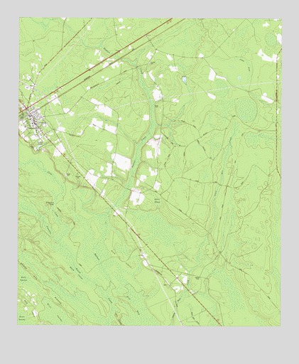
Ludowici, GA USGS Topographic Map
Click on map above to begin viewing in our Map Viewer.

This topographic map contains these locations and features:
Feature Name Type Latitude Longitude GNIS ID View Map
Baggs CemeteryCemeteryN31.6868°W81.7272°310711View Map
Black CalicoSwampN31.6466°W81.7223°311466View Map
Board Pile RidgesRidgeN31.6402°W81.7368°311586View Map
Brewer (historical)Populated PlaceN31.6785°W81.6826°348152View Map
Buck IslandIslandN31.6324°W81.7440°311967View Map
Chapman LakeLakeN31.6744°W81.7326°312571View Map
Church of GodChurchN31.7142°W81.7431°2502156View Map
Citizens CemeteryCemeteryN31.6970°W81.7417°312674View Map
City of LudowiciCivilN31.7096°W81.7457°2404970View Map
Concord CemeteryCemeteryN31.7319°W81.6882°312879View Map
Faith Baptist Christian AcademySchoolN31.7117°W81.7454°2502090View Map
Faith Baptist ChurchChurchN31.7057°W81.7424°2502909View Map
Fountain BranchStreamN31.6394°W81.7104°314307View Map
Gator HeadSwampN31.6653°W81.6828°314536View Map
Gill BaySwampN31.6344°W81.6940°314595View Map
Gill IslandIslandN31.6286°W81.7012°314596View Map
Goose PondSwampN31.7335°W81.6450°314703View Map
Ivy Melvin Hendrix Junior BridgeBridgeN31.7355°W81.7048°348163View Map
Jones CreekStreamN31.6585°W81.7304°316233View Map
Little Doctor CreekStreamN31.7494°W81.7334°317056View Map
Long County CourthouseBuildingN31.7133°W81.7465°348166View Map
Long County Emergency Medical ServiceBuildingN31.7192°W81.7494°2625439View Map
Long County High SchoolSchoolN31.7064°W81.7424°348167View Map
Long County Sheriff's OfficeBuildingN31.7080°W81.7416°2733757View Map
LudowiciPopulated PlaceN31.7080°W81.7423°356371View Map
Ludowici - Long County Volunteer Fire DepartmentBuildingN31.7106°W81.7444°2603632View Map
Ludowici - Long County Volunteer Fire Department Station 1BuildingN31.7192°W81.7493°2604876View Map
Ludowici Police DepartmentBuildingN31.7106°W81.7442°2733603View Map
Ludowici Post OfficePost OfficeN31.7086°W81.7408°2502486View Map
Ludowici South DivisionCivilN31.6586°W81.6527°1936375View Map
Ludowici Water Pollution Control PlantLocaleN31.7012°W81.7454°2502461View Map
Middleton CemeteryCemeteryN31.6419°W81.6790°348169View Map
Mount Sinai ChurchChurchN31.7430°W81.6898°348172View Map
Pine IslandIslandN31.6522°W81.7015°320612View Map
Pleasant Hill ChurchChurchN31.7399°W81.6954°348179View Map
Sharp CemeteryCemeteryN31.7144°W81.6832°322792View Map
Smiley Elementary SchoolSchoolN31.6944°W81.7306°2453168View Map
Smiley PondReservoirN31.6979°W81.7392°323091View Map
Smiley Pond DamDamN31.6980°W81.7404°342186View Map
Strangers CemeteryCemeteryN31.6866°W81.7218°323665View Map
Three Rivers Regional Library System Long County Public LibraryBuildingN31.7095°W81.7451°2502219View Map
Walker Middle SchoolSchoolN31.7043°W81.7413°348187View Map

Note: Coordinates in the location and feature list above are referenced to NAD83 datum.


Copyright (C) 2008-2024 Ryan Niemi / Sunset Dynamics ... All Rights Reserved