TopoQuest Logo
Do you find TopoQuest useful?
Help keep TopoQuest running and adding new maps/features by donating!
Bitcoin:  19c7KJd3qBynnjoSw5npx9KScwjBe4ifkT
Litecoin:  LXs6TkuXGGXo1vDsWCkWVdjQX94eUKd6ui
Home View Maps Find Maps Find Places Resources & Links


Bug Island, Georgia Topographic Map

USGS Map Title: Bug Island, GA
USGS Map MRC: 31081E6
DRG (GeoTIFF) Download: o31081e6.tif


Neighboring USGS Topographic Map Quads:


  Doctortown, GA  
31081F7
 

  Ludowici, GA  
31081F6
 

  East of Ludowici, GA  
31081F5
 

  Jesup East, GA  
31081E7
 

  Bug Island, GA  
31081E6
 

  Townsend, GA  
31081E5
 

  Manningtown, GA  
31081D7
 

  Everett, GA  
31081D6
 

  Cox, GA  
31081D5


Map MRC Location:

N32°
W82°
N32°
W81°
H8 H7 H6 H5 H4 H3 H2 H1
G8 G7 G6 G5 G4 G3 G2 G1
F8 F7 F6 F5 F4 F3 F2 F1
E8 E7 E6 E5 E4 E3 E2 E1
D8 D7 D6 D5 D4 D3 D2 D1
C8 C7 C6 C5 C4 C3 C2 C1
B8 B7 B6 B5 B4 B3 B2 B1
A8 A7 A6 A5 A4 A3 A2 A1
N31°
W82°
N31°
W81°

Bug Island, GA USGS 1:24K Topographic Map Preview:
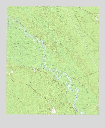
Bug Island, GA USGS Topographic Map
Click on map above to begin viewing in our Map Viewer.

This topographic map contains these locations and features:
Feature Name Type Latitude Longitude GNIS ID View Map
Alex CreekStreamN31.5094°W81.6587°354276View Map
Bernie LakeLakeN31.5345°W81.6479°311109View Map
Big Harper LakeLakeN31.5790°W81.7353°311386View Map
Big LakeLakeN31.5372°W81.6523°311395View Map
Big Water Oak RoundBendN31.6058°W81.7482°354730View Map
Box PointCapeN31.5663°W81.6965°311684View Map
Boyles IslandIslandN31.5822°W81.7296°311694View Map
Brosay SuckSwampN31.5616°W81.7115°311847View Map
Bug BluffCliffN31.5827°W81.6996°312004View Map
Bug IslandIslandN31.5752°W81.6829°312005View Map
Bug Suck LakeLakeN31.5763°W81.7074°312006View Map
Cogden LakeLakeN31.5262°W81.6676°312802View Map
Cogdens LakeLakeN31.5462°W81.6842°350562View Map
Cooter RidgeRidgeN31.5697°W81.6990°312956View Map
Crooked LakeLakeN31.5580°W81.7037°313149View Map
Dicks IslandIslandN31.5361°W81.6657°313470View Map
Doctors CreekStreamN31.5852°W81.7004°313514View Map
Double Yellow BluffCliffN31.5905°W81.7109°313586View Map
Duck PondLakeN31.5529°W81.6663°313702View Map
Gator LakeLakeN31.5673°W81.6924°314539View Map
Goose Run CreekStreamN31.6238°W81.6832°314704View Map
Harper SloughStreamN31.5572°W81.7043°315164View Map
Honey IslandIslandN31.6141°W81.7009°315612View Map
Horse FordCrossingN31.5797°W81.6773°332028View Map
John Lane DriftBendN31.5505°W81.6807°316134View Map
Joyner IslandIslandN31.5999°W81.7162°316293View Map
Little Harper LakeLakeN31.5714°W81.7302°317080View Map
Middleton ChurchChurchN31.6166°W81.6354°318096View Map
Middleton LakeLakeN31.5832°W81.6812°318097View Map
Miller LakeLakeN31.5407°W81.6607°318264View Map
Miller Lake Cut OffChannelN31.5347°W81.6632°318266View Map
Oberry BarBarN31.5319°W81.6551°319880View Map
Old Hell BightChannelN31.5505°W81.6890°319986View Map
Old Hell LakeLakeN31.5577°W81.6906°319987View Map
Old LandingLocaleN31.5961°W81.7248°332565View Map
Oxlot LandingLocaleN31.5563°W81.7251°332588View Map
Paradise ParkPopulated PlaceN31.5527°W81.7087°332602View Map
Penholoway CreekStreamN31.5533°W81.6965°356462View Map
Penholoway SwampSwampN31.5749°W81.7218°320359View Map
Rag RoundBendN31.5713°W81.6982°321280View Map
Round LakeLakeN31.5069°W81.6430°321958View Map
Sister Pine DriftChannelN31.5455°W81.6676°323042View Map
Sister Pine RoundBendN31.5419°W81.6809°323043View Map
Sour LakeLakeN31.5741°W81.7017°323227View Map
Spring LakeLakeN31.5195°W81.6407°323441View Map
Steamboat EddyRapidsN31.5919°W81.7240°323548View Map
Steamboat Old River SloughStreamN31.5930°W81.7254°323549View Map
Sturgeon HoleBayN31.5552°W81.7001°323712View Map
The PointCapeN31.5541°W81.6973°324054View Map
Twin LakesLakeN31.5502°W81.6768°324447View Map
Union ChurchChurchN31.5033°W81.6893°324511View Map
Upper Sansavilla LandingLocaleN31.5080°W81.6590°333312View Map
Wesley LakeLakeN31.5126°W81.6391°325031View Map
Yeomans LakeReservoirN31.5523°W81.7121°325628View Map

Note: Coordinates in the location and feature list above are referenced to NAD83 datum.


Copyright (C) 2008-2025 Ryan Niemi / Sunset Dynamics ... All Rights Reserved