TopoQuest Logo
Do you find TopoQuest useful?
Help keep TopoQuest running and adding new maps/features by donating!
Bitcoin:  19c7KJd3qBynnjoSw5npx9KScwjBe4ifkT
Litecoin:  LXs6TkuXGGXo1vDsWCkWVdjQX94eUKd6ui
Home View Maps Find Maps Find Places Resources & Links


Lummi Bay, Washington Topographic Map

USGS Map Title: Lummi Bay, WA
USGS Map MRC: 48122G6
DRG (GeoTIFF) Download: o48122g6.tif


Neighboring USGS Topographic Map Quads:


  Birch Point, WA  
48122H7
 

  Blaine, WA  
48122H6
 

  Bertrand Creek, WA  
48122H5


  Lummi Bay, WA  
48122G6
 

  Ferndale, WA  
48122G5
 

  Mount Constitution, WA  
48122F7
 

  Lummi Island, WA  
48122F6
 

  Eliza Island, WA  
48122F5


Map MRC Location:

N49°
W123°
N49°
W122°
H8 H7 H6 H5 H4 H3 H2 H1
G8 G7 G6 G5 G4 G3 G2 G1
F8 F7 F6 F5 F4 F3 F2 F1
E8 E7 E6 E5 E4 E3 E2 E1
D8 D7 D6 D5 D4 D3 D2 D1
C8 C7 C6 C5 C4 C3 C2 C1
B8 B7 B6 B5 B4 B3 B2 B1
A8 A7 A6 A5 A4 A3 A2 A1
N48°
W123°
N48°
W122°

Lummi Bay, WA USGS 1:24K Topographic Map Preview:
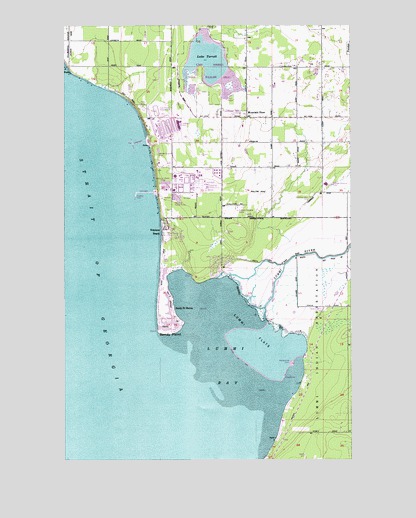
Lummi Bay, WA USGS Topographic Map
Click on map above to begin viewing in our Map Viewer.

This topographic map contains these locations and features:
Feature Name Type Latitude Longitude GNIS ID View Map
Blomquist Dairy (historical)LocaleN48.8619°W122.6294°2703952View Map
Cha-Choo-SenIslandN48.7921°W122.6657°1514707View Map
Cherry PointCapeN48.8618°W122.7482°1503940View Map
Cherry Point QuarryMineN48.8493°W122.6778°2605665View Map
Conoco Phillips Ferndale RefineryLocaleN48.8299°W122.6970°2606831View Map
Cornerstone Community ChurchChurchN48.8489°W122.6379°2609482View Map
Horizon Middle SchoolSchoolN48.8619°W122.6267°2606540View Map
Intalco Beach LandfillLocaleN48.8510°W122.7084°2605570View Map
Lake TerrellReservoirN48.8732°W122.6896°1532136View Map
Lake TerrellLakeN48.8656°W122.6895°1508954View Map
Lummi BayBayN48.7768°W122.6760°1506377View Map
Lummi Bay Sea PondsLocaleN48.7815°W122.6610°2605550View Map
Lummi FlatsFlatN48.7865°W122.6696°1506379View Map
Lummi Indian Business Council Sandy Point Wastewater Treatment PlantLocaleN48.8147°W122.7065°2610674View Map
Lummi ReservationCivilN48.7675°W122.6404°1511578View Map
Lummi Reservation DivisionCivilN48.7675°W122.6404°1939548View Map
Lummi RiverStreamN48.7901°W122.6638°1506383View Map
Mountain ViewPopulated PlaceN48.8482°W122.6713°1512487View Map
Neptune BeachPopulated PlaceN48.8159°W122.7077°1512499View Map
Sandy PointCapeN48.7862°W122.7052°1508113View Map
Sandy Point Golf CourseLocaleN48.8047°W122.6797°2608361View Map
Sandy Point MarinaLocaleN48.7976°W122.7072°2610320View Map
Sandy Point ShoresLocaleN48.7934°W122.7043°1508118View Map
Terrell Lake DamDamN48.8732°W122.6896°1532135View Map
Whatcom County Fire District 17 Sandy PointBuildingN48.7990°W122.7094°2643676View Map
Whatcom County Fire District 17 Sandy Point HeightsBuildingN48.8049°W122.6875°2643675View Map

Note: Coordinates in the location and feature list above are referenced to NAD83 datum.


Copyright (C) 2008-2024 Ryan Niemi / Sunset Dynamics ... All Rights Reserved