TopoQuest Logo
Do you find TopoQuest useful?
Help keep TopoQuest running and adding new maps/features by donating!
Bitcoin:  19c7KJd3qBynnjoSw5npx9KScwjBe4ifkT
Litecoin:  LXs6TkuXGGXo1vDsWCkWVdjQX94eUKd6ui
Home View Maps Find Maps Find Places Resources & Links


Lummi Island, Washington Topographic Map

USGS Map Title: Lummi Island, WA
USGS Map MRC: 48122F6
DRG (GeoTIFF) Download: o48122f6.tif


Neighboring USGS Topographic Map Quads:


  Lummi Bay, WA  
48122G6
 

  Ferndale, WA  
48122G5
 

  Mount Constitution, WA  
48122F7
 

  Lummi Island, WA  
48122F6
 

  Eliza Island, WA  
48122F5
 

  Blakely Island, WA  
48122E7
 

  Cypress Island, WA  
48122E6
 

  Anacortes North, WA  
48122E5


Map MRC Location:

N49°
W123°
N49°
W122°
H8 H7 H6 H5 H4 H3 H2 H1
G8 G7 G6 G5 G4 G3 G2 G1
F8 F7 F6 F5 F4 F3 F2 F1
E8 E7 E6 E5 E4 E3 E2 E1
D8 D7 D6 D5 D4 D3 D2 D1
C8 C7 C6 C5 C4 C3 C2 C1
B8 B7 B6 B5 B4 B3 B2 B1
A8 A7 A6 A5 A4 A3 A2 A1
N48°
W123°
N48°
W122°

Lummi Island, WA USGS 1:24K Topographic Map Preview:
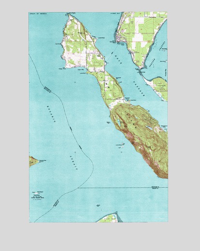
Lummi Island, WA USGS Topographic Map
Click on map above to begin viewing in our Map Viewer.

This topographic map contains these locations and features:
Feature Name Type Latitude Longitude GNIS ID View Map
Baker ReservoirReservoirN48.6843°W122.6703°1503135View Map
Bakers ReefBarN48.6837°W122.6782°1503136View Map
BeachPopulated PlaceN48.7159°W122.6838°1514870View Map
Beach Elementary SchoolSchoolN48.7247°W122.6919°1515166View Map
Boulder ReefBarN48.6347°W122.6906°1503491View Map
Brant IslandIslandN48.7268°W122.6282°1503533View Map
Brant PointCapeN48.7201°W122.6271°1503534View Map
Brown DamDamN48.7265°W122.6980°1532618View Map
Bumstead SpitCapeN48.7101°W122.6732°1503639View Map
Devils SlideCliffN48.6718°W122.6585°1504464View Map
Echo LodgeLocaleN48.7026°W122.6832°1512951View Map
Echo PointCapeN48.6968°W122.6596°1504672View Map
Fern PointCapeN48.7307°W122.7221°1504857View Map
Fisherman's Cove MarinaLocaleN48.7312°W122.6694°2610282View Map
Fishermans CoveBayN48.7304°W122.6666°1513922View Map
Gooseberry PointCapeN48.7321°W122.6721°1505198View Map
Hale PassageChannelN48.7154°W122.6655°1505341View Map
Hermosa BeachBeachN48.7271°W122.6424°1505474View Map
Holiday LakeReservoirN48.6782°W122.6396°1532751View Map
Holiday Lake DamDamN48.6782°W122.6396°1532750View Map
Lane SpitCapeN48.7332°W122.6916°1513886View Map
Lawrence PointCapeN48.6604°W122.7421°1506109View Map
Legoe BayBayN48.7154°W122.7016°1506125View Map
Loganita LodgeLocaleN48.7440°W122.7152°1506253View Map
Lovers BluffCliffN48.7132°W122.6996°1506345View Map
Lummi IslandPopulated PlaceN48.7246°W122.6863°1512409View Map
Lummi IslandIslandN48.6957°W122.6707°1506380View Map
Lummi Island CemeteryCemeteryN48.7140°W122.6944°2767969View Map
Lummi Island Congregational ChurchChurchN48.7142°W122.6948°2608511View Map
Lummi Island DivisionCivilN48.7356°W122.7256°1939547View Map
Lummi Island Est. DamDamN48.6798°W122.6413°1532163View Map
Lummi Island Ferry LandingLocaleN48.7204°W122.6815°2608117View Map
Lummi Island LibraryBuildingN48.7202°W122.6835°2610221View Map
Lummi Island Post OfficePost OfficeN48.7222°W122.6833°2606968View Map
Lummi Marine ParkParkN48.7254°W122.6588°1506381View Map
Lummi Nation Tribal SchoolSchoolN48.7288°W122.6543°1530992View Map
Lummi PeakPillarN48.6690°W122.6416°1506382View Map
Lummi PointCapeN48.7340°W122.6888°1534595View Map
Lummi RocksIslandN48.6709°W122.6671°1506384View Map
Lummi Youth AcademySchoolN48.7288°W122.6543°2518434View Map
Millers Field (historical)AirportN48.7234°W122.6980°1533825View Map
Neontawanta BeachBeachN48.7107°W122.6313°1511939View Map
North PeapodIslandN48.6420°W122.7460°1507091View Map
Point MigleyCapeN48.7484°W122.7152°1510720View Map
Portage ChannelChannelN48.7262°W122.6324°1507581View Map
Portage PointCapeN48.7154°W122.6518°1507584View Map
Richards MountainSummitN48.7371°W122.7024°1507797View Map
Smugglers CoveBayN48.6784°W122.6280°1508454View Map
Sunrise CoveBayN48.6973°W122.6641°1508835View Map
The PortageChannelN48.7134°W122.6518°1508974View Map
The WillowsLocaleN48.7359°W122.7188°1508980View Map
Village PointCapeN48.7165°W122.7185°1509229View Map
West BeachBeachN48.7407°W122.6710°1509383View Map
Whatcom County Ferry LandingLocaleN48.7313°W122.6702°2608105View Map
Whatcom County Fire District 11 Lummi Island Volunteer Fire DepartmentBuildingN48.7141°W122.6889°2643673View Map
Whatcom County Fire District 8 Station 34BuildingN48.7362°W122.6682°2619644View Map

Note: Coordinates in the location and feature list above are referenced to NAD83 datum.


Copyright (C) 2008-2025 Ryan Niemi / Sunset Dynamics ... All Rights Reserved