TopoQuest Logo
Do you find TopoQuest useful?
Help keep TopoQuest running and adding new maps/features by donating!
Bitcoin:  19c7KJd3qBynnjoSw5npx9KScwjBe4ifkT
Litecoin:  LXs6TkuXGGXo1vDsWCkWVdjQX94eUKd6ui
Home View Maps Find Maps Find Places Resources & Links


Eliza Island, Washington Topographic Map

USGS Map Title: Eliza Island, WA
USGS Map MRC: 48122F5
DRG (GeoTIFF) Download: o48122f5.tif


Neighboring USGS Topographic Map Quads:


  Lummi Bay, WA  
48122G6
 

  Ferndale, WA  
48122G5
 

  Bellingham North, WA  
48122G4
 

  Lummi Island, WA  
48122F6
 

  Eliza Island, WA  
48122F5
 

  Bellingham South, WA  
48122F4
 

  Cypress Island, WA  
48122E6
 

  Anacortes North, WA  
48122E5
 

  Bow, WA  
48122E4


Map MRC Location:

N49°
W123°
N49°
W122°
H8 H7 H6 H5 H4 H3 H2 H1
G8 G7 G6 G5 G4 G3 G2 G1
F8 F7 F6 F5 F4 F3 F2 F1
E8 E7 E6 E5 E4 E3 E2 E1
D8 D7 D6 D5 D4 D3 D2 D1
C8 C7 C6 C5 C4 C3 C2 C1
B8 B7 B6 B5 B4 B3 B2 B1
A8 A7 A6 A5 A4 A3 A2 A1
N48°
W123°
N48°
W122°

Eliza Island, WA USGS 1:24K Topographic Map Preview:
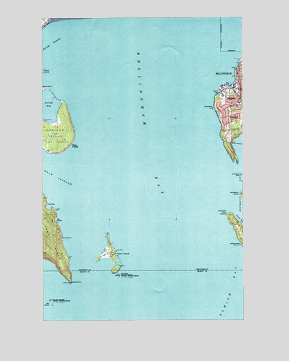
Eliza Island, WA USGS Topographic Map
Click on map above to begin viewing in our Map Viewer.

This topographic map contains these locations and features:
Feature Name Type Latitude Longitude GNIS ID View Map
Bellingham BayBayN48.7365°W122.5646°1503292View Map
Bellingham Public Library Fairhaven BranchBuildingN48.7215°W122.5018°2610111View Map
Bellingham Wastewater Treatment PlantLocaleN48.7177°W122.5138°2610645View Map
Breakwater ChurchChurchN48.7182°W122.5035°2609256View Map
Carter PointCapeN48.6407°W122.6080°1503831View Map
Chuckanut IslandIslandN48.6771°W122.5010°1503974View Map
Chuckanut RockBarN48.6848°W122.5007°1503977View Map
EdgemoorPopulated PlaceN48.7082°W122.5082°1531655View Map
Eliza IslandIslandN48.6523°W122.5835°1504707View Map
Eliza Island AirportAirportN48.6531°W122.5858°1533683View Map
Eliza RockBarN48.6434°W122.5771°1504708View Map
FairhavenPopulated PlaceN48.7182°W122.5068°1514176View Map
Fairhaven Marine Industrial ParkLocaleN48.7209°W122.5138°2605334View Map
Fairhaven Middle SchoolSchoolN48.7146°W122.5033°1504803View Map
Fairhaven Park and RideLocaleN48.7193°W122.5110°2608136View Map
Governors PointCapeN48.6684°W122.5107°1505207View Map
Inati BayBayN48.6718°W122.6221°1505699View Map
Padden CreekStreamN48.7204°W122.5068°1507256View Map
Padden Creek MarineLocaleN48.7223°W122.5083°2610265View Map
Pleasant BayBayN48.6665°W122.5016°1507483View Map
Point FrancisCapeN48.6937°W122.6168°1507516View Map
Port of Bellingham Marine ParkParkN48.7196°W122.5157°1514343View Map
Portage BayBayN48.7121°W122.6218°1507580View Map
Portage IslandIslandN48.7023°W122.6177°1507583View Map
Post PointCapeN48.7126°W122.5160°1507599View Map
Reil HarborBayN48.6665°W122.6177°1507776View Map
Sacred Heart Catholic Church Parish HallChurchN48.7222°W122.5003°2608329View Map
Saint James Presbyterian ChurchChurchN48.7252°W122.5002°2609277View Map
Starr RockBarN48.7337°W122.5024°1508699View Map
Three RocksSummitN48.6534°W122.5799°1512724View Map
Viti RocksIslandN48.6334°W122.6221°1509238View Map
Whiskey RockPillarN48.6557°W122.5027°1509456View Map

Note: Coordinates in the location and feature list above are referenced to NAD83 datum.


Copyright (C) 2008-2024 Ryan Niemi / Sunset Dynamics ... All Rights Reserved