TopoQuest Logo
Do you find TopoQuest useful?
Help keep TopoQuest running and adding new maps/features by donating!
Bitcoin:  19c7KJd3qBynnjoSw5npx9KScwjBe4ifkT
Litecoin:  LXs6TkuXGGXo1vDsWCkWVdjQX94eUKd6ui
Home View Maps Find Maps Find Places Resources & Links


Bay Center, Washington Topographic Map

USGS Map Title: Bay Center, WA
USGS Map MRC: 46123F8
DRG (GeoTIFF) Download: o46123f8.tif


Neighboring USGS Topographic Map Quads:


  Grayland, WA  
46124G1
 

  Western, WA  
46123G8
 

  Aberdeen SE, WA  
46123G7
 

  North Cove, WA  
46124F1
 

  Bay Center, WA  
46123F8
 

  South Bend, WA  
46123F7
 

  Oysterville, WA  
46124E1
 

  Nemah, WA  
46123E8
 

  North Nemah, WA  
46123E7


Map MRC Location:

N47°
W124°
N47°
W123°
H8 H7 H6 H5 H4 H3 H2 H1
G8 G7 G6 G5 G4 G3 G2 G1
F8 F7 F6 F5 F4 F3 F2 F1
E8 E7 E6 E5 E4 E3 E2 E1
D8 D7 D6 D5 D4 D3 D2 D1
C8 C7 C6 C5 C4 C3 C2 C1
B8 B7 B6 B5 B4 B3 B2 B1
A8 A7 A6 A5 A4 A3 A2 A1
N46°
W124°
N46°
W123°

Bay Center, WA USGS 1:24K Topographic Map Preview:
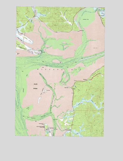
Bay Center, WA USGS Topographic Map
Click on map above to begin viewing in our Map Viewer.

This topographic map contains these locations and features:
Feature Name Type Latitude Longitude GNIS ID View Map
Bay CenterPopulated PlaceN46.6315°W123.9549°1511989View Map
Bay Center ChannelChannelN46.6423°W123.9716°1503206View Map
Bay Center Cutoff ChannelChannelN46.6554°W123.9485°1503207View Map
Bay Center Post OfficePost OfficeN46.6312°W123.9542°2606912View Map
Bayshore Recreational Vehicle ParkLocaleN46.7078°W123.9860°2608225View Map
Bone RiverStreamN46.6493°W123.9238°1503473View Map
BruceportPopulated PlaceN46.6793°W123.9002°1510843View Map
Bruceport ParkParkN46.6865°W123.8877°1503584View Map
Bush Pioneer County ParkParkN46.6345°W123.9582°1513254View Map
Cedar RiverStreamN46.7362°W123.9749°1503882View Map
Ellen SandsBarN46.6679°W123.9724°1504724View Map
Freshwater CreekStreamN46.7276°W123.9204°1505046View Map
Goose PointCapeN46.6359°W123.9582°1505196View Map
Hansen CreekStreamN46.6751°W123.9185°1505375View Map
Hawks PointCapeN46.7276°W123.9129°1505427View Map
Holton RanchLocaleN46.6707°W123.9196°1505569View Map
Kindred IslandIslandN46.7179°W123.9841°1505977View Map
Kindred SloughStreamN46.7154°W123.9910°1505978View Map
Niawiakum RiverStreamN46.6301°W123.9341°1506976View Map
Norris SloughStreamN46.7337°W123.9763°1507010View Map
North RiverStreamN46.7457°W123.8904°1507095View Map
Pacific County Fire District 5 Station 2BuildingN46.7110°W123.9959°2619670View Map
Palix RiverStreamN46.6365°W123.9446°1507261View Map
Pine IslandIslandN46.6693°W123.9571°1507439View Map
Pine Island ChannelChannelN46.6782°W123.9585°1507440View Map
Russell ChannelChannelN46.6818°W123.9346°1507964View Map
Smith CreekStreamN46.7470°W123.8857°1508425View Map
Snag IslandsIslandN46.6682°W123.9616°1508457View Map
Stony PointCapeN46.6729°W123.9263°1508760View Map
Teal Duck SloughStreamN46.7234°W123.9893°1509935View Map
Toke PointCapeN46.7057°W123.9677°1509040View Map
TokelandPopulated PlaceN46.7065°W123.9818°1512729View Map
Tokeland Census Designated PlaceCensusN46.7088°W123.9834°2409329View Map
Tokeland MarinaLocaleN46.7071°W123.9687°2610273View Map
VenicePopulated PlaceN46.7240°W123.9657°1514884View Map
Wilson PointCapeN46.6407°W123.9388°1509580View Map

Note: Coordinates in the location and feature list above are referenced to NAD83 datum.


Copyright (C) 2008-2025 Ryan Niemi / Sunset Dynamics ... All Rights Reserved