TopoQuest Logo
Do you find TopoQuest useful?
Help keep TopoQuest running and adding new maps/features by donating!
Bitcoin:  19c7KJd3qBynnjoSw5npx9KScwjBe4ifkT
Litecoin:  LXs6TkuXGGXo1vDsWCkWVdjQX94eUKd6ui
Home View Maps Find Maps Find Places Resources & Links


Grayland, Washington Topographic Map

USGS Map Title: Grayland, WA
USGS Map MRC: 46124G1
DRG (GeoTIFF) Download: o46124g1.tif


Neighboring USGS Topographic Map Quads:


  Point Brown, WA  
46124H2
 

  Westport, WA  
46124H1
 

  Hoquiam, WA  
46123H8


  Grayland, WA  
46124G1
 

  Western, WA  
46123G8


  North Cove, WA  
46124F1
 

  Bay Center, WA  
46123F8


Map MRC Location:

N47°
W125°
N47°
W124°
H8 H7 H6 H5 H4 H3 H2 H1
G8 G7 G6 G5 G4 G3 G2 G1
F8 F7 F6 F5 F4 F3 F2 F1
E8 E7 E6 E5 E4 E3 E2 E1
D8 D7 D6 D5 D4 D3 D2 D1
C8 C7 C6 C5 C4 C3 C2 C1
B8 B7 B6 B5 B4 B3 B2 B1
A8 A7 A6 A5 A4 A3 A2 A1
N46°
W125°
N46°
W124°

Grayland, WA USGS 1:24K Topographic Map Preview:
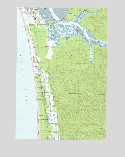
Grayland, WA USGS Topographic Map
Click on map above to begin viewing in our Map Viewer.

This topographic map contains these locations and features:
Feature Name Type Latitude Longitude GNIS ID View Map
Andrews CreekStreamN46.8373°W124.0229°1503035View Map
Barlow CreekStreamN46.8704°W124.0168°1503170View Map
Bay CityPopulated PlaceN46.8645°W124.0593°1503208View Map
Beardslee SloughStreamN46.8612°W124.0527°1503248View Map
BennLocaleN46.7990°W124.0907°1512994View Map
Coastal Community ChurchChurchN46.8571°W124.0991°2608671View Map
CohassettPopulated PlaceN46.8726°W124.1066°1513083View Map
Cohassett BeachPopulated PlaceN46.8684°W124.1118°1852939View Map
Cohassett Beach Census Designated PlaceCensusN46.8656°W124.1050°2407645View Map
Cohassett LakeLakeN46.8724°W124.1070°1504051View Map
Dempsey CreekStreamN46.8737°W124.0291°1504439View Map
Drainage Ditch Number 1CanalN46.7554°W124.0766°1533109View Map
Elk RiverStreamN46.8420°W124.0196°1504719View Map
Furford Cranberry MuseumBuildingN46.7872°W124.0861°2610432View Map
GraylandPopulated PlaceN46.8101°W124.0932°1505246View Map
Grayland Access State ParkParkN46.8095°W124.0985°1513010View Map
Grayland Beach State ParkParkN46.7887°W124.0929°1510670View Map
Grayland Census Designated PlaceCensusN46.8303°W124.0897°2408323View Map
Grayland Intergalactic AirportAirportN46.8008°W124.0740°2717109View Map
Grayland Post OfficePost OfficeN46.8098°W124.0929°2606954View Map
Grays Harbor Fire District 11 Grayland Fire DepartmentBuildingN46.8092°W124.0943°2606063View Map
HeatherPopulated PlaceN46.7715°W124.0810°1505445View Map
Horseshoe LakeLakeN46.8182°W124.0971°1514709View Map
Kenanna Recreational Vehicle ParkLocaleN46.7672°W124.0888°2608243View Map
Laidlaw IslandIslandN46.8604°W124.0771°1506048View Map
LaidlowPopulated PlaceN46.8615°W124.0738°1513016View Map
Long LakeLakeN46.7902°W124.0890°1506285View Map
Lutheran Church of Twin HarborsChurchN46.7863°W124.0841°2609527View Map
Mallard SloughStreamN46.8498°W124.0513°1506438View Map
North Fork Cedar RiverStreamN46.7590°W124.0229°1507036View Map
Ocosta Elementary SchoolSchoolN46.8622°W124.1000°1515105View Map
Ocosta Junior and Senior High SchoolSchoolN46.8643°W124.1009°1515106View Map
Ocosta School District 172 OfficeSchoolN46.8633°W124.1001°2518457View Map
Pacific County Fire District 5 North Cove Tokeland Shoalwater Bay Volunteer Fire Station 1BuildingN46.7712°W124.0816°2606064View Map
Roberts FarmLocaleN46.8379°W124.0793°1507829View Map
Saint Paul's Catholic ChurchChurchN46.8584°W124.0966°2609907View Map
Seastrand CreekStreamN46.7756°W124.0843°1508191View Map
Seastrand RidgeRidgeN46.7798°W124.0346°1508192View Map
Sopun InletBayN46.8540°W124.0436°1514938View Map
South Beach Christian CenterChurchN46.8244°W124.0956°2609528View Map
South Beach Christian Daycare CenterSchoolN46.8244°W124.0956°2605845View Map
South Beach State ParkParkN46.7720°W124.0916°1511855View Map
The Church of Jesus Christ of Latter Day SaintsChurchN46.8575°W124.1000°2609908View Map
Twin Harbors Beach State ParkParkN46.8568°W124.1068°1509146View Map
Twin Harbors BeachesAreaN46.8387°W124.1068°1513031View Map
West Fork Andrews CreekStreamN46.8231°W124.0232°1509389View Map
Westport DivisionCivilN46.8658°W124.0038°1939634View Map

Note: Coordinates in the location and feature list above are referenced to NAD83 datum.


Copyright (C) 2008-2025 Ryan Niemi / Sunset Dynamics ... All Rights Reserved