TopoQuest Logo
Do you find TopoQuest useful?
Help keep TopoQuest running and adding new maps/features by donating!
Bitcoin:  19c7KJd3qBynnjoSw5npx9KScwjBe4ifkT
Litecoin:  LXs6TkuXGGXo1vDsWCkWVdjQX94eUKd6ui
Home View Maps Find Maps Find Places Resources & Links


Luray, Virginia Topographic Map

USGS Map Title: Luray, VA
USGS Map MRC: 38078F4
DRG (GeoTIFF) Download: o38078f4.tif


Neighboring USGS Topographic Map Quads:


  Edinburg, VA  
38078G5
 

  Rileyville, VA  
38078G4
 

  Bentonville, VA  
38078G3
 

  Hamburg, VA  
38078F5
 

  Luray, VA  
38078F4
 

  Thornton Gap, VA  
38078F3
 

  Stanley, VA  
38078E5
 

  Big Meadows, VA  
38078E4
 

  Old Rag Mountain, VA  
38078E3


Map MRC Location:

N39°
W79°
N39°
W78°
H8 H7 H6 H5 H4 H3 H2 H1
G8 G7 G6 G5 G4 G3 G2 G1
F8 F7 F6 F5 F4 F3 F2 F1
E8 E7 E6 E5 E4 E3 E2 E1
D8 D7 D6 D5 D4 D3 D2 D1
C8 C7 C6 C5 C4 C3 C2 C1
B8 B7 B6 B5 B4 B3 B2 B1
A8 A7 A6 A5 A4 A3 A2 A1
N38°
W79°
N38°
W78°

Luray, VA USGS 1:24K Topographic Map Preview:
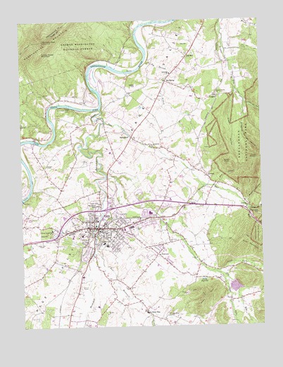
Luray, VA USGS Topographic Map
Click on map above to begin viewing in our Map Viewer.

This topographic map contains these locations and features:
Feature Name Type Latitude Longitude GNIS ID View Map
Andrew Jackson School (historical)SchoolN38.6648°W78.4728°1500364View Map
Antioch CemeteryCemeteryN38.6409°W78.4447°1500365View Map
Antioch ChurchChurchN38.6407°W78.4442°1481329View Map
Beahms ChapelChurchN38.6740°W78.4089°1481500View Map
Beahms Chapel CemeteryCemeteryN38.6734°W78.4081°1500368View Map
Bealers Ferry (historical)CrossingN38.7493°W78.4275°1500369View Map
Bell HollowValleyN38.6832°W78.3968°1481612View Map
Beth Eden ChurchChurchN38.6593°W78.4225°1481648View Map
Bethel Baptist ChurchChurchN38.6643°W78.4770°1500370View Map
Bethlehem ChurchChurchN38.6732°W78.3822°1481676View Map
Big SpringPopulated PlaceN38.7251°W78.4233°1495269View Map
Big Spring BranchStreamN38.7332°W78.4342°1481790View Map
Big Spring ChurchChurchN38.7268°W78.4233°1500371View Map
Bixler BridgeBridgeN38.7010°W78.4928°1481819View Map
Britton HollowValleyN38.6762°W78.3827°1482003View Map
BrooksidePopulated PlaceN38.6715°W78.4358°1500372View Map
Cave HillSummitN38.6631°W78.4862°1495359View Map
Christ Episcopal ChurchChurchN38.6623°W78.4578°1500373View Map
District 1, West LurayCivilN38.7402°W78.4161°1927559View Map
District 2, East LurayCivilN38.6792°W78.3810°1927308View Map
Dripping Springs HollowValleyN38.7159°W78.3821°1483089View Map
Dry RunStreamN38.6868°W78.4547°1483146View Map
Dry Run Number 101 DamDamN38.6418°W78.3914°1490536View Map
East Hawksbill CreekStreamN38.6562°W78.4614°1483214View Map
East Luray Shopping CenterLocaleN38.6648°W78.4467°1500374View Map
Evergreen Memorial GardensCemeteryN38.6650°W78.4420°1483319View Map
FairviewPopulated PlaceN38.6543°W78.4292°1495522View Map
Fletcher ChapelChurchN38.6910°W78.4864°1483461View Map
Fodder House MountainSummitN38.7365°W78.4886°1495549View Map
Forest HillsPopulated PlaceN38.6565°W78.4717°1500378View Map
Green Hill CemeteryCemeteryN38.6648°W78.4550°1500381View Map
Green HollowValleyN38.7210°W78.3869°1483804View Map
Hawksbill CreekStreamN38.7137°W78.4578°1483977View Map
HilldalePopulated PlaceN38.6673°W78.4336°1500386View Map
Holmes School (historical)SchoolN38.6746°W78.4139°1500387View Map
Jamesway Shopping CenterLocaleN38.6607°W78.4961°1500389View Map
Jewell HollowValleyN38.6727°W78.3830°1468740View Map
Kennedy PeakSummitN38.7420°W78.4877°1495782View Map
Kibler HillSummitN38.7240°W78.4384°1484581View Map
Kibler KnobSummitN38.6919°W78.3909°1484582View Map
KimballPopulated PlaceN38.6871°W78.4025°1495791View Map
Lake ArrowheadReservoirN38.6408°W78.3889°1490537View Map
Long School (historical)SchoolN38.7190°W78.4700°1500391View Map
Lord Fairfax Community CollegeSchoolN38.6699°W78.4613°2497738View Map
LurayPopulated PlaceN38.6654°W78.4595°1498510View Map
Luray Caverns AirportAirportN38.6676°W78.4978°1488529View Map
Luray Christian ChurchChurchN38.6635°W78.4581°1500393View Map
Luray DamDamN38.6785°W78.4997°1490542View Map
Luray Elementary SchoolSchoolN38.6580°W78.4555°1500394View Map
Luray High SchoolSchoolN38.6549°W78.4855°1500395View Map
Luray Police DepartmentBuildingN38.6657°W78.4584°2766974View Map
Luray Post OfficePost OfficeN38.6647°W78.4604°1500439View Map
Luray ReservoirReservoirN38.6785°W78.4997°1490543View Map
Luray ReservoirReservoirN38.6443°W78.4047°1485133View Map
Luray United Methodist ChurchChurchN38.6651°W78.4606°1500396View Map
Luray Volunteer Fire DepartmentBuildingN38.6651°W78.4574°2075292View Map
Luray Volunteer Rescue SquadBuildingN38.6641°W78.4688°2075295View Map
Main Street Baptist ChurchChurchN38.6657°W78.4595°1500397View Map
Mount Calvary CemeteryCemeteryN38.6298°W78.4236°1500402View Map
Mount Calvary Lutheran ChurchChurchN38.6298°W78.4228°1485572View Map
Mount Carmel Baptist ChurchChurchN38.6640°W78.4611°1500403View Map
Mount Carmel Regular Baptist ChurchChurchN38.6635°W78.4558°1500405View Map
Mount Zion ChurchChurchN38.6301°W78.4558°1485671View Map
Mud Pike School (historical)SchoolN38.6521°W78.4831°1500406View Map
New Luray High SchoolSchoolN38.6575°W78.4843°2497719View Map
North Fork Dry RunStreamN38.6471°W78.3992°1485893View Map
Oak HillPopulated PlaceN38.7346°W78.4128°1496028View Map
Oak HillSummitN38.7401°W78.4111°1496030View Map
Old County CemeteryCemeteryN38.6658°W78.4682°1500408View Map
Page County CourthouseBuildingN38.6640°W78.4650°1500409View Map
Page County Fire and Emergency Medical ServicesBuildingN38.6640°W78.4642°2721118View Map
Page County JailBuildingN38.6641°W78.4655°2767006View Map
Page County Sheriff's OfficeBuildingN38.6641°W78.4657°2767122View Map
Page County Sheriffs OfficeBuildingN38.6642°W78.4644°2075298View Map
Page Memorial HospitalHospitalN38.6623°W78.4687°1485352View Map
Pass RunStreamN38.7082°W78.4553°1486077View Map
Pine MountainSummitN38.6608°W78.3841°1496198View Map
Piney HillSummitN38.6382°W78.4008°1486249View Map
Rattleburg School (historical)SchoolN38.6379°W78.3778°1500412View Map
Rocky BranchStreamN38.6754°W78.3833°1486730View Map
Ruffner Ferry (historical)CrossingN38.6810°W78.4953°1500416View Map
Saint Johns Free Baptist ChurchChurchN38.6648°W78.4731°1500418View Map
Saint Marks Lutheran ChurchChurchN38.6657°W78.4550°1500421View Map
Shenandoah River LodgeBuildingN38.7143°W78.4747°1487180View Map
Singing TowerTowerN38.6635°W78.4789°1500428View Map
South Fork Dry RunStreamN38.6462°W78.3972°1487397View Map
Spring ViewPopulated PlaceN38.6746°W78.4242°1500430View Map
SpringfieldPopulated PlaceN38.7046°W78.4461°1496246View Map
Springfield ChurchChurchN38.6993°W78.4306°1487470View Map
Springfield Elementary SchoolSchoolN38.7283°W78.4215°1487471View Map
Stony ManPopulated PlaceN38.6307°W78.4345°1496267View Map
Stricklers Ferry (historical)CrossingN38.7148°W78.4720°1500433View Map
Three SistersSummitN38.6931°W78.3772°1487901View Map
Town of LurayCivilN38.6653°W78.4547°2391279View Map
VaughnPopulated PlaceN38.7187°W78.3975°1496351View Map
Vaughn Summit ChurchChurchN38.7190°W78.3970°1488116View Map
Virginia State Police Division 2 Area 14 OfficeBuildingN38.6602°W78.4814°2767146View Map
West Luray Elementary SchoolSchoolN38.6632°W78.4756°1500436View Map
WestluPopulated PlaceN38.6660°W78.4964°1500437View Map
Woodland ParkPopulated PlaceN38.6746°W78.4595°1496435View Map
WRAA-AM (Luray)TowerN38.6596°W78.4908°1502496View Map
WYFT-FM (Luray)TowerN38.6382°W78.4014°1502658View Map

Note: Coordinates in the location and feature list above are referenced to NAD83 datum.


Copyright (C) 2008-2024 Ryan Niemi / Sunset Dynamics ... All Rights Reserved