TopoQuest Logo
Do you find TopoQuest useful?
Help keep TopoQuest running and adding new maps/features by donating!
Bitcoin:  19c7KJd3qBynnjoSw5npx9KScwjBe4ifkT
Litecoin:  LXs6TkuXGGXo1vDsWCkWVdjQX94eUKd6ui
Home View Maps Find Maps Find Places Resources & Links


Stanley, Virginia Topographic Map

USGS Map Title: Stanley, VA
USGS Map MRC: 38078E5
DRG (GeoTIFF) Download: o38078e5.tif


Neighboring USGS Topographic Map Quads:


  New Market, VA  
38078F6
 

  Hamburg, VA  
38078F5
 

  Luray, VA  
38078F4
 

  Tenth Legion, VA  
38078E6
 

  Stanley, VA  
38078E5
 

  Big Meadows, VA  
38078E4
 

  Elkton West, VA  
38078D6
 

  Elkton East, VA  
38078D5
 

  Fletcher, VA  
38078D4


Map MRC Location:

N39°
W79°
N39°
W78°
H8 H7 H6 H5 H4 H3 H2 H1
G8 G7 G6 G5 G4 G3 G2 G1
F8 F7 F6 F5 F4 F3 F2 F1
E8 E7 E6 E5 E4 E3 E2 E1
D8 D7 D6 D5 D4 D3 D2 D1
C8 C7 C6 C5 C4 C3 C2 C1
B8 B7 B6 B5 B4 B3 B2 B1
A8 A7 A6 A5 A4 A3 A2 A1
N38°
W79°
N38°
W78°

Stanley, VA USGS 1:24K Topographic Map Preview:
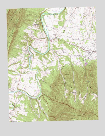
Stanley, VA USGS Topographic Map
Click on map above to begin viewing in our Map Viewer.

This topographic map contains these locations and features:
Feature Name Type Latitude Longitude GNIS ID View Map
AlmaPopulated PlaceN38.5912°W78.5575°1499049View Map
Basin HollowValleyN38.5426°W78.5127°1481486View Map
Battle CreekPopulated PlaceN38.6065°W78.5858°1499096View Map
Battle Creek ChurchChurchN38.6071°W78.5861°1500367View Map
Blue Ridge ChurchChurchN38.5418°W78.5453°1481861View Map
Chapman Dovel TrailTrailN38.5151°W78.5403°1482452View Map
Comer CemeteryCemeteryN38.5251°W78.5811°1482667View Map
Crooked RunStreamN38.5268°W78.5939°1482851View Map
Cub RunStreamN38.5565°W78.5920°1482871View Map
Cubbage HollowValleyN38.5430°W78.5130°1482872View Map
Cubbage MountainSummitN38.5276°W78.5389°1499314View Map
Devils TanyardSummitN38.5073°W78.5220°1482993View Map
District 4, NewportCivilN38.6099°W78.5607°1927419View Map
Dog Slaughter RidgeRidgeN38.5147°W78.5263°1483055View Map
Dovel HollowValleyN38.5564°W78.5512°1483079View Map
Dovel MountainSummitN38.5176°W78.5525°1499353View Map
Foltz CreekStreamN38.5771°W78.5942°1483471View Map
Fox HollowValleyN38.5830°W78.5963°1483516View Map
Fultz RunStreamN38.5268°W78.5864°1483563View Map
Grove HillPopulated PlaceN38.5287°W78.6122°1499509View Map
Grove Hill CemeteryCemeteryN38.5293°W78.6128°1500382View Map
Grove Hill Elementary SchoolSchoolN38.5286°W78.6117°1500383View Map
Grove Hill LandingLocaleN38.5273°W78.5939°1499510View Map
Grove Hill United Methodist ChurchChurchN38.5290°W78.6131°1500384View Map
Hawksclaw CreekStreamN38.5935°W78.5678°1483979View Map
Hickory RunStreamN38.5451°W78.5828°1484071View Map
Hidden River AirportAirportN38.5224°W78.5242°2675613View Map
Hillard ChapelChurchN38.5707°W78.5236°1484113View Map
Honey RunStreamN38.5798°W78.5658°1484187View Map
HoneyvillePopulated PlaceN38.5787°W78.5622°1499572View Map
InghamPopulated PlaceN38.5290°W78.5781°1499595View Map
Kettle HollowValleyN38.6022°W78.5906°1484573View Map
Leaks ChapelChurchN38.5768°W78.5464°1484749View Map
Leaks Chapel CemeteryCemeteryN38.5773°W78.5464°1500390View Map
Line RunStreamN38.5721°W78.5553°1484854View Map
Longs CemeteryCemeteryN38.6221°W78.5628°1485075View Map
Lucas HollowValleyN38.5642°W78.5361°1485125View Map
Lucas Hollow ChurchChurchN38.5307°W78.5306°1485126View Map
Massanutten Power PlantBuildingN38.5715°W78.5947°1500398View Map
Mill Creek ChurchChurchN38.6021°W78.5056°1485437View Map
Nauman School (historical)SchoolN38.5721°W78.5353°1500407View Map
NewportPopulated PlaceN38.5787°W78.5964°1499797View Map
Newport DamDamN38.5718°W78.5947°1490540View Map
Newport ReservoirReservoirN38.5718°W78.5947°1490541View Map
Page County High SchoolSchoolN38.5638°W78.6101°1500410View Map
Piney MountainSummitN38.5086°W78.5177°1499877View Map
Roundhead MountainSummitN38.5549°W78.5076°1499996View Map
Saint Luke CemeteryCemeteryN38.5954°W78.5561°1500419View Map
Saint Lukes ChurchChurchN38.5951°W78.5564°1486862View Map
Saint Pauls CemeteryCemeteryN38.5512°W78.6072°1500422View Map
Saint Pauls ChurchChurchN38.5201°W78.5820°1486879View Map
Saint Pauls ChurchChurchN38.5510°W78.6070°1486880View Map
Smith MountainSummitN38.5018°W78.5395°1500125View Map
StanleyPopulated PlaceN38.5754°W78.5025°1487517View Map
Stanley Elementary SchoolSchoolN38.5786°W78.5032°1500431View Map
Stanley Police DepartmentBuildingN38.5751°W78.5021°2766975View Map
Stanley Post OfficePost OfficeN38.5759°W78.5042°1500432View Map
Stanley Seventh - day Adventist SchoolSchoolN38.5776°W78.5168°2497735View Map
Stanley Volunteer Fire DepartmentBuildingN38.5748°W78.5033°2075293View Map
Stanley Volunteer Rescue SquadBuildingN38.5786°W78.5195°2075296View Map
Stark HollowValleyN38.6142°W78.5772°1487530View Map
Steam HollowValleyN38.5255°W78.5859°1487544View Map
Stony RunStreamN38.5915°W78.5656°1487635View Map
The PinnacleSummitN38.5508°W78.5391°1487842View Map
Town of StanleyCivilN38.5769°W78.5029°2391426View Map
Twin Valley ChurchChurchN38.5423°W78.5122°1488048View Map
Utz GapGapN38.5079°W78.5086°1488079View Map

Note: Coordinates in the location and feature list above are referenced to NAD83 datum.


Copyright (C) 2008-2025 Ryan Niemi / Sunset Dynamics ... All Rights Reserved