TopoQuest Logo
Do you find TopoQuest useful?
Help keep TopoQuest running and adding new maps/features by donating!
Bitcoin:  19c7KJd3qBynnjoSw5npx9KScwjBe4ifkT
Litecoin:  LXs6TkuXGGXo1vDsWCkWVdjQX94eUKd6ui
Home View Maps Find Maps Find Places Resources & Links


Luther, Oklahoma Topographic Map

USGS Map Title: Luther, OK
USGS Map MRC: 35097F2
DRG (GeoTIFF) Download: o35097f2.tif


Neighboring USGS Topographic Map Quads:


  Guthrie SE, OK  
35097G3
 

  Meridian, OK  
35097G2
 

  Carney, OK  
35097G1
 

  Arcadia, OK  
35097F3
 

  Luther, OK  
35097F2
 

  Wellston, OK  
35097F1
 

  Jones, OK  
35097E3
 

  Horseshoe Lake, OK  
35097E2
 

  Luther SE, OK  
35097E1


Map MRC Location:

N36°
W98°
N36°
W97°
H8 H7 H6 H5 H4 H3 H2 H1
G8 G7 G6 G5 G4 G3 G2 G1
F8 F7 F6 F5 F4 F3 F2 F1
E8 E7 E6 E5 E4 E3 E2 E1
D8 D7 D6 D5 D4 D3 D2 D1
C8 C7 C6 C5 C4 C3 C2 C1
B8 B7 B6 B5 B4 B3 B2 B1
A8 A7 A6 A5 A4 A3 A2 A1
N35°
W98°
N35°
W97°

Luther, OK USGS 1:24K Topographic Map Preview:
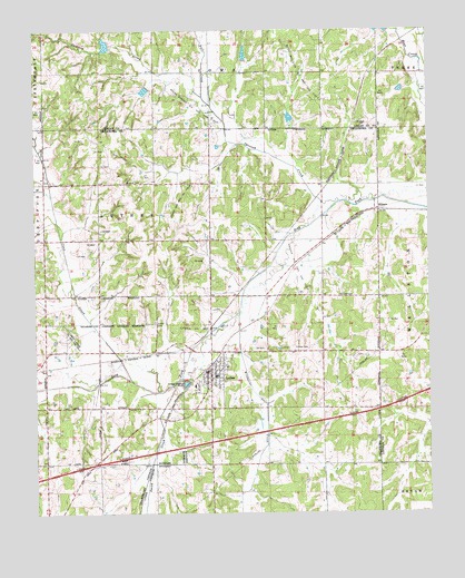
Luther, OK USGS Topographic Map
Click on map above to begin viewing in our Map Viewer.

This topographic map contains these locations and features:
Feature Name Type Latitude Longitude GNIS ID View Map
Bear Fall Coon Creek Site 20 DamDamN35.7267°W97.1686°1757751View Map
Bear Fall Coon Creek Site 20 ReservoirReservoirN35.7273°W97.1690°1757752View Map
Bear Fall Coon Creek Site 21 DamDamN35.7417°W97.1836°1757753View Map
Bear Fall Coon Creek Site 21 ReservoirReservoirN35.7439°W97.1833°1757754View Map
Bear Fall Coon Creek Site 26 DamDamN35.7467°W97.2253°1757765View Map
Bear Fall Coon Creek Site 26 ReservoirReservoirN35.7463°W97.2274°1757766View Map
Bear Fall Coon Creek Site 27 DamDamN35.7351°W97.2136°1757767View Map
Bear Fall Coon Creek Site 27 ReservoirReservoirN35.7345°W97.2149°1757768View Map
Bost Ranch AirportAirportN35.7131°W97.2258°1102541View Map
Coon CreekStreamN35.6595°W97.2200°1091654View Map
Fall CreekStreamN35.7328°W97.1956°1092752View Map
HibsawPopulated PlaceN35.7037°W97.1409°1100492View Map
LutherPopulated PlaceN35.6617°W97.1956°1095058View Map
Luther CemeteryCemeteryN35.6740°W97.2123°1095059View Map
Luther Elementary SchoolSchoolN35.6542°W97.1913°1793757View Map
Luther Gas and Oil FieldOilfieldN35.6903°W97.1964°1095060View Map
Luther High SchoolSchoolN35.6538°W97.1961°1793758View Map
Luther Middle SchoolSchoolN35.6550°W97.1914°1793756View Map
Luther Police DepartmentBuildingN35.6618°W97.1957°2757746View Map
Luther Volunteer Fire DepartmentBuildingN35.6621°W97.1944°2658645View Map
Oknoname 15 DamDamN35.6701°W97.2436°1752331View Map
Oknoname 15 ReservoirReservoirN35.6698°W97.2441°1752332View Map
Opossum CreekStreamN35.7056°W97.1531°1089499View Map
Opossum CreekStreamN35.7056°W97.1531°1096295View Map
Reunion CemeteryCemeteryN35.7108°W97.2214°1097178View Map
Saint Luke CemeteryCemeteryN35.6811°W97.1492°1097623View Map
Smith CreekStreamN35.6609°W97.2039°1098134View Map
South Garden Oil and Gas FieldOilfieldN35.7289°W97.1998°1098249View Map
Stamper Ranch Airport (historical)AirportN35.7220°W97.2050°1102540View Map
Tillman CemeteryCemeteryN35.6675°W97.1686°1098899View Map
Town of LutherCivilN35.6680°W97.1905°2412925View Map
Township of LutherCivilN35.6820°W97.1948°1824755View Map
West Luther Oil and Gas FieldOilfieldN35.6698°W97.2395°1099581View Map
West Wellston Oil and Gas FieldOilfieldN35.7401°W97.1636°1099622View Map
Wildhorse CreekStreamN35.6770°W97.1850°1099793View Map

Note: Coordinates in the location and feature list above are referenced to NAD83 datum.


Copyright (C) 2008-2025 Ryan Niemi / Sunset Dynamics ... All Rights Reserved