TopoQuest Logo
Do you find TopoQuest useful?
Help keep TopoQuest running and adding new maps/features by donating!
Bitcoin:  19c7KJd3qBynnjoSw5npx9KScwjBe4ifkT
Litecoin:  LXs6TkuXGGXo1vDsWCkWVdjQX94eUKd6ui
Home View Maps Find Maps Find Places Resources & Links


Bedford, Tennessee Topographic Map

USGS Map Title: Bedford, TN
USGS Map MRC: 35086D5
DRG (GeoTIFF) Download: o35086d5.tif


Neighboring USGS Topographic Map Quads:


  Farmington, TN  
35086E6
 

  Unionville, TN  
35086E5
 

  Deason, TN  
35086E4
 

  Belfast, TN  
35086D6
 

  Bedford, TN  
35086D5
 

  Shelbyville, TN  
35086D4
 

  Petersburg, TN  
35086C6
 

  Belleville, TN  
35086C5
 

  Lynchburg West, TN  
35086C4


Map MRC Location:

N36°
W87°
N36°
W86°
H8 H7 H6 H5 H4 H3 H2 H1
G8 G7 G6 G5 G4 G3 G2 G1
F8 F7 F6 F5 F4 F3 F2 F1
E8 E7 E6 E5 E4 E3 E2 E1
D8 D7 D6 D5 D4 D3 D2 D1
C8 C7 C6 C5 C4 C3 C2 C1
B8 B7 B6 B5 B4 B3 B2 B1
A8 A7 A6 A5 A4 A3 A2 A1
N35°
W87°
N35°
W86°

Bedford, TN USGS 1:24K Topographic Map Preview:
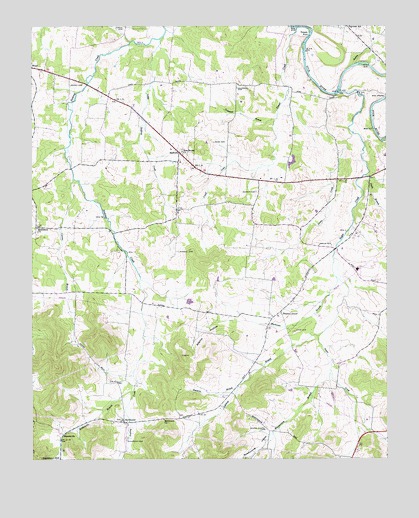
Bedford, TN USGS Topographic Map
Click on map above to begin viewing in our Map Viewer.

This topographic map contains these locations and features:
Feature Name Type Latitude Longitude GNIS ID View Map
Adams CemeteryCemeteryN35.4251°W86.5492°1319216View Map
Adams HollowValleyN35.4155°W86.5500°1275470View Map
Armstrong CemeteryCemeteryN35.3853°W86.6236°1319221View Map
Ashland BranchStreamN35.4104°W86.5242°1275943View Map
Ashland School (historical)SchoolN35.3929°W86.5539°1319223View Map
Barrett CemeteryCemeteryN35.4170°W86.5658°1319226View Map
Barrett-Carlisle CemeteryCemeteryN35.3906°W86.5155°1319227View Map
BedfordPopulated PlaceN35.4637°W86.5736°1276751View Map
Bedford Church of ChristChurchN35.4606°W86.5728°1310136View Map
Bedford Division (historical)CensusN35.4601°W86.5758°1648596View Map
Bethlehem ChurchChurchN35.4417°W86.6233°1277166View Map
Big Spring ChurchChurchN35.4104°W86.5336°1305235View Map
Bledsoe HollowValleyN35.3775°W86.5122°1277683View Map
Bluestocking BranchStreamN35.3995°W86.5203°1305317View Map
Bluestocking HollowValleyN35.3751°W86.5422°1304740View Map
Bradshaw CemeteryCemeteryN35.3753°W86.5414°1319248View Map
Brame CemeteryCemeteryN35.4565°W86.5428°1319249View Map
BranchvillePopulated PlaceN35.3829°W86.6133°1314724View Map
Branchville BranchStreamN35.3948°W86.5894°1278230View Map
Brown CemeteryCemeteryN35.4812°W86.5725°1319250View Map
Brown CemeteryCemeteryN35.3951°W86.6058°1319251View Map
Buchanan BranchStreamN35.4276°W86.5178°1278771View Map
Chanthaphone FarmLocaleN35.4692°W86.5531°2652558View Map
Coleman CemeteryCemeteryN35.4823°W86.5530°1280940View Map
Collier CemeteryCemeteryN35.4640°W86.5375°1319365View Map
Commissioner District 4CivilN35.4586°W86.5741°2464010View Map
Comstock BranchStreamN35.4734°W86.5392°1281053View Map
Cortner BranchStreamN35.4562°W86.6103°1281333View Map
Cunningham CemeteryCemeteryN35.4392°W86.5917°1319285View Map
Davis BranchStreamN35.4570°W86.5072°1282132View Map
Davis CemeteryCemeteryN35.4095°W86.6247°1319292View Map
Doughan CemeteryCemeteryN35.4570°W86.5561°1319295View Map
Dyer CemeteryCemeteryN35.4117°W86.5325°1283256View Map
Eastfield FarmsLocaleN35.4156°W86.5061°2652559View Map
Evans CemeteryCemeteryN35.3920°W86.5308°1319308View Map
Fairview SchoolSchoolN35.4998°W86.5142°1284037View Map
Gabbert CemeteryCemeteryN35.4003°W86.5314°1319313View Map
Gant CemeteryCemeteryN35.3817°W86.5628°1319315View Map
Gaunt CemeteryCemeteryN35.4831°W86.6114°1285256View Map
Greer CemeteryCemeteryN35.4367°W86.5194°1286213View Map
Harper CemeteryCemeteryN35.4445°W86.6205°1319330View Map
Harrison CemeteryCemeteryN35.4359°W86.6172°1319335View Map
Helton CemeteryCemeteryN35.4156°W86.6122°1319343View Map
Heltons Store (historical)LocaleN35.4406°W86.6236°1319344View Map
Ingle CemeteryCemeteryN35.3862°W86.5725°1319366View Map
Knight CemeteryCemeteryN35.4523°W86.5461°1290360View Map
Liberty Elementary SchoolSchoolN35.4298°W86.5103°1319385View Map
Little Sinking CreekStreamN35.4970°W86.5819°1291664View Map
Lone Oak Church of ChristChurchN35.3859°W86.5967°1319389View Map
Madison CemeteryCemeteryN35.4667°W86.5547°1319396View Map
Marsh CemeteryCemeteryN35.4598°W86.5692°1319398View Map
Moore Chapel CemeteryCemeteryN35.3842°W86.5425°1294283View Map
Moores Chapel (historical)ChurchN35.3840°W86.5422°1319414View Map
Muse CemeteryCemeteryN35.4570°W86.5247°1319443View Map
New Bethel Baptist ChurchChurchN35.4640°W86.5722°1295427View Map
New Bethel CemeteryCemeteryN35.4642°W86.5717°1319424View Map
O'Neal CemeteryCemeteryN35.4667°W86.6058°1319434View Map
Oakland School (historical)SchoolN35.4467°W86.5069°1319436View Map
Owens CemeteryCemeteryN35.4531°W86.5005°1319446View Map
Pisgah CemeteryCemeteryN35.4992°W86.5925°1297711View Map
Pleasant GrovePopulated PlaceN35.4176°W86.5375°1297797View Map
Pleasant Grove AirparkAirportN35.3992°W86.5543°2675508View Map
Pleasant Grove SchoolSchoolN35.4204°W86.5325°1297838View Map
Pleasant Grove United Methodist ChurchChurchN35.4173°W86.5375°1319454View Map
Porter-Cortner CemeteryCemeteryN35.4128°W86.5942°1319458View Map
Powell CreekStreamN35.4995°W86.5314°1298411View Map
Powell Creek SchoolSchoolN35.4826°W86.5333°1298413View Map
Rabbit BranchStreamN35.4892°W86.5111°1298770View Map
Red Oak SchoolSchoolN35.3759°W86.5164°1299078View Map
Redd CemeteryCemeteryN35.4667°W86.5608°1299092View Map
Renegar HollowValleyN35.3761°W86.5116°1299214View Map
RichmondPopulated PlaceN35.3856°W86.5919°1269895View Map
Richmond CemeteryCemeteryN35.3809°W86.5914°1299369View Map
Richmond ChurchChurchN35.3867°W86.5786°1299372View Map
Richmond SchoolSchoolN35.3865°W86.6008°1299377View Map
Rising Star RanchLocaleN35.4236°W86.5094°2652467View Map
Robinson CemeteryCemeteryN35.4965°W86.5100°1319469View Map
Russell CemeteryCemeteryN35.4351°W86.5739°1300308View Map
Shearin CemeteryCemeteryN35.3912°W86.5589°1319481View Map
Simmons BranchStreamN35.3956°W86.5528°1270290View Map
Sims CemeteryCemeteryN35.4792°W86.5136°1319493View Map
Snake CreekStreamN35.4695°W86.5122°1303704View Map
Solomons Chapel (historical)ChurchN35.4479°W86.5067°1319495View Map
Stephens CemeteryCemeteryN35.4856°W86.5361°1319505View Map
Stephenson CemeteryCemeteryN35.4978°W86.5844°1319506View Map
Sugar CreekStreamN35.4812°W86.5167°1271669View Map
Tallaferro CemeteryCemeteryN35.4059°W86.5839°1319515View Map
Talley CemeteryCemeteryN35.4884°W86.5008°1319516View Map
Temple FordCrossingN35.4978°W86.5269°1314385View Map
Thompson CemeteryCemeteryN35.4587°W86.5044°1319528View Map
Thompson Chapel (historical)ChurchN35.4834°W86.5725°1319530View Map
Thompson Grove SchoolSchoolN35.4826°W86.5706°1304081View Map
Thompsons Mill (historical)LocaleN35.4862°W86.5017°1644997View Map
Thompsons Shop (historical)LocaleN35.4570°W86.5033°1319531View Map
Tucker Store (historical)LocaleN35.4812°W86.5975°1319534View Map
Volunteer Fire Services Station 3 / WBTS Volunteer Fire DepartmentBuildingN35.4745°W86.5875°2654275View Map
Volunteer Fire Services Station 8 / WBTS Volunteer Fire DepartmentBuildingN35.4870°W86.6204°2653915View Map
Warners Mill (historical)LocaleN35.4895°W86.5067°1644998View Map
Wheel School (historical)SchoolN35.4870°W86.6214°1319560View Map
Whitesell-Wilhoite CemeteryCemeteryN35.4840°W86.5061°1319564View Map
Wilson CemeteryCemeteryN35.4937°W86.5569°1319570View Map
Woods School (historical)SchoolN35.4231°W86.6169°1319572View Map
Word CemeteryCemeteryN35.4403°W86.5389°1319573View Map

Note: Coordinates in the location and feature list above are referenced to NAD83 datum.


Copyright (C) 2008-2025 Ryan Niemi / Sunset Dynamics ... All Rights Reserved