TopoQuest Logo
Do you find TopoQuest useful?
Help keep TopoQuest running and adding new maps/features by donating!
Bitcoin:  19c7KJd3qBynnjoSw5npx9KScwjBe4ifkT
Litecoin:  LXs6TkuXGGXo1vDsWCkWVdjQX94eUKd6ui
Home View Maps Find Maps Find Places Resources & Links


Lynnville, Kentucky Topographic Map

USGS Map Title: Lynnville, KY
USGS Map MRC: 36088E5
DRG (GeoTIFF) Download: o36088e5.tif


Neighboring USGS Topographic Map Quads:


  Mayfield, KY  
36088F6
 

  Farmington, KY  
36088F5
 

  Kirksey, KY  
36088F4
 

  Cuba, KY  
36088E6
 

  Lynnville, KY  
36088E5
 

  Lynn Grove, KY  
36088E4
 

  Latham, TN  
36088D6
 

  Palmersville, TN  
36088D5
 

  Cottage Grove, TN  
36088D4


Map MRC Location:

N37°
W89°
N37°
W88°
H8 H7 H6 H5 H4 H3 H2 H1
G8 G7 G6 G5 G4 G3 G2 G1
F8 F7 F6 F5 F4 F3 F2 F1
E8 E7 E6 E5 E4 E3 E2 E1
D8 D7 D6 D5 D4 D3 D2 D1
C8 C7 C6 C5 C4 C3 C2 C1
B8 B7 B6 B5 B4 B3 B2 B1
A8 A7 A6 A5 A4 A3 A2 A1
N36°
W89°
N36°
W88°

Lynnville, KY USGS 1:24K Topographic Map Preview:
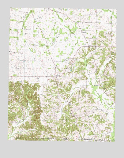
Lynnville, KY USGS Topographic Map
Click on map above to begin viewing in our Map Viewer.

This topographic map contains these locations and features:
Feature Name Type Latitude Longitude GNIS ID View Map
Andrus CemeteryCemeteryN36.5878°W88.5278°485951View Map
Barton CemeteryCemeteryN36.6005°W88.6072°486450View Map
Bell CityPopulated PlaceN36.5376°W88.5006°507487View Map
Boston CemeteryCemeteryN36.5024°W88.5350°2775665View Map
BoydsvillePopulated PlaceN36.5020°W88.5234°507566View Map
Boydsville CemeteryCemeteryN36.5009°W88.5256°1322270View Map
Burnett ChapelChurchN36.6120°W88.5459°488444View Map
Burnetts Chapel CemeteryCemeteryN36.6128°W88.5476°2775666View Map
Caldwell CreekStreamN36.5523°W88.5270°488592View Map
Carter CemeteryCemeteryN36.5542°W88.5125°488999View Map
Cook CemeteryCemeteryN36.5021°W88.5324°1281117View Map
Cook CemeteryCemeteryN36.5019°W88.5327°489996View Map
Cook CemeteryCemeteryN36.5275°W88.5247°489997View Map
CooksvillePopulated PlaceN36.6123°W88.5234°507748View Map
Cooter CreekStreamN36.5401°W88.5153°490068View Map
Cuba Elementary SchoolSchoolN36.5839°W88.6244°490452View Map
Cuba Fire Department Station 2 LynnvilleBuildingN36.5568°W88.5685°2636652View Map
Day CemeteryCemeteryN36.5473°W88.5430°490699View Map
Doublin CemeteryCemeteryN36.5756°W88.5561°491053View Map
East Fork Terrapin CreekStreamN36.5506°W88.5250°491483View Map
FairbanksPopulated PlaceN36.5239°W88.5475°507966View Map
Gilliam CemeteryCemeteryN36.6162°W88.6098°492845View Map
High Hill CemeteryCemeteryN36.5207°W88.6249°494183View Map
Jones CemeteryCemeteryN36.5057°W88.5128°495461View Map
Kesterson CemeteryCemeteryN36.6196°W88.6046°495695View Map
LynnvillePopulated PlaceN36.5603°W88.5692°497387View Map
Morris CemeteryCemeteryN36.5503°W88.5148°498611View Map
Mud CreekStreamN36.5023°W88.6231°498978View Map
Oakland CemeteryCemeteryN36.5839°W88.5049°499734View Map
Perry CemeteryCemeteryN36.6034°W88.6231°500422View Map
Pittman CemeteryCemeteryN36.5261°W88.5495°500783View Map
Rhodes ChapelChurchN36.5409°W88.5889°501757View Map
Rhodes Chapel CemeteryCemeteryN36.5414°W88.5888°2775664View Map
Seay CemeteryCemeteryN36.5279°W88.5685°503135View Map
Sedalia DivisionCivilN36.5782°W88.5843°1937247View Map
Sims CemeteryCemeteryN36.5040°W88.5427°503545View Map
Tibbs CemeteryCemeteryN36.5701°W88.5694°505264View Map
Tri CityPopulated PlaceN36.5898°W88.5320°505489View Map
VealsburgPopulated PlaceN36.6028°W88.5400°509277View Map
West Fork Terrapin CreekStreamN36.5506°W88.5250°506452View Map
Wheeler CemeteryCemeteryN36.5263°W88.5107°506529View Map

Note: Coordinates in the location and feature list above are referenced to NAD83 datum.


Copyright (C) 2008-2025 Ryan Niemi / Sunset Dynamics ... All Rights Reserved