TopoQuest Logo
Do you find TopoQuest useful?
Help keep TopoQuest running and adding new maps/features by donating!
Bitcoin:  19c7KJd3qBynnjoSw5npx9KScwjBe4ifkT
Litecoin:  LXs6TkuXGGXo1vDsWCkWVdjQX94eUKd6ui
Home View Maps Find Maps Find Places Resources & Links


Lynn Grove, Kentucky Topographic Map

USGS Map Title: Lynn Grove, KY
USGS Map MRC: 36088E4
DRG (GeoTIFF) Download: o36088e4.tif


Neighboring USGS Topographic Map Quads:


  Farmington, KY  
36088F5
 

  Kirksey, KY  
36088F4
 

  Dexter, KY  
36088F3
 

  Lynnville, KY  
36088E5
 

  Lynn Grove, KY  
36088E4
 

  Murray, KY  
36088E3
 

  Palmersville, TN  
36088D5
 

  Cottage Grove, TN  
36088D4
 

  Puryear, TN  
36088D3


Map MRC Location:

N37°
W89°
N37°
W88°
H8 H7 H6 H5 H4 H3 H2 H1
G8 G7 G6 G5 G4 G3 G2 G1
F8 F7 F6 F5 F4 F3 F2 F1
E8 E7 E6 E5 E4 E3 E2 E1
D8 D7 D6 D5 D4 D3 D2 D1
C8 C7 C6 C5 C4 C3 C2 C1
B8 B7 B6 B5 B4 B3 B2 B1
A8 A7 A6 A5 A4 A3 A2 A1
N36°
W89°
N36°
W88°

Lynn Grove, KY USGS 1:24K Topographic Map Preview:
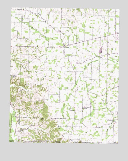
Lynn Grove, KY USGS Topographic Map
Click on map above to begin viewing in our Map Viewer.

This topographic map contains these locations and features:
Feature Name Type Latitude Longitude GNIS ID View Map
Beech Grove CemeteryCemeteryN36.5609°W88.4986°2775669View Map
Beech Grove ChurchChurchN36.5612°W88.4973°486715View Map
Browns GrovePopulated PlaceN36.6239°W88.4873°507595View Map
Brush Island CemeteryCemeteryN36.6114°W88.4798°488092View Map
Concord CemeteryCemeteryN36.5738°W88.3852°489920View Map
CrosslandPopulated PlaceN36.5006°W88.3803°490399View Map
Doran CemeteryCemeteryN36.5756°W88.4941°491014View Map
Harris GrovePopulated PlaceN36.5701°W88.4278°508197View Map
Harris Grove Fire StationBuildingN36.5336°W88.4160°2637203View Map
Haynes CreekStreamN36.5778°W88.3823°493923View Map
Hazel-Lynn Grove DivisionCivilN36.5639°W88.4184°1936908View Map
Jackson CemeteryCemeteryN36.5883°W88.4104°495106View Map
Jackson CreekStreamN36.5776°W88.3867°495117View Map
Jetton CemeteryCemeteryN36.5382°W88.4898°495256View Map
Lassiter CemeteryCemeteryN36.5039°W88.4432°495995View Map
Lassiter CemeteryCemeteryN36.5659°W88.4801°495996View Map
Lynn GrovePopulated PlaceN36.5892°W88.4381°497381View Map
Lynn Grove Fire StationBuildingN36.6087°W88.4418°2637188View Map
Moore CemeteryCemeteryN36.5359°W88.4092°498538View Map
Moore MineMineN36.5006°W88.4675°2724758View Map
Mount Pleasant ChurchChurchN36.5220°W88.4648°498827View Map
ProtemusPopulated PlaceN36.5534°W88.4792°508880View Map
Providence ChurchChurchN36.5303°W88.4259°501370View Map
Rose CemeteryCemeteryN36.5812°W88.3803°502319View Map
Salem CemeteryCemeteryN36.6038°W88.4440°2775671View Map
Salem ChurchChurchN36.6039°W88.4428°502775View Map
Sand CreekStreamN36.5153°W88.4981°502901View Map
Sand Fork CreekStreamN36.5162°W88.4928°502903View Map
Sinking Spring CemeteryCemeteryN36.5819°W88.3974°2775682View Map
Sinking Spring ChurchChurchN36.5809°W88.3973°503574View Map
South Pleasant Grove CemeteryCemeteryN36.5200°W88.3798°2775683View Map
South Pleasant Grove ChurchChurchN36.5206°W88.3800°503969View Map
Story ChapelChurchN36.5114°W88.4853°504532View Map
Story Chapel CemeteryCemeteryN36.5125°W88.4863°2775670View Map
Taylors StoreLocaleN36.5331°W88.4162°505044View Map
Waterfield CemeteryCemeteryN36.6171°W88.3948°506263View Map
Williams ChapelChurchN36.5881°W88.4517°506811View Map
Williams CreekStreamN36.5976°W88.4595°506812View Map
WiswellPopulated PlaceN36.5834°W88.3881°509391View Map
Young CemeteryCemeteryN36.5889°W88.4639°507239View Map

Note: Coordinates in the location and feature list above are referenced to NAD83 datum.


Copyright (C) 2008-2025 Ryan Niemi / Sunset Dynamics ... All Rights Reserved