TopoQuest Logo
Do you find TopoQuest useful?
Help keep TopoQuest running and adding new maps/features by donating!
Bitcoin:  19c7KJd3qBynnjoSw5npx9KScwjBe4ifkT
Litecoin:  LXs6TkuXGGXo1vDsWCkWVdjQX94eUKd6ui
Home View Maps Find Maps Find Places Resources & Links


Kirksey, Kentucky Topographic Map

USGS Map Title: Kirksey, KY
USGS Map MRC: 36088F4
DRG (GeoTIFF) Download: o36088f4.tif


Neighboring USGS Topographic Map Quads:


  Westplains, KY  
36088G5
 

  Oak Level, KY  
36088G4
 

  Hardin, KY  
36088G3
 

  Farmington, KY  
36088F5
 

  Kirksey, KY  
36088F4
 

  Dexter, KY  
36088F3
 

  Lynnville, KY  
36088E5
 

  Lynn Grove, KY  
36088E4
 

  Murray, KY  
36088E3


Map MRC Location:

N37°
W89°
N37°
W88°
H8 H7 H6 H5 H4 H3 H2 H1
G8 G7 G6 G5 G4 G3 G2 G1
F8 F7 F6 F5 F4 F3 F2 F1
E8 E7 E6 E5 E4 E3 E2 E1
D8 D7 D6 D5 D4 D3 D2 D1
C8 C7 C6 C5 C4 C3 C2 C1
B8 B7 B6 B5 B4 B3 B2 B1
A8 A7 A6 A5 A4 A3 A2 A1
N36°
W89°
N36°
W88°

Kirksey, KY USGS 1:24K Topographic Map Preview:
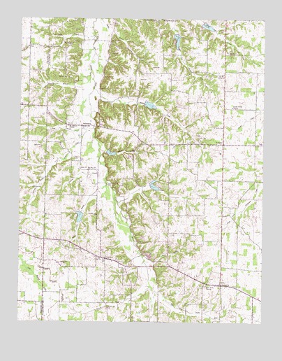
Kirksey, KY USGS Topographic Map
Click on map above to begin viewing in our Map Viewer.

This topographic map contains these locations and features:
Feature Name Type Latitude Longitude GNIS ID View Map
Asbury CemeteryCemeteryN36.6813°W88.4503°2775679View Map
BackusburgPopulated PlaceN36.7059°W88.4684°507433View Map
Bazzell CemeteryCemeteryN36.6495°W88.4789°486500View Map
Bean CemeteryCemeteryN36.7346°W88.4715°486511View Map
Boyd CemeteryCemeteryN36.7249°W88.4387°487764View Map
Chester (historical)Populated PlaceN36.7464°W88.4526°2743616View Map
Clear CreekStreamN36.6742°W88.4495°489604View Map
ColdwaterPopulated PlaceN36.6509°W88.4553°489801View Map
Coldwater Church of Christ CemeteryCemeteryN36.6511°W88.4596°2775672View Map
Collie CemeteryCemeteryN36.7371°W88.4359°489841View Map
Cook BranchStreamN36.6503°W88.4356°489993View Map
Crawford CemeteryCemeteryN36.7087°W88.4889°490305View Map
Crittendon CemeteryCemeteryN36.6615°W88.4998°2775668View Map
Damon CreekStreamN36.7223°W88.4620°490545View Map
Darnell CreekStreamN36.6401°W88.4325°490601View Map
Edwards BranchStreamN36.7281°W88.4634°491575View Map
Edwards CemeteryCemeteryN36.7261°W88.4764°491576View Map
GoloPopulated PlaceN36.7389°W88.4953°492948View Map
Goshen United Methodist ChurchChurchN36.6408°W88.3956°493041View Map
Guier BranchStreamN36.7051°W88.4617°493462View Map
Hargrove BranchStreamN36.6862°W88.4595°493743View Map
Jones CemeteryCemeteryN36.7453°W88.3980°2775676View Map
KirkseyPopulated PlaceN36.6987°W88.3953°495803View Map
Kirksey CemeteryCemeteryN36.6983°W88.4015°2775678View Map
Kirksey DivisionCivilN36.6990°W88.3893°1937091View Map
Kirksey Fire StationBuildingN36.6826°W88.3981°2637202View Map
Locust Grove ChurchChurchN36.7137°W88.3909°496948View Map
Mayfield Fire and Rescue Station 2BuildingN36.7377°W88.4976°2637197View Map
Minnow BranchStreamN36.6914°W88.4806°498416View Map
Minnow CemeteryCemeteryN36.6803°W88.4928°2775673View Map
Mount Carmel CemeteryCemeteryN36.7362°W88.3893°2775677View Map
Mount Carmel ChurchChurchN36.7359°W88.3900°498700View Map
Mount Hebron ChurchChurchN36.7059°W88.4750°498739View Map
Mount Olive CemeteryCemeteryN36.7398°W88.4743°2775674View Map
Mount Olive ChurchChurchN36.7395°W88.4739°498790View Map
Mount Zion CemeteryCemeteryN36.7241°W88.4723°498914View Map
Sand Lick BranchStreamN36.6823°W88.4550°502926View Map
Smith BranchStreamN36.7431°W88.4617°503726View Map
Smith CemeteryCemeteryN36.6974°W88.4893°503742View Map
Smith CemeteryCemeteryN36.7453°W88.4693°503745View Map
StellaPopulated PlaceN36.6403°W88.3967°509123View Map
Stella Goshen CemeteryCemeteryN36.6410°W88.3958°2775681View Map
Tucker CemeteryCemeteryN36.7009°W88.4085°505534View Map
Turner BranchStreamN36.6964°W88.4589°505645View Map
Wade CemeteryCemeteryN36.6885°W88.4689°506087View Map
Waters CemeteryCemeteryN36.7167°W88.4736°506267View Map
Watson CemeteryCemeteryN36.6924°W88.4719°506280View Map
Watson CreekStreamN36.7045°W88.4650°506283View Map
West Fork CemeteryCemeteryN36.6392°W88.4040°2775680View Map
West Fork ChurchChurchN36.6398°W88.4034°506425View Map
Wyatt CemeteryCemeteryN36.7361°W88.4532°507173View Map
Yandell CemeteryCemeteryN36.7298°W88.4288°2775675View Map

Note: Coordinates in the location and feature list above are referenced to NAD83 datum.


Copyright (C) 2008-2025 Ryan Niemi / Sunset Dynamics ... All Rights Reserved