TopoQuest Logo
Do you find TopoQuest useful?
Help keep TopoQuest running and adding new maps/features by donating!
Bitcoin:  19c7KJd3qBynnjoSw5npx9KScwjBe4ifkT
Litecoin:  LXs6TkuXGGXo1vDsWCkWVdjQX94eUKd6ui
Home View Maps Find Maps Find Places Resources & Links


M F Mountain, Colorado Topographic Map

USGS Map Title: M F Mountain, CO
USGS Map MRC: 40108C5
DRG (GeoTIFF) Download: o40108c5.tif


Neighboring USGS Topographic Map Quads:


  Haystack Rock, CO  
40108D6
 

  Indian Water Canyon, CO  
40108D5
 

  Twelvemile Mesa, CO  
40108D4
 

  Skull Creek, CO  
40108C6
 

  M F Mountain, CO  
40108C5
 

  Elk Springs, CO  
40108C4
 

  Cactus Reservoir, CO  
40108B6
 

  Divide Creek, CO  
40108B5
 

  Rough Gulch, CO  
40108B4


Map MRC Location:

N41°
W109°
N41°
W108°
H8 H7 H6 H5 H4 H3 H2 H1
G8 G7 G6 G5 G4 G3 G2 G1
F8 F7 F6 F5 F4 F3 F2 F1
E8 E7 E6 E5 E4 E3 E2 E1
D8 D7 D6 D5 D4 D3 D2 D1
C8 C7 C6 C5 C4 C3 C2 C1
B8 B7 B6 B5 B4 B3 B2 B1
A8 A7 A6 A5 A4 A3 A2 A1
N40°
W109°
N40°
W108°

M F Mountain, CO USGS 1:24K Topographic Map Preview:
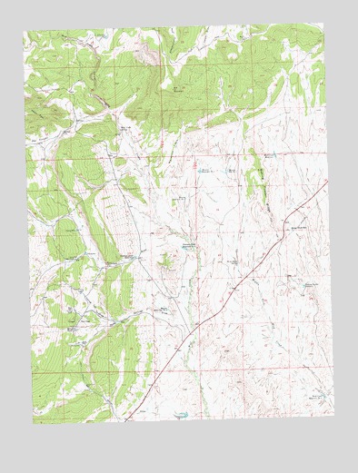
M F Mountain, CO USGS Topographic Map
Click on map above to begin viewing in our Map Viewer.

This topographic map contains these locations and features:
Feature Name Type Latitude Longitude GNIS ID View Map
Bailey PlaceLocaleN40.3022°W108.6068°170963View Map
Baking Powder ReservoirReservoirN40.2916°W108.5119°170910View Map
Baking Powder RidgeRidgeN40.3222°W108.5254°170915View Map
Bar 74 RanchLocaleN40.2797°W108.6079°170983View Map
Horse DrawValleyN40.2524°W108.5538°170972View Map
Horse Draw WellWellN40.2625°W108.6032°170967View Map
Little Star Number One MineMineN40.3508°W108.6195°1683133View Map
M F MountainSummitN40.3716°W108.5643°170960View Map
Mancos Reservoir Number 1ReservoirN40.3288°W108.5424°170912View Map
Mancos Reservoir Number 2ReservoirN40.3289°W108.5538°170961View Map
Mancos Reservoir Number 3ReservoirN40.3204°W108.5599°170981View Map
Mancos Reservoir Number 4ReservoirN40.2853°W108.5685°170964View Map
Maverick FlatsFlatN40.3358°W108.5632°170959View Map
Mobley PlaceLocaleN40.2755°W108.6043°170966View Map
Peterson DrawValleyN40.3038°W108.5572°170974View Map
Peterson Draw ReservoirReservoirN40.3021°W108.5820°170962View Map
Peterson Draw Reservoir Number 2ReservoirN40.3046°W108.5611°170984View Map
Sheep Trail ReservoirReservoirN40.3096°W108.5160°170914View Map
The SloughsStreamN40.3480°W108.5890°170932View Map
Three SpringsFlatN40.2822°W108.6062°170971View Map
Three Springs DrawValleyN40.2761°W108.5617°170973View Map
Weir PlaceLocaleN40.2861°W108.6109°170965View Map
Wild Horse SpringSpringN40.2997°W108.5390°170911View Map
Wolf Creek CanyonValleyN40.3491°W108.5908°170975View Map
Wolf Creek ReservoirReservoirN40.3335°W108.5225°170913View Map
Wolf Creek Reservoir Number 2ReservoirN40.2566°W108.5051°170968View Map
Wolf Creek SpringSpringN40.3430°W108.5859°170982View Map
Yellow Cat DrawValleyN40.2822°W108.5878°170970View Map

Note: Coordinates in the location and feature list above are referenced to NAD83 datum.


Copyright (C) 2008-2025 Ryan Niemi / Sunset Dynamics ... All Rights Reserved