TopoQuest Logo
Do you find TopoQuest useful?
Help keep TopoQuest running and adding new maps/features by donating!
Bitcoin:  19c7KJd3qBynnjoSw5npx9KScwjBe4ifkT
Litecoin:  LXs6TkuXGGXo1vDsWCkWVdjQX94eUKd6ui
Home View Maps Find Maps Find Places Resources & Links


Skull Creek, Colorado Topographic Map

USGS Map Title: Skull Creek, CO
USGS Map MRC: 40108C6
DRG (GeoTIFF) Download: o40108c6.tif


Neighboring USGS Topographic Map Quads:


  Tanks Peak, CO  
40108D7
 

  Haystack Rock, CO  
40108D6
 

  Indian Water Canyon, CO  
40108D5
 

  Lazy Y Point, CO  
40108C7
 

  Skull Creek, CO  
40108C6
 

  M F Mountain, CO  
40108C5
 

  Rangely NE, CO  
40108B7
 

  Cactus Reservoir, CO  
40108B6
 

  Divide Creek, CO  
40108B5


Map MRC Location:

N41°
W109°
N41°
W108°
H8 H7 H6 H5 H4 H3 H2 H1
G8 G7 G6 G5 G4 G3 G2 G1
F8 F7 F6 F5 F4 F3 F2 F1
E8 E7 E6 E5 E4 E3 E2 E1
D8 D7 D6 D5 D4 D3 D2 D1
C8 C7 C6 C5 C4 C3 C2 C1
B8 B7 B6 B5 B4 B3 B2 B1
A8 A7 A6 A5 A4 A3 A2 A1
N40°
W109°
N40°
W108°

Skull Creek, CO USGS 1:24K Topographic Map Preview:
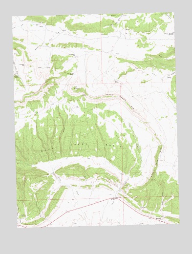
Skull Creek, CO USGS Topographic Map
Click on map above to begin viewing in our Map Viewer.

This topographic map contains these locations and features:
Feature Name Type Latitude Longitude GNIS ID View Map
Bear CanyonValleyN40.3359°W108.6355°170969View Map
Bear SpringSpringN40.3350°W108.6729°170921View Map
Bear Valley DrawValleyN40.3710°W108.6280°170745View Map
Blair SpringSpringN40.2572°W108.7437°170924View Map
Blue Mountain Number FourMineN40.2522°W108.6951°1683132View Map
Davidson SpringSpringN40.3400°W108.7476°170830View Map
Dinosaur DivisionCivilN40.3442°W108.6317°1935399View Map
Gunsight GapGapN40.3461°W108.7418°170918View Map
Jack SpringsPopulated PlaceN40.3511°W108.7032°170920View Map
Jack Springs PassGapN40.3402°W108.7043°170919View Map
Karren RanchLocaleN40.3700°W108.7301°170916View Map
Lone MountainSummitN40.3319°W108.7046°170923View Map
Luxen DrawValleyN40.3712°W108.7411°170945View Map
MassadonaPopulated PlaceN40.2527°W108.6404°170927View Map
Peterson Post Flat ReservoirReservoirN40.3619°W108.6302°170933View Map
Petes PostSummitN40.3464°W108.6287°201963View Map
Skull CreekLocaleN40.2661°W108.6729°170926View Map
Skull Creek BasinBasinN40.2944°W108.7007°201961View Map
Skull Creek RimRidgeN40.3300°W108.6518°170931View Map
Stoner SpringSpringN40.3275°W108.6984°170922View Map
Watson DrawValleyN40.3659°W108.7107°170917View Map

Note: Coordinates in the location and feature list above are referenced to NAD83 datum.


Copyright (C) 2008-2025 Ryan Niemi / Sunset Dynamics ... All Rights Reserved