TopoQuest Logo
Do you find TopoQuest useful?
Help keep TopoQuest running and adding new maps/features by donating!
Bitcoin:  19c7KJd3qBynnjoSw5npx9KScwjBe4ifkT
Litecoin:  LXs6TkuXGGXo1vDsWCkWVdjQX94eUKd6ui
Home View Maps Find Maps Find Places Resources & Links


Bay Port West, Michigan Topographic Map

USGS Map Title: Bay Port West, MI
USGS Map MRC: 43083G4
DRG (GeoTIFF) Download: o43083g4.tif


Neighboring USGS Topographic Map Quads:


  Sand Point, MI  
43083H4
 

  Caseville, MI  
43083H3


  Bay Port West, MI  
43083G4
 

  Bay Port East, MI  
43083G3
 

  Fish Point, MI  
43083F5
 

  Sebewaing, MI  
43083F4
 

  Owendale, MI  
43083F3


Map MRC Location:

N44°
W84°
N44°
W83°
H8 H7 H6 H5 H4 H3 H2 H1
G8 G7 G6 G5 G4 G3 G2 G1
F8 F7 F6 F5 F4 F3 F2 F1
E8 E7 E6 E5 E4 E3 E2 E1
D8 D7 D6 D5 D4 D3 D2 D1
C8 C7 C6 C5 C4 C3 C2 C1
B8 B7 B6 B5 B4 B3 B2 B1
A8 A7 A6 A5 A4 A3 A2 A1
N43°
W84°
N43°
W83°

Bay Port West, MI USGS 1:24K Topographic Map Preview:
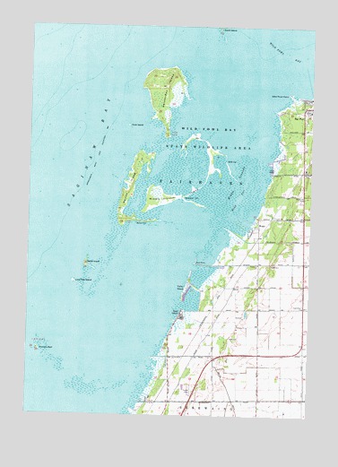
Bay Port West, MI USGS Topographic Map
Click on map above to begin viewing in our Map Viewer.

This topographic map contains these locations and features:
Feature Name Type Latitude Longitude GNIS ID View Map
Bay Port CemeteryCemeteryN43.8281°W83.3769°620790View Map
Bay Port Police DepartmentBuildingN43.8492°W83.3786°2548479View Map
Bayside Estates Mobile Home ParkPopulated PlaceN43.7583°W83.4278°2548351View Map
Blind PassChannelN43.8197°W83.4061°621584View Map
Boxcar CutChannelN43.8133°W83.4514°621813View Map
Community of Christ ChurchChurchN43.8483°W83.3775°2548489View Map
Defoe IslandIslandN43.7981°W83.4739°624508View Map
Duck IslandIslandN43.8428°W83.4552°624920View Map
Dynamite CutChannelN43.8203°W83.4316°625066View Map
Fairhaven ChurchChurchN43.7989°W83.3977°625753View Map
Fairhaven Township Fire DepartmentBuildingN43.8484°W83.3751°2548490View Map
Faith Bible ChurchChurchN43.7853°W83.3775°625789View Map
Great Fire of 1881 Historical MarkerParkN43.8206°W83.3772°2548589View Map
Heisterman IslandIslandN43.8542°W83.4389°628058View Map
Henne DrainCanalN43.7922°W83.3955°628108View Map
Lone Tree IslandIslandN43.7925°W83.4786°630896View Map
Maisou IslandIslandN43.8208°W83.4569°631340View Map
Middle GroundsSwampN43.8233°W83.4083°632250View Map
Middle Grounds IslandIslandN43.8292°W83.4194°632251View Map
North IslandIslandN43.8747°W83.4161°1617389View Map
Pitchers ReefIslandN43.7689°W83.4902°635054View Map
Rose IslandPopulated PlaceN43.7828°W83.4314°636201View Map
Rush CutChannelN43.8325°W83.4122°636387View Map
Sanford Brown Roadside ParkParkN43.8203°W83.3778°2548485View Map
Shebeon CreekStreamN43.8100°W83.4111°637702View Map
Tarry Post Office (historical)Post OfficeN43.7842°W83.4167°2548503View Map
Tarry Station (historical)LocaleN43.7842°W83.4169°2548459View Map
Valley IslandPopulated PlaceN43.7922°W83.4280°1615452View Map
WealePopulated PlaceN43.8120°W83.3972°1617924View Map
Wild Fowl Bay State ParkParkN43.8395°W83.4205°1616458View Map
Wild Fowl PointCapeN43.8533°W83.3850°1616459View Map
WWMI-FM (Sebewaing)TowerN43.8003°W83.3938°1625500View Map

Note: Coordinates in the location and feature list above are referenced to NAD83 datum.


Copyright (C) 2008-2024 Ryan Niemi / Sunset Dynamics ... All Rights Reserved