TopoQuest Logo
Do you find TopoQuest useful?
Help keep TopoQuest running and adding new maps/features by donating!
Bitcoin:  19c7KJd3qBynnjoSw5npx9KScwjBe4ifkT
Litecoin:  LXs6TkuXGGXo1vDsWCkWVdjQX94eUKd6ui
Home View Maps Find Maps Find Places Resources & Links


Madison, Minnesota Topographic Map

USGS Map Title: Madison, MN
USGS Map MRC: 45096A2
DRG (GeoTIFF) Download: o45096a2.tif


Neighboring USGS Topographic Map Quads:


  Bellingham, MN  
45096B3
 

  Correll, MN  
45096B2
 

  Appleton, MN  
45096B1
 

  Haydenville, MN  
45096A3
 

  Madison, MN  
45096A2
 

  Cerro Gordo, MN  
45096A1
 

  Mount Wickham, MN  
44096H3
 

  Dawson NW, MN  
44096H2
 

  Dawson, MN  
44096H1


Map MRC Location:

N46°
W97°
N46°
W96°
H8 H7 H6 H5 H4 H3 H2 H1
G8 G7 G6 G5 G4 G3 G2 G1
F8 F7 F6 F5 F4 F3 F2 F1
E8 E7 E6 E5 E4 E3 E2 E1
D8 D7 D6 D5 D4 D3 D2 D1
C8 C7 C6 C5 C4 C3 C2 C1
B8 B7 B6 B5 B4 B3 B2 B1
A8 A7 A6 A5 A4 A3 A2 A1
N45°
W97°
N45°
W96°

Madison, MN USGS 1:24K Topographic Map Preview:
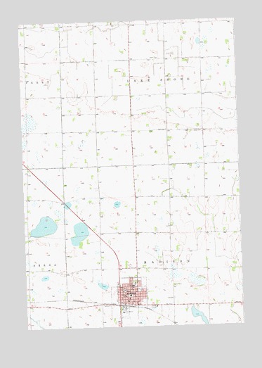
Madison, MN USGS Topographic Map
Click on map above to begin viewing in our Map Viewer.

This topographic map contains these locations and features:
Feature Name Type Latitude Longitude GNIS ID View Map
Calvary Baptist ChurchChurchN45.0167°W96.1950°2065816View Map
Calvary Baptist ChurchChurchN45.0167°W96.1950°2066453View Map
Circle B Elder Care CenterHospitalN45.0111°W96.1828°2065821View Map
Circle B Elder Care CenterHospitalN45.0111°W96.1828°2066458View Map
City of MadisonCivilN45.0128°W96.1889°2395807View Map
Congregational ChurchChurchN45.0144°W96.1917°2065818View Map
Faith CemeteryCemeteryN45.0116°W96.1645°643532View Map
Faith Lutheran ChurchChurchN45.0167°W96.1861°2065819View Map
Faith Lutheran ChurchChurchN45.0167°W96.1861°2066456View Map
Hegre CemeteryCemeteryN45.0805°W96.1661°644836View Map
KLQP-FM (Madison)TowerN45.0269°W96.1878°663070View Map
Lac qui Parle Clinic at MadisonHospitalN45.0181°W96.1867°2065823View Map
Lac qui Parle Clinic at MadisonHospitalN45.0181°W96.1867°2066460View Map
Lac qui Parle County CourthouseBuildingN45.0150°W96.1925°2065809View Map
Lac qui Parle County CourthouseBuildingN45.0150°W96.1925°2066446View Map
Lac qui Parle County FairgroundsLocaleN45.0058°W96.1931°2065805View Map
Lac qui Parle County FairgroundsLocaleN45.0058°W96.1931°2066442View Map
Lac qui Parle County JailBuildingN45.0151°W96.1930°2758828View Map
Lac qui Parle County MuseumBuildingN45.0083°W96.1958°2065803View Map
Lac qui Parle County MuseumBuildingN45.0083°W96.1958°2066440View Map
Lac qui Parle County Sheriff's OfficeBuildingN45.0151°W96.1931°2065808View Map
Lac qui Parle Sheriff OfficeBuildingN45.0144°W96.1925°2066445View Map
Lacquiparle High SchoolSchoolN45.0097°W96.1956°2065824View Map
Lacquiparle High SchoolSchoolN45.0097°W96.1956°2066461View Map
MadisonPopulated PlaceN45.0097°W96.1959°647361View Map
MadisonLocaleN45.0089°W96.1931°2065804View Map
MadisonLocaleN45.0089°W96.1931°2066441View Map
Madison Ambulance ServiceBuildingN45.0090°W96.1890°2721390View Map
Madison City HallBuildingN45.0125°W96.1931°2065812View Map
Madison City HallBuildingN45.0125°W96.1931°2066449View Map
Madison Country ClubLocaleN45.0083°W96.2083°2065801View Map
Madison Country ClubLocaleN45.0083°W96.2083°2066438View Map
Madison Elementary SchoolSchoolN45.0128°W96.1894°2065825View Map
Madison Elementary SchoolSchoolN45.0128°W96.1894°2066462View Map
Madison Fire DepartmentBuildingN45.0100°W96.1943°2065806View Map
Madison Fire HallBuildingN45.0125°W96.1931°2066443View Map
Madison HospitalHospitalN45.0170°W96.1883°2065807View Map
Madison Lutheran HomeBuildingN45.0181°W96.1867°2065822View Map
Madison Lutheran HomeBuildingN45.0181°W96.1867°2066459View Map
Madison Police DepartmentBuildingN45.0151°W96.1934°2065810View Map
Madison Police DepartmentBuildingN45.0144°W96.1925°2066447View Map
Madison Post OfficePost OfficeN45.0094°W96.1950°2065813View Map
Madison Post OfficePost OfficeN45.0094°W96.1950°2066450View Map
Madison Public LibraryBuildingN45.0125°W96.1933°2065811View Map
Madison Public LibraryBuildingN45.0125°W96.1933°2066448View Map
Saint John's Lutheran ChurchChurchN45.0175°W96.1922°2065815View Map
Saint John's Lutheran ChurchChurchN45.0175°W96.1922°2066452View Map
Saint Michael's ChurchChurchN45.0114°W96.1900°2065820View Map
Saint Michael's ChurchChurchN45.0114°W96.1900°2066457View Map
Township of MadisonCivilN45.0228°W96.1648°664871View Map
United Church of ChristChurchN45.0144°W96.1967°2065817View Map
United Church of ChristChurchN45.0144°W96.1967°2066454View Map
United Methodist ChurchChurchN45.0150°W96.1883°2065814View Map
United Methodist ChurchChurchN45.0150°W96.1883°2066451View Map

Note: Coordinates in the location and feature list above are referenced to NAD83 datum.


Copyright (C) 2008-2024 Ryan Niemi / Sunset Dynamics ... All Rights Reserved