TopoQuest Logo
Do you find TopoQuest useful?
Help keep TopoQuest running and adding new maps/features by donating!
Bitcoin:  19c7KJd3qBynnjoSw5npx9KScwjBe4ifkT
Litecoin:  LXs6TkuXGGXo1vDsWCkWVdjQX94eUKd6ui
Home View Maps Find Maps Find Places Resources & Links


Madrid NW, Iowa Topographic Map

USGS Map Title: Madrid NW, IA
USGS Map MRC: 41093H8
DRG (GeoTIFF) Download: o41093h8.tif


Neighboring USGS Topographic Map Quads:


  Ogden, IA  
42094A1
 

  Boone West, IA  
42093A8
 

  Boone East, IA  
42093A7
 

  Berkley, IA  
41094H1
 

  Madrid NW, IA  
41093H8
 

  Luther, IA  
41093H7
 

  Perry, IA  
41094G1
 

  Woodward, IA  
41093G8
 

  Granger, IA  
41093G7


Map MRC Location:

N42°
W94°
N42°
W93°
H8 H7 H6 H5 H4 H3 H2 H1
G8 G7 G6 G5 G4 G3 G2 G1
F8 F7 F6 F5 F4 F3 F2 F1
E8 E7 E6 E5 E4 E3 E2 E1
D8 D7 D6 D5 D4 D3 D2 D1
C8 C7 C6 C5 C4 C3 C2 C1
B8 B7 B6 B5 B4 B3 B2 B1
A8 A7 A6 A5 A4 A3 A2 A1
N41°
W94°
N41°
W93°

Madrid NW, IA USGS 1:24K Topographic Map Preview:
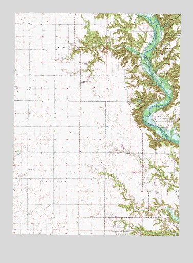
Madrid NW, IA USGS Topographic Map
Click on map above to begin viewing in our Map Viewer.

This topographic map contains these locations and features:
Feature Name Type Latitude Longitude GNIS ID View Map
Bear CreekStreamN41.9769°W93.9022°454404View Map
Bethel ChurchChurchN41.9611°W93.9497°454569View Map
Blank RidgeRidgeN41.9494°W93.9040°454686View Map
Buffalo RidgeRidgeN41.9468°W93.9090°454966View Map
Camp HantesaLocaleN41.9992°W93.8947°455120View Map
Camp MitigwaLocaleN41.9530°W93.9091°455127View Map
Davis CreekStreamN41.9950°W93.8855°455810View Map
Frankel RidgeRidgeN41.9539°W93.9109°456721View Map
James Gildea CemeteryCemeteryN41.9722°W93.8808°1996559View Map
JehuLocaleN41.9361°W93.9327°466201View Map
Jehu Post Office (historical)Post OfficeN41.9361°W93.9327°1996444View Map
KEZT-FM (Ames)TowerN41.9025°W93.9044°467080View Map
Ledges State ParkParkN41.9833°W93.8869°458266View Map
Liberty CemeteryCemeteryN41.8997°W93.8927°458315View Map
Lost LakeLakeN41.9798°W93.8946°458633View Map
Marcy (historical)LocaleN41.9994°W93.9433°466202View Map
Marcy Post Office (historical)Post OfficeN41.9994°W93.9433°1996445View Map
McCoy Wildlife AreaParkN41.9750°W93.8836°1996415View Map
Peas CreekStreamN41.9930°W93.8930°460052View Map
Peoples CemeteryCemeteryN41.9117°W93.9888°460075View Map
Pleasant Hill CemeteryCemeteryN41.9615°W93.9494°460246View Map
Prairie HillLocaleN41.9114°W93.9700°466200View Map
Prairie Hill Post Office (historical)Post OfficeN41.9222°W93.9502°1996446View Map
Shady BranchStreamN41.9808°W93.9433°465371View Map
Sparks CemeteryCemeteryN41.9728°W93.9194°461839View Map
State Hospital CemeteryCemeteryN41.8755°W93.9097°1996565View Map
Township of CassCivilN41.9027°W93.9000°467537View Map
Township of MarcyCivilN41.9900°W93.9765°468346View Map
Township of PeoplesCivilN41.9068°W93.9895°468505View Map
Turkey CreekStreamN41.9994°W93.9061°462364View Map
Worth State Game FarmParkN41.9811°W93.8891°463208View Map

Note: Coordinates in the location and feature list above are referenced to NAD83 datum.


Copyright (C) 2008-2024 Ryan Niemi / Sunset Dynamics ... All Rights Reserved