TopoQuest Logo
Do you find TopoQuest useful?
Help keep TopoQuest running and adding new maps/features by donating!
Bitcoin:  19c7KJd3qBynnjoSw5npx9KScwjBe4ifkT
Litecoin:  LXs6TkuXGGXo1vDsWCkWVdjQX94eUKd6ui
Home View Maps Find Maps Find Places Resources & Links


Manquin, Virginia Topographic Map

USGS Map Title: Manquin, VA
USGS Map MRC: 37077F2
DRG (GeoTIFF) Download: o37077f2.tif


Neighboring USGS Topographic Map Quads:


  Hanover, VA  
37077G3
 

  Beulahville, VA  
37077G2
 

  Aylett, VA  
37077G1
 

  Studley, VA  
37077F3
 

  Manquin, VA  
37077F2
 

  King William, VA  
37077F1
 

  Seven Pines, VA  
37077E3
 

  Quinton, VA  
37077E2
 

  Tunstall, VA  
37077E1


Map MRC Location:

N38°
W78°
N38°
W77°
H8 H7 H6 H5 H4 H3 H2 H1
G8 G7 G6 G5 G4 G3 G2 G1
F8 F7 F6 F5 F4 F3 F2 F1
E8 E7 E6 E5 E4 E3 E2 E1
D8 D7 D6 D5 D4 D3 D2 D1
C8 C7 C6 C5 C4 C3 C2 C1
B8 B7 B6 B5 B4 B3 B2 B1
A8 A7 A6 A5 A4 A3 A2 A1
N37°
W78°
N37°
W77°

Manquin, VA USGS 1:24K Topographic Map Preview:
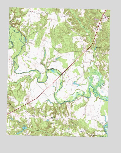
Manquin, VA USGS Topographic Map
Click on map above to begin viewing in our Map Viewer.

This topographic map contains these locations and features:
Feature Name Type Latitude Longitude GNIS ID View Map
Appersons StorePopulated PlaceN37.6360°W77.1744°1480302View Map
Appersons Store (historical)LocaleN37.6421°W77.1714°1748896View Map
Bassett BarBarN37.6724°W77.1483°1480299View Map
Bethlehem Presbyterian ChurchChurchN37.6371°W77.1905°1463239View Map
Boshers MillpondReservoirN37.7123°W77.1418°1501957View Map
Boshers Millpond DamDamN37.7113°W77.1433°1490229View Map
Carters Mill (historical)LocaleN37.7104°W77.1436°1739273View Map
Central GaragePopulated PlaceN37.7440°W77.1316°1464687View Map
Central Garage Census Designated PlaceCensusN37.7458°W77.1315°2584828View Map
Clifton DamDamN37.6401°W77.1997°1490052View Map
Curling DamDamN37.6751°W77.1614°1490212View Map
Curling PondReservoirN37.6766°W77.1651°1490213View Map
Dabneys Mill (historical)LocaleN37.7163°W77.2280°1739276View Map
Dabneys MillpondReservoirN37.7179°W77.2275°1465569View Map
Dam CreekStreamN37.6671°W77.1378°1465576View Map
Eastern ViewPopulated PlaceN37.6265°W77.1441°1477289View Map
EnfieldPopulated PlaceN37.7454°W77.2186°1477307View Map
Farmers Shop CornerPopulated PlaceN37.6421°W77.1953°1466496View Map
Francis Broaddus DamDamN37.6618°W77.1980°1490053View Map
Glimpses CornerPopulated PlaceN37.6301°W77.1550°1495597View Map
Gloucester County Regional Alternative SchoolSchoolN37.7421°W77.1301°2465284View Map
HanovertownPopulated PlaceN37.6974°W77.2466°1477392View Map
Hollyfield PondReservoirN37.6766°W77.1651°1468163View Map
HorseshoePopulated PlaceN37.6635°W77.1486°1495718View Map
Immanuel ChurchChurchN37.6429°W77.2161°1468449View Map
Jackpen CreekStreamN37.7110°W77.1453°1468576View Map
Judy SwampStreamN37.7140°W77.2305°1468894View Map
King William High SchoolSchoolN37.7423°W77.1304°1469012View Map
ManquinPopulated PlaceN37.7101°W77.1528°1470054View Map
Manquin Post OfficePost OfficeN37.7084°W77.1556°2766471View Map
McKendree Methodist ChurchChurchN37.7449°W77.2058°1470270View Map
McKendree Methodist Church CemeteryCemeteryN37.7446°W77.2069°1956571View Map
Mehixen CreekStreamN37.7307°W77.2483°1470347View Map
Moncuin CreekStreamN37.6696°W77.1430°1462308View Map
Mount Zion ChurchChurchN37.6418°W77.1883°1471137View Map
Old ChurchPopulated PlaceN37.6446°W77.2211°1471833View Map
Old Church Community CenterLocaleN37.6279°W77.1689°1471834View Map
Pampatike LandingLocaleN37.6674°W77.1364°1496059View Map
Pamunkey (historical)Populated PlaceN37.6693°W77.2041°1748919View Map
Pamunkey Regional Library Upper King William Branch LibraryBuildingN37.7390°W77.1336°2520467View Map
Pamunkey River BridgeBridgeN37.6854°W77.1833°1472038View Map
Queenfield Golf ClubLocaleN37.7064°W77.1939°2520192View Map
RetreatLocaleN37.6385°W77.1316°1473154View Map
Rock Spring ChurchChurchN37.7449°W77.2019°1473393View Map
Sharon Baptist ChurchChurchN37.7415°W77.1328°1474446View Map
Sharon Baptist Church CemeteryCemeteryN37.7418°W77.1325°1956573View Map
Skidmore BarBarN37.6668°W77.1539°1480301View Map
Spring BarBarN37.6615°W77.1297°1480300View Map
The IslandIslandN37.6821°W77.1430°1475583View Map
The MeadowsSwampN37.6659°W77.1411°1475590View Map
Totopotomoy CreekStreamN37.6854°W77.2091°1475795View Map
Townsends Dam Number OneDamN37.7001°W77.1914°1490228View Map
Townsends Dam Number TwoDamN37.7035°W77.2047°1490227View Map
Webb CreekStreamN37.7499°W77.1769°1474223View Map
Wests DamDamN37.6324°W77.2244°1490043View Map
Wests PondReservoirN37.6289°W77.2307°1502156View Map
Wests PondReservoirN37.6318°W77.2197°1502270View Map
Whiting SwampStreamN37.6349°W77.1300°1476682View Map
Wrights DamDamN37.6385°W77.2430°1490023View Map
Wrights PondReservoirN37.6408°W77.2436°1490024View Map

Note: Coordinates in the location and feature list above are referenced to NAD83 datum.


Copyright (C) 2008-2025 Ryan Niemi / Sunset Dynamics ... All Rights Reserved