TopoQuest Logo
Do you find TopoQuest useful?
Help keep TopoQuest running and adding new maps/features by donating!
Bitcoin:  19c7KJd3qBynnjoSw5npx9KScwjBe4ifkT
Litecoin:  LXs6TkuXGGXo1vDsWCkWVdjQX94eUKd6ui
Home View Maps Find Maps Find Places Resources & Links


Studley, Virginia Topographic Map

USGS Map Title: Studley, VA
USGS Map MRC: 37077F3
DRG (GeoTIFF) Download: o37077f3.tif


Neighboring USGS Topographic Map Quads:


  Ashland, VA  
37077G4
 

  Hanover, VA  
37077G3
 

  Beulahville, VA  
37077G2
 

  Yellow Tavern, VA  
37077F4
 

  Studley, VA  
37077F3
 

  Manquin, VA  
37077F2
 

  Richmond, VA  
37077E4
 

  Seven Pines, VA  
37077E3
 

  Quinton, VA  
37077E2


Map MRC Location:

N38°
W78°
N38°
W77°
H8 H7 H6 H5 H4 H3 H2 H1
G8 G7 G6 G5 G4 G3 G2 G1
F8 F7 F6 F5 F4 F3 F2 F1
E8 E7 E6 E5 E4 E3 E2 E1
D8 D7 D6 D5 D4 D3 D2 D1
C8 C7 C6 C5 C4 C3 C2 C1
B8 B7 B6 B5 B4 B3 B2 B1
A8 A7 A6 A5 A4 A3 A2 A1
N37°
W78°
N37°
W77°

Studley, VA USGS 1:24K Topographic Map Preview:
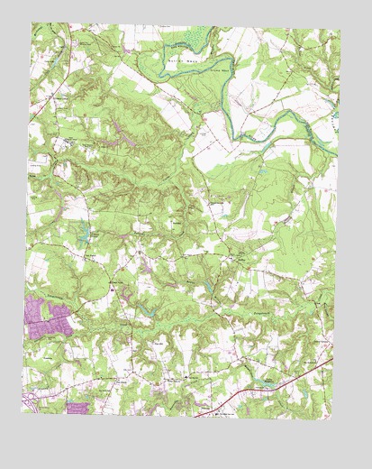
Studley, VA USGS Topographic Map
Click on map above to begin viewing in our Map Viewer.

This topographic map contains these locations and features:
Feature Name Type Latitude Longitude GNIS ID View Map
Abraham CemeteryCemeteryN37.6490°W77.3653°1462338View Map
AcademyLocaleN37.6440°W77.3664°1462346View Map
Academy CreekStreamN37.6493°W77.3578°1462348View Map
AvondalePopulated PlaceN37.6576°W77.3616°1956494View Map
Battlefield GreenPopulated PlaceN37.6282°W77.3103°1956496View Map
Battlefield Park Elementary SchoolSchoolN37.6262°W77.2964°1462833View Map
Battlefield Park Elementary School AnnexSchoolN37.6379°W77.3089°1466096View Map
Bell Creek NorthPopulated PlaceN37.6260°W77.3500°1956497View Map
BenthillPopulated PlaceN37.6879°W77.3400°1956499View Map
BuckeyePopulated PlaceN37.6874°W77.3164°1499176View Map
CadyPopulated PlaceN37.7426°W77.3619°1499207View Map
Cady CreekStreamN37.7490°W77.3683°1464235View Map
Cady LakeReservoirN37.7373°W77.3649°1464236View Map
Campbell CreekStreamN37.7443°W77.3741°1464372View Map
CherrydalePopulated PlaceN37.6260°W77.3247°1956501View Map
Cherrydale WestPopulated PlaceN37.6276°W77.3269°1956502View Map
Chestnut Grove Baptist Church CemeteryCemeteryN37.6933°W77.3012°1749001View Map
Chestnut Grove ChurchChurchN37.6935°W77.3014°1499248View Map
Colonial ForestPopulated PlaceN37.6829°W77.3547°1499287View Map
Colonial Forest DamDamN37.6835°W77.3497°1490035View Map
Colonial Forest LakeReservoirN37.6817°W77.3515°1490036View Map
Crosses CornerPopulated PlaceN37.7268°W77.3661°1465481View Map
Crossroads Christian SchoolSchoolN37.6331°W77.3397°2465407View Map
Crump CreekStreamN37.7246°W77.2972°1465495View Map
Crump NeckCapeN37.7371°W77.2978°1465496View Map
Eastern Hanover Volunteer Fire Department Meeting BuildingBuildingN37.6426°W77.2571°2331910View Map
Enon CemeteryCemeteryN37.6759°W77.3114°1749009View Map
Enon ChurchChurchN37.6763°W77.3116°1466315View Map
FieldshirePopulated PlaceN37.6301°W77.3244°1956503View Map
Fire Station Number1BuildingN37.6386°W77.3572°2086186View Map
First Union ChurchChurchN37.6365°W77.3158°1466594View Map
GeorgetownPopulated PlaceN37.6840°W77.3541°1956507View Map
Gethsemane CemeteryCemeteryN37.6346°W77.2755°1749012View Map
Gethsemane ChurchChurchN37.6349°W77.2758°1467056View Map
GreenwayPopulated PlaceN37.6960°W77.3436°1956508View Map
Guilds AcresPopulated PlaceN37.6932°W77.2858°1956509View Map
Hanover County Fire - EMS Company 3 - Eastern Hanover Volunteer Fire StationBuildingN37.6418°W77.2581°2075376View Map
Hawes MillraceStreamN37.6593°W77.2939°1467840View Map
HeatherwoodPopulated PlaceN37.6457°W77.3297°1956510View Map
Henry DistrictCivilN37.6777°W77.2766°1927339View Map
Hilly FarmsPopulated PlaceN37.6965°W77.3219°1956511View Map
Hughes CornerPopulated PlaceN37.6440°W77.2880°1749018View Map
Hundleys CornerPopulated PlaceN37.6390°W77.3303°1749019View Map
Interchange 38CrossingN37.6293°W77.3719°1749022View Map
James City Rescue SquadBuildingN37.6378°W77.3525°2086185View Map
Kersey CreekStreamN37.7035°W77.3655°1468971View Map
Linney CornersLocaleN37.6499°W77.2511°1469446View Map
Locust GreenPopulated PlaceN37.6654°W77.2616°1956512View Map
Mantilo BranchStreamN37.7107°W77.2539°1470059View Map
MattawanPopulated PlaceN37.6599°W77.3253°1956513View Map
Mattawan Association DamDamN37.6568°W77.3230°1490069View Map
Meadow GatePopulated PlaceN37.6274°W77.3525°1956514View Map
Mechanicsville Census Designated PlaceCensusN37.6263°W77.3561°2389467View Map
Millpond CreekStreamN37.7393°W77.2991°1470578View Map
Nanover Learning Center DamDamN37.7418°W77.3347°1490065View Map
Nazarene ChurchChurchN37.7182°W77.3639°1749039View Map
Nelson BridgeBridgeN37.7151°W77.2894°1471377View Map
Nelson Ferry (historical)CrossingN37.7151°W77.2894°1739290View Map
New Bethesda ChurchChurchN37.6440°W77.2566°1471398View Map
New Bethesda Church CemeteryCemeteryN37.6444°W77.2566°1749040View Map
New Chestnut Grove ChurchChurchN37.7104°W77.3497°1471406View Map
NewmanPopulated PlaceN37.6274°W77.2983°1499796View Map
Oak ForestPopulated PlaceN37.6754°W77.3516°1477584View Map
Opossum CreekStreamN37.6640°W77.3725°1474264View Map
Orchard GardensPopulated PlaceN37.6329°W77.2816°1956515View Map
Pamunkey EstatesPopulated PlaceN37.6982°W77.2811°1956516View Map
PebblebrookPopulated PlaceN37.6743°W77.3247°1956541View Map
Pebblebrook DamDamN37.6718°W77.3247°1490066View Map
Pebblebrook LakeReservoirN37.6727°W77.3260°1490067View Map
Pine HillPopulated PlaceN37.6485°W77.3222°1499868View Map
Pine Ridge FarmsLocaleN37.7076°W77.3675°1956542View Map
Pole GreenPopulated PlaceN37.6371°W77.3366°1472576View Map
Pole Green ChurchChurchN37.6326°W77.3397°1472577View Map
Pole Green Elementary SchoolSchoolN37.6398°W77.3091°2465406View Map
Pollard CreekStreamN37.7007°W77.3186°1472590View Map
Pong SwampStreamN37.6663°W77.2544°1472601View Map
Rainer DamDamN37.6651°W77.2997°1490068View Map
Rainier EstatesPopulated PlaceN37.6685°W77.2994°1956543View Map
Raven RunPopulated PlaceN37.6335°W77.3175°1956544View Map
Robertson Airport (historical)AirportN37.7054°W77.3725°1498694View Map
Robin RidgePopulated PlaceN37.6524°W77.3675°1956545View Map
Rural PointLocaleN37.6676°W77.3400°1473633View Map
Rural Point Elementary SchoolSchoolN37.6651°W77.3396°1749047View Map
Salem ChurchChurchN37.6763°W77.2919°1473953View Map
School Number 5 (historical)SchoolN37.7204°W77.3586°1749050View Map
Second Union CemeteryCemeteryN37.6769°W77.2879°1749051View Map
Second Union ChurchChurchN37.6768°W77.2880°1474151View Map
Shady Grove Church (historical)ChurchN37.6321°W77.3597°1749053View Map
Shady Grove School (historical)SchoolN37.7415°W77.2639°1739295View Map
Shannondale EstatesPopulated PlaceN37.6968°W77.3497°1956546View Map
Signal Hill Memorial ParkCemeteryN37.7439°W77.3569°1474582View Map
State Industrial SchoolSchoolN37.7121°W77.3594°1475086View Map
StrawhornPopulated PlaceN37.6490°W77.3350°1956547View Map
Strawhorn CreekStreamN37.6524°W77.3472°1475245View Map
StudleyPopulated PlaceN37.6757°W77.2908°1477787View Map
Studley FarmsPopulated PlaceN37.6718°W77.2903°1956548View Map
Studley Post OfficePost OfficeN37.6760°W77.2933°1749059View Map
Sullens CreekStreamN37.7315°W77.2544°1475303View Map
Sutton NeckCapeN37.7388°W77.3125°1475364View Map
Swannanoa EstatesPopulated PlaceN37.6565°W77.3741°1956549View Map
Talley MillpondReservoirN37.6361°W77.2770°1475441View Map
Talleys DamDamN37.6354°W77.2741°1490033View Map
The ColoniesPopulated PlaceN37.6799°W77.2891°1956550View Map
Timberlake Dam Number OneDamN37.7168°W77.3330°1490029View Map
Timberlake Dam Number TwoDamN37.7135°W77.3380°1490031View Map
Timberlake Pond Number OneReservoirN37.7168°W77.3330°1490030View Map
Timberlake Pond Number TwoReservoirN37.7129°W77.3346°1490032View Map
Virginia Department of Correctional Education - Barrett Juvenile Correctional CenterSchoolN37.7120°W77.3593°2465404View Map
Woods Farm AirstripAirportN37.7160°W77.3033°1498695View Map
WZXK-TV (Ashland)TowerN37.7424°W77.2547°1502738View Map
Zion CemeteryCemeteryN37.6398°W77.3310°1474380View Map

Note: Coordinates in the location and feature list above are referenced to NAD83 datum.


Copyright (C) 2008-2024 Ryan Niemi / Sunset Dynamics ... All Rights Reserved