TopoQuest Logo
Do you find TopoQuest useful?
Help keep TopoQuest running and adding new maps/features by donating!
Bitcoin:  19c7KJd3qBynnjoSw5npx9KScwjBe4ifkT
Litecoin:  LXs6TkuXGGXo1vDsWCkWVdjQX94eUKd6ui
Home View Maps Find Maps Find Places Resources & Links


Mapleton, Minnesota Topographic Map

USGS Map Title: Mapleton, MN
USGS Map MRC: 43093H8
DRG (GeoTIFF) Download: o43093h8.tif


Neighboring USGS Topographic Map Quads:


  Good Thunder, MN  
44094A1
 

  Beauford, MN  
44093A8
 

  Saint Clair, MN  
44093A7
 

  Sterling Center, MN  
43094H1
 

  Mapleton, MN  
43093H8
 

  Mapleton NE, MN  
43093H7
 

  Delavan, MN  
43094G1
 

  Easton, MN  
43093G8
 

  Minnesota Lake, MN  
43093G7


Map MRC Location:

N44°
W94°
N44°
W93°
H8 H7 H6 H5 H4 H3 H2 H1
G8 G7 G6 G5 G4 G3 G2 G1
F8 F7 F6 F5 F4 F3 F2 F1
E8 E7 E6 E5 E4 E3 E2 E1
D8 D7 D6 D5 D4 D3 D2 D1
C8 C7 C6 C5 C4 C3 C2 C1
B8 B7 B6 B5 B4 B3 B2 B1
A8 A7 A6 A5 A4 A3 A2 A1
N43°
W94°
N43°
W93°

Mapleton, MN USGS 1:24K Topographic Map Preview:
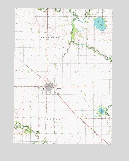
Mapleton, MN USGS Topographic Map
Click on map above to begin viewing in our Map Viewer.

This topographic map contains these locations and features:
Feature Name Type Latitude Longitude GNIS ID View Map
Beauford CemeteryCemeteryN43.9647°W93.8986°639798View Map
Boening Mobile Home ParkPopulated PlaceN43.9333°W93.9577°2051538View Map
Calvary CemeteryCemeteryN43.9261°W93.9674°640746View Map
Chase CemeteryCemeteryN43.8994°W93.9888°641127View Map
City of MapletonCivilN43.9265°W93.9546°2395842View Map
County Ditch Number FiftysevenCanalN43.9608°W93.9327°642195View Map
County Ditch Number SixteenCanalN43.9180°W93.9119°641710View Map
County Ditch Number ThirtyfiveCanalN43.8888°W93.9480°641986View Map
Cradle of Curling in Minnesota Historical MarkerParkN43.9289°W93.9561°2051647View Map
Knights LakeLakeN43.9063°W93.8884°646209View Map
Little Cobb RiverStreamN43.9919°W93.9211°646783View Map
Maple River High SchoolSchoolN43.9283°W93.9497°2051552View Map
MapletonLocaleN43.9277°W93.9536°2051548View Map
MapletonPopulated PlaceN43.9289°W93.9561°647500View Map
Mapleton Community HomeHospitalN43.9258°W93.9622°2051547View Map
Mapleton Family ClinicHospitalN43.9275°W93.9544°2051546View Map
Mapleton Fire DepartmentBuildingN43.9282°W93.9543°2051539View Map
Mapleton Historical MarkerParkN43.9339°W93.9580°2051649View Map
Mapleton Police DepartmentBuildingN43.9280°W93.9563°2051543View Map
Mapleton Post OfficePost OfficeN43.9286°W93.9530°2051545View Map
Mapleton Public LibraryBuildingN43.9280°W93.9580°2051544View Map
Mapleton Wayside ParkParkN43.9339°W93.9580°2051648View Map
Perch LakeReservoirN43.9862°W93.8916°1776126View Map
Perch Lake DamDamN43.9900°W93.8986°1776125View Map
Saint Johns Lutheran ChurchChurchN43.9280°W93.9588°2051549View Map
Saint Theresa Catholic ChurchChurchN43.9283°W93.9588°2051551View Map
Township of BeaufordCivilN43.9785°W93.9484°663534View Map
Township of MapletonCivilN43.8901°W93.9480°664908View Map
Union CemeteryCemeteryN43.9283°W93.9641°653491View Map
United Church of MapletonChurchN43.9258°W93.9605°2051550View Map

Note: Coordinates in the location and feature list above are referenced to NAD83 datum.


Copyright (C) 2008-2025 Ryan Niemi / Sunset Dynamics ... All Rights Reserved