TopoQuest Logo
Do you find TopoQuest useful?
Help keep TopoQuest running and adding new maps/features by donating!
Bitcoin:  19c7KJd3qBynnjoSw5npx9KScwjBe4ifkT
Litecoin:  LXs6TkuXGGXo1vDsWCkWVdjQX94eUKd6ui
Home View Maps Find Maps Find Places Resources & Links


Minnesota Lake, Minnesota Topographic Map

USGS Map Title: Minnesota Lake, MN
USGS Map MRC: 43093G7
DRG (GeoTIFF) Download: o43093g7.tif


Neighboring USGS Topographic Map Quads:


  Mapleton, MN  
43093H8
 

  Mapleton NE, MN  
43093H7
 

  Waldorf, MN  
43093H6
 

  Easton, MN  
43093G8
 

  Minnesota Lake, MN  
43093G7
 

  Matawan, MN  
43093G6
 

  Oza Tanka Lakebed, MN  
43093F8
 

  Brush Creek, MN  
43093F7
 

  Wells, MN  
43093F6


Map MRC Location:

N44°
W94°
N44°
W93°
H8 H7 H6 H5 H4 H3 H2 H1
G8 G7 G6 G5 G4 G3 G2 G1
F8 F7 F6 F5 F4 F3 F2 F1
E8 E7 E6 E5 E4 E3 E2 E1
D8 D7 D6 D5 D4 D3 D2 D1
C8 C7 C6 C5 C4 C3 C2 C1
B8 B7 B6 B5 B4 B3 B2 B1
A8 A7 A6 A5 A4 A3 A2 A1
N43°
W94°
N43°
W93°

Minnesota Lake, MN USGS 1:24K Topographic Map Preview:
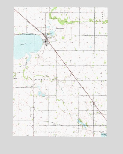
Minnesota Lake, MN USGS Topographic Map
Click on map above to begin viewing in our Map Viewer.

This topographic map contains these locations and features:
Feature Name Type Latitude Longitude GNIS ID View Map
B & D Flyers International AirportAirportN43.8309°W93.8362°660298View Map
City of Minnesota LakeCivilN43.8409°W93.8278°2395349View Map
County Ditch Number EightyfiveCanalN43.8177°W93.7988°642347View Map
County Ditch Number SeventysevenCanalN43.7958°W93.7888°642306View Map
Kremer House Library and MuseumBuildingN43.8419°W93.8322°2049188View Map
Maple River East Middle SchoolSchoolN43.8377°W93.8313°2049194View Map
Minnesota LakeLakeN43.8376°W93.8608°647939View Map
Minnesota LakePopulated PlaceN43.8419°W93.8319°647940View Map
Minnesota LakeLocaleN43.8458°W93.8336°2049192View Map
Minnesota Lake Ambulance ServiceBuildingN43.8401°W93.8326°2721314View Map
Minnesota Lake Fire DepartmentBuildingN43.8399°W93.8326°2666252View Map
Minnesota Lake Police DepartmentBuildingN43.8458°W93.8331°2049189View Map
Minnesota Lake Post OfficePost OfficeN43.8419°W93.8322°2049187View Map
Oak Grove CemeteryCemeteryN43.8483°W93.8283°648793View Map
Oak Grove CemeteryCemeteryN43.8486°W93.8283°2051630View Map
Peace CemeteryCemeteryN43.8494°W93.8283°649198View Map
Peace CemeteryCemeteryN43.8497°W93.8283°2051628View Map
Peace United Church of ChristChurchN43.8400°W93.8319°2049190View Map
Saint John Baptist Catholic ChurchChurchN43.8386°W93.8333°2049191View Map
Saint John CemeteryCemeteryN43.8486°W93.8272°2051629View Map
Saint John CemeteryCemeteryN43.8488°W93.8269°650633View Map
Saint Paul's CemeteryCemeteryN43.8186°W93.7772°2049249View Map
Saint Pauls ChurchChurchN43.8191°W93.7769°650992View Map
Schermerhorn CemeteryCemeteryN43.7777°W93.8586°2049248View Map
Stokman State Wildlife Management AreaParkN43.8544°W93.8211°652657View Map
Stokman State Wildlife Management AreaParkN43.8541°W93.8211°2051627View Map
Township of Minnesota LakeCivilN43.8022°W93.8278°664995View Map
Trahm's Farm CemeteryCemeteryN43.8625°W93.7599°2051231View Map
Zions CemeteryCemeteryN43.8300°W93.7680°654497View Map

Note: Coordinates in the location and feature list above are referenced to NAD83 datum.


Copyright (C) 2008-2024 Ryan Niemi / Sunset Dynamics ... All Rights Reserved