TopoQuest Logo
Do you find TopoQuest useful?
Help keep TopoQuest running and adding new maps/features by donating!
Bitcoin:  19c7KJd3qBynnjoSw5npx9KScwjBe4ifkT
Litecoin:  LXs6TkuXGGXo1vDsWCkWVdjQX94eUKd6ui
Home View Maps Find Maps Find Places Resources & Links


Maramec Spring, Missouri Topographic Map

USGS Map Title: Maramec Spring, MO
USGS Map MRC: 37091H5
DRG (GeoTIFF) Download: o37091h5.tif


Neighboring USGS Topographic Map Quads:


  Safe, MO  
38091A6
 

  Rosati, MO  
38091A5
 

  Cuba, MO  
38091A4
 

  Dillon, MO  
37091H6
 

  Maramec Spring, MO  
37091H5
 

  Indian Springs, MO  
37091H4
 

  Lecoma, MO  
37091G6
 

  Seaton, MO  
37091G5
 

  Cook Station, MO  
37091G4


Map MRC Location:

N38°
W92°
N38°
W91°
H8 H7 H6 H5 H4 H3 H2 H1
G8 G7 G6 G5 G4 G3 G2 G1
F8 F7 F6 F5 F4 F3 F2 F1
E8 E7 E6 E5 E4 E3 E2 E1
D8 D7 D6 D5 D4 D3 D2 D1
C8 C7 C6 C5 C4 C3 C2 C1
B8 B7 B6 B5 B4 B3 B2 B1
A8 A7 A6 A5 A4 A3 A2 A1
N37°
W92°
N37°
W91°

Maramec Spring, MO USGS 1:24K Topographic Map Preview:
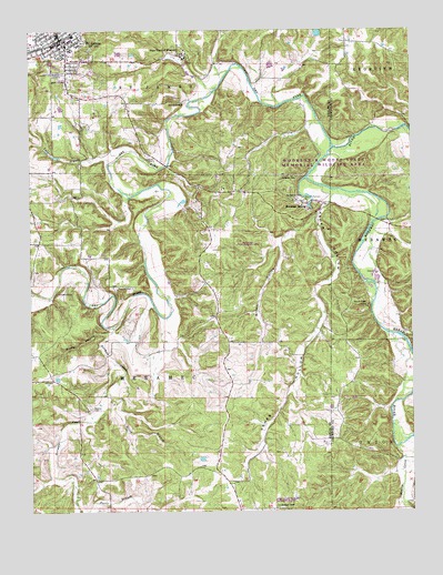
Maramec Spring, MO USGS Topographic Map
Click on map above to begin viewing in our Map Viewer.

This topographic map contains these locations and features:
Feature Name Type Latitude Longitude GNIS ID View Map
Adams CemeteryCemeteryN37.9017°W91.6057°713142View Map
Adams School (historical)SchoolN37.9014°W91.6068°744578View Map
Asher HollowValleyN37.9550°W91.5279°713432View Map
Asher Hollow School (historical)SchoolN37.9084°W91.5404°744581View Map
Asher Lookout TowerTowerN37.8767°W91.5440°754991View Map
Asher State Wildlife Management AreaParkN37.8767°W91.5432°742919View Map
Bedell LakeReservoirN37.9801°W91.6150°765293View Map
Bedell Lake DamDamN37.9784°W91.6135°765292View Map
Benton CreekStreamN37.8917°W91.5057°713966View Map
Boys Town of MissouriPopulated PlaceN37.9931°W91.5743°755006View Map
Brown HollowValleyN37.9520°W91.5313°714780View Map
De Camp (historical)Populated PlaceN37.9000°W91.5954°740040View Map
De Camp MineMineN37.8842°W91.6063°744580View Map
Dry ForkStreamN37.9695°W91.5254°754971View Map
Dry Fork State Wildlife AreaParkN37.9434°W91.5535°742920View Map
Earle BranchStreamN37.8759°W91.6096°717240View Map
Elliot BranchStreamN37.9050°W91.5990°717480View Map
First Church of GodChurchN37.9971°W91.6244°2070692View Map
Gorman CemeteryCemeteryN37.9879°W91.5740°2723841View Map
Green AirfieldAirportN37.9435°W91.6015°2679384View Map
Hawkins CemeteryCemeteryN37.9664°W91.5843°719235View Map
Howerton (historical)LocaleN37.8753°W91.5863°740464View Map
Immaculate Conception Catholic CemeteryCemeteryN37.9962°W91.6119°2723862View Map
Immaculate Conception Catholic ChurchChurchN37.9959°W91.6124°744606View Map
James MineMineN37.9778°W91.6040°744574View Map
Lake SciotoReservoirN37.9913°W91.6173°763709View Map
Lake Scioto DamDamN37.9917°W91.6202°763708View Map
Luther BranchStreamN37.9656°W91.5993°721684View Map
Maramec CemeteryCemeteryN37.9611°W91.5426°721851View Map
Maramec SpringSpringN37.9539°W91.5329°721852View Map
McDole CemeteryCemeteryN37.9509°W91.5374°2724169View Map
Meramec Springs (historical)Populated PlaceN37.9553°W91.5349°740041View Map
Mosselle MineMineN37.9789°W91.6035°744573View Map
Moty LakeReservoirN37.9996°W91.5302°763920View Map
Moty Lake DamDamN37.9967°W91.5302°763919View Map
Mound Ridge CampLocaleN37.9281°W91.5146°722695View Map
Mount Pisgah Church (historical)ChurchN37.9167°W91.5154°746815View Map
Norman CreekStreamN37.9245°W91.5957°723421View Map
Normans HollowValleyN37.9245°W91.5957°759574View Map
Old Iron FurnaceLocaleN37.9559°W91.5343°729592View Map
Old Saint James CemeteryCemeteryN37.9946°W91.6093°2559154View Map
Pine Hill CemeteryCemeteryN37.9331°W91.5913°724380View Map
Piney HollowValleyN37.9214°W91.5996°724404View Map
Pinnacles Bluff ArchArchN37.9917°W91.5561°2680508View Map
Reed Bank MineMineN37.8917°W91.6179°744579View Map
Roster School (historical)SchoolN37.9573°W91.5529°744582View Map
Saint JamesPopulated PlaceN37.9973°W91.6143°729639View Map
Saint James Cemetery CorporationCemeteryN37.9889°W91.6152°2558434View Map
Saint James City Police DepartmentBuildingN37.9967°W91.6183°2752479View Map
Saint James Fire Protection DistrictBuildingN37.9964°W91.6189°2620264View Map
Saint James Post OfficePost OfficeN37.9969°W91.6176°2779447View Map
St James Natural BridgeArchN37.9811°W91.5750°755334View Map
Swyers School (historical)SchoolN37.9873°W91.5490°744583View Map
Township of MeramecCivilN37.8757°W91.5815°767181View Map
Tripoli Valley DamDamN37.9200°W91.5302°764082View Map
Tripoli Valley LakeReservoirN37.9200°W91.5302°764083View Map
VileanLocaleN37.8792°W91.5590°735997View Map
Walnut Hill LakeReservoirN37.9917°W91.5468°765131View Map
Walnut Hill Lake DamDamN37.9917°W91.5468°765130View Map
Wayman-Fuhring Lake DamDamN37.9934°W91.5952°765511View Map
Wolfe School (historical)SchoolN37.9164°W91.5868°744577View Map
Zion Hill Church (historical)ChurchN37.9453°W91.6210°744575View Map
Zion Hill School (historical)SchoolN37.9448°W91.6124°744576View Map

Note: Coordinates in the location and feature list above are referenced to NAD83 datum.


Copyright (C) 2008-2024 Ryan Niemi / Sunset Dynamics ... All Rights Reserved