TopoQuest Logo
Do you find TopoQuest useful?
Help keep TopoQuest running and adding new maps/features by donating!
Bitcoin:  19c7KJd3qBynnjoSw5npx9KScwjBe4ifkT
Litecoin:  LXs6TkuXGGXo1vDsWCkWVdjQX94eUKd6ui
Home View Maps Find Maps Find Places Resources & Links


Seaton, Missouri Topographic Map

USGS Map Title: Seaton, MO
USGS Map MRC: 37091G5
DRG (GeoTIFF) Download: o37091g5.tif


Neighboring USGS Topographic Map Quads:


  Dillon, MO  
37091H6
 

  Maramec Spring, MO  
37091H5
 

  Indian Springs, MO  
37091H4
 

  Lecoma, MO  
37091G6
 

  Seaton, MO  
37091G5
 

  Cook Station, MO  
37091G4
 

  Anutt, MO  
37091F6
 

  Salem, MO  
37091F5
 

  Short Bend, MO  
37091F4


Map MRC Location:

N38°
W92°
N38°
W91°
H8 H7 H6 H5 H4 H3 H2 H1
G8 G7 G6 G5 G4 G3 G2 G1
F8 F7 F6 F5 F4 F3 F2 F1
E8 E7 E6 E5 E4 E3 E2 E1
D8 D7 D6 D5 D4 D3 D2 D1
C8 C7 C6 C5 C4 C3 C2 C1
B8 B7 B6 B5 B4 B3 B2 B1
A8 A7 A6 A5 A4 A3 A2 A1
N37°
W92°
N37°
W91°

Seaton, MO USGS 1:24K Topographic Map Preview:
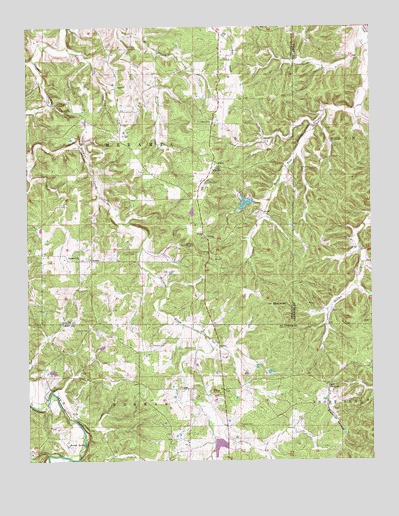
Seaton, MO USGS Topographic Map
Click on map above to begin viewing in our Map Viewer.

This topographic map contains these locations and features:
Feature Name Type Latitude Longitude GNIS ID View Map
Asher CemeteryCemeteryN37.8478°W91.5579°713430View Map
Austria (historical)Populated PlaceN37.8495°W91.5549°740039View Map
BangertPopulated PlaceN37.7712°W91.5160°740655View Map
Bell CemeteryCemeteryN37.8114°W91.5913°713900View Map
Benton Creek MineMineN37.7898°W91.5013°746819View Map
Benton-Hale CemeteryCemeteryN37.8649°W91.6087°2724151View Map
Blue KnobSummitN37.7948°W91.5368°714411View Map
Blue Mountain MineMineN37.7950°W91.5213°746818View Map
Boscobel (historical)Populated PlaceN37.7767°W91.5024°739565View Map
Brady MineMineN37.8042°W91.5563°744589View Map
Bronson MineMineN37.8081°W91.5552°744590View Map
Brown SpringSpringN37.7548°W91.6049°714791View Map
Clark MineMineN37.8184°W91.5493°744593View Map
ClintonPopulated PlaceN37.8137°W91.5596°740752View Map
Clinton Bank School (historical)SchoolN37.8142°W91.5602°744592View Map
CondrayPopulated PlaceN37.7667°W91.5549°759631View Map
Eichorst School (historical)SchoolN37.8545°W91.5546°744596View Map
Freeman CemeteryCemeteryN37.7603°W91.5488°718206View Map
Greig Hale CemeteryCemeteryN37.8609°W91.6018°2724152View Map
Grubb Andrew CemeteryCemeteryN37.8171°W91.5469°2724154View Map
Grubb CemeteryCemeteryN37.8195°W91.5449°2724153View Map
Hale BranchStreamN37.8692°W91.6096°718989View Map
Hale SchoolSchoolN37.8575°W91.5918°718993View Map
Hawkins BankMineN37.7703°W91.5577°746822View Map
Hawkins Bank School (historical)SchoolN37.7673°W91.5549°735458View Map
Highland ChurchChurchN37.8087°W91.6065°719566View Map
Highland School (historical)SchoolN37.8081°W91.6085°744588View Map
Kelly Bank MineMineN37.8620°W91.6229°744587View Map
Lay BranchStreamN37.8481°W91.5179°739564View Map
Metzger DamDamN37.7650°W91.5068°764867View Map
Morrison CemeteryCemeteryN37.7834°W91.5807°722654View Map
Nine Sixteen Bank (historical)MineN37.7600°W91.5965°746821View Map
Norman (historical)LocaleN37.8437°W91.5910°744611View Map
Perry BranchStreamN37.8748°W91.5910°724233View Map
Ryder Lake DamDamN37.7750°W91.6168°765294View Map
SeatonPopulated PlaceN37.8078°W91.6024°741253View Map
Seven Springs LakeReservoirN37.8243°W91.5460°763944View Map
Seven Springs Lake DamDamN37.8250°W91.5435°763943View Map
Smith MineMineN37.8103°W91.5599°744591View Map
Stimson MineMineN37.8514°W91.5665°744595View Map
Wards HillSummitN37.7870°W91.6046°754354View Map
Watkins SchoolSchoolN37.7723°W91.6152°746820View Map
WinklerPopulated PlaceN37.8359°W91.5571°741365View Map
Winkler MineMineN37.8359°W91.5552°744594View Map

Note: Coordinates in the location and feature list above are referenced to NAD83 datum.


Copyright (C) 2008-2024 Ryan Niemi / Sunset Dynamics ... All Rights Reserved