TopoQuest Logo
Do you find TopoQuest useful?
Help keep TopoQuest running and adding new maps/features by donating!
Bitcoin:  19c7KJd3qBynnjoSw5npx9KScwjBe4ifkT
Litecoin:  LXs6TkuXGGXo1vDsWCkWVdjQX94eUKd6ui
Home View Maps Find Maps Find Places Resources & Links


Middleburg, Virginia Topographic Map

USGS Map Title: Middleburg, VA
USGS Map MRC: 38077H6
DRG (GeoTIFF) Download: o38077h6.tif


Neighboring USGS Topographic Map Quads:


  Bluemont, VA  
39077A7
 

  Lincoln, VA  
39077A6
 

  Leesburg, VA  
39077A5
 

  Rectortown, VA  
38077H7
 

  Middleburg, VA  
38077H6
 

  Arcola, VA  
38077H5
 

  Marshall, VA  
38077G7
 

  Thoroughfare Gap, VA  
38077G6
 

  Gainesville, VA  
38077G5


Map MRC Location:

N39°
W78°
N39°
W77°
H8 H7 H6 H5 H4 H3 H2 H1
G8 G7 G6 G5 G4 G3 G2 G1
F8 F7 F6 F5 F4 F3 F2 F1
E8 E7 E6 E5 E4 E3 E2 E1
D8 D7 D6 D5 D4 D3 D2 D1
C8 C7 C6 C5 C4 C3 C2 C1
B8 B7 B6 B5 B4 B3 B2 B1
A8 A7 A6 A5 A4 A3 A2 A1
N38°
W78°
N38°
W77°

Middleburg, VA USGS 1:24K Topographic Map Preview:
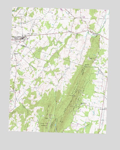
Middleburg, VA USGS Topographic Map
Click on map above to begin viewing in our Map Viewer.

This topographic map contains these locations and features:
Feature Name Type Latitude Longitude GNIS ID View Map
AldiePopulated PlaceN38.9757°W77.6414°1495187View Map
Aldie BridgeBridgeN38.9751°W77.6394°1749674View Map
Aldie DamDamN38.9776°W77.6514°1749675View Map
Aldie Elementary SchoolSchoolN38.9744°W77.6452°1749676View Map
Aldie Mill Historic ParkParkN38.9757°W77.6414°1749677View Map
Aldie Post OfficePost OfficeN38.9762°W77.6432°1749679View Map
Aldie Presbyterian CemeteryCemeteryN38.9745°W77.6427°2040861View Map
Aldie United Methodist ChurchChurchN38.9746°W77.6430°1749680View Map
Aldies MillLocaleN38.9754°W77.6414°1749678View Map
Aldred DamDamN38.8818°W77.6497°1490752View Map
Aldred PondReservoirN38.8809°W77.6515°1490753View Map
Asbury Methodist ChurchChurchN38.9721°W77.7325°1749687View Map
Ball HillSummitN38.9923°W77.7328°1749590View Map
Bartons CreekStreamN38.9432°W77.7253°1462821View Map
BowmantownPopulated PlaceN38.9515°W77.6364°1749693View Map
Browns CornerPopulated PlaceN38.9718°W77.7250°1749695View Map
Buchannon GapGapN38.9498°W77.6486°1463971View Map
Bull Run ChurchChurchN38.9001°W77.6261°1464074View Map
Bull Run Mountain EstatesPopulated PlaceN38.9037°W77.6617°1495330View Map
Bull Run Mountain Estates Census Designated PlaceCensusN38.9107°W77.6638°2629755View Map
Bull Run MountainsRangeN38.9026°W77.6742°1464077View Map
Bull Run School (historical)SchoolN38.9534°W77.6394°1749696View Map
Burnt Mill RunStreamN38.9362°W77.7336°1464137View Map
Cherry Hill DamDamN38.9901°W77.6564°1490294View Map
Cherry Hill PondReservoirN38.9901°W77.6564°1490295View Map
Church of Our RedeemerChurchN38.9751°W77.6375°1749700View Map
Cobb RunStreamN38.9759°W77.6728°1477013View Map
Cold Spring GapGapN38.9432°W77.6550°1465067View Map
DoverPopulated PlaceN38.9765°W77.6744°1495477View Map
Emmanuel Episcopal ChurchChurchN38.9693°W77.7339°1749601View Map
Evergreen Country ClubLocaleN38.8837°W77.6617°1760897View Map
Evergreen FarmsPopulated PlaceN38.8823°W77.6683°1760898View Map
Evergreen Volunteer Fire and Rescue Station 15BuildingN38.8809°W77.6344°2075229View Map
Forest Lake EstatesPopulated PlaceN38.9268°W77.6450°1760904View Map
Glenwood RacetrackLocaleN38.9937°W77.7375°1491155View Map
Grace Church (historical)ChurchN38.9123°W77.6300°1760912View Map
Griffin MountainSummitN38.8918°W77.7380°1495623View Map
HalfwayPopulated PlaceN38.9162°W77.7447°1495639View Map
Hickory GrovePopulated PlaceN38.9001°W77.6278°1495679View Map
Hickory Grove Church (historical)ChurchN38.9204°W77.6292°1760923View Map
Hickory Tree Farm AirportAirportN38.9518°W77.7470°1498746View Map
Hickory Tree Farm DamDamN38.9368°W77.7497°1489741View Map
High Acre RidgeRidgeN38.8990°W77.7000°1468004View Map
Hungry RunStreamN38.9718°W77.6553°1468384View Map
Jackson Hollow Recreation AreaParkN38.8796°W77.6897°1760930View Map
LandmarkPopulated PlaceN38.9251°W77.6878°1749280View Map
Landmark School (historical)SchoolN38.9323°W77.6928°1749281View Map
LevyPopulated PlaceN38.9421°W77.6339°1749710View Map
Long BranchStreamN38.9143°W77.7433°1469783View Map
Long Branch ChurchChurchN38.9151°W77.7447°1469796View Map
Loudoun County Fire and Rescue Aldie Volunteer Fire Department Station 7BuildingN38.9749°W77.6395°2075325View Map
Loudoun County Fire and Rescue Middleburg Volunteer Fire and Rescue Company 3BuildingN38.9681°W77.7466°2075335View Map
Memorial CemeteryCemeteryN38.9675°W77.7328°1470352View Map
Mercer ParkParkN38.9793°W77.6997°1749714View Map
Mickie Gordon Memorial ParkParkN38.9751°W77.7103°2039419View Map
MiddleburgPopulated PlaceN38.9687°W77.7355°1470422View Map
Middleburg Baptist ChurchChurchN38.9690°W77.7317°1749638View Map
Middleburg Branch Loudoun County Public LibraryBuildingN38.9687°W77.7355°1749639View Map
Middleburg Community CenterBuildingN38.9678°W77.7383°2374072View Map
Middleburg Elementary SchoolSchoolN38.9710°W77.7349°1749640View Map
Middleburg Historic DistrictParkN38.9690°W77.7355°1749641View Map
Middleburg LibraryBuildingN38.9682°W77.7408°2043120View Map
Middleburg Police DepartmentBuildingN38.9687°W77.7350°2332008View Map
Middleburg Post OfficePost OfficeN38.9680°W77.7376°1749642View Map
Mill Creek EstatesPopulated PlaceN38.8793°W77.6442°1760944View Map
Mount Pleasant CemeteryCemeteryN38.9490°W77.6425°1749715View Map
Mount Pleasant ChurchChurchN38.9490°W77.6422°1471047View Map
Mowers Dimension Stone QuarryMineN38.8917°W77.6986°2674907View Map
New Hope ForestPopulated PlaceN38.8765°W77.6555°1760948View Map
OakhamBuildingN38.9762°W77.6886°1749657View Map
Picketts CornerLocaleN38.9076°W77.7386°1749309View Map
Polecat HillSummitN38.9965°W77.7397°1496101View Map
Saint Stephens the Martyr ChurchChurchN38.9734°W77.7242°1473920View Map
Sharon CemeteryCemeteryN38.9693°W77.7306°1474436View Map
Shiloh Baptist ChurchChurchN38.9718°W77.7317°1749673View Map
Signal MountainSummitN38.8815°W77.7030°1474584View Map
SkinkertownPopulated PlaceN38.9015°W77.7425°1749340View Map
Solon CemeteryCemeteryN38.9659°W77.7434°1749664View Map
StewartownPopulated PlaceN38.9501°W77.6483°1749727View Map
StokePopulated PlaceN38.9754°W77.6664°1496260View Map
Sunny Bank (historical)Populated PlaceN38.9834°W77.7153°1749665View Map
The Hill SchoolSchoolN38.9654°W77.7350°1468051View Map
Town of MiddleburgCivilN38.9715°W77.7428°2391297View Map
White RockSummitN38.8837°W77.7044°1496406View Map
White Rock SpringSpringN38.8887°W77.6997°1476637View Map

Note: Coordinates in the location and feature list above are referenced to NAD83 datum.


Copyright (C) 2008-2024 Ryan Niemi / Sunset Dynamics ... All Rights Reserved