TopoQuest Logo
Do you find TopoQuest useful?
Help keep TopoQuest running and adding new maps/features by donating!
Bitcoin:  19c7KJd3qBynnjoSw5npx9KScwjBe4ifkT
Litecoin:  LXs6TkuXGGXo1vDsWCkWVdjQX94eUKd6ui
Home View Maps Find Maps Find Places Resources & Links


Martin, Louisiana Topographic Map

USGS Map Title: Martin, LA
USGS Map MRC: 32093A2
DRG (GeoTIFF) Download: o32093a2.tif


Neighboring USGS Topographic Map Quads:


  Hall Summit, LA  
32093B3
 

  Roy, LA  
32093B2
 

  Ashland, LA  
32093B1
 

  Coushatta, LA  
32093A3
 

  Martin, LA  
32093A2
 

  Chestnut, LA  
32093A1
 

  Hanna, LA  
31093H3
 

  Fairview Alpha, LA  
31093H2
 

  Campti, LA  
31093H1


Map MRC Location:

N33°
W94°
N33°
W93°
H8 H7 H6 H5 H4 H3 H2 H1
G8 G7 G6 G5 G4 G3 G2 G1
F8 F7 F6 F5 F4 F3 F2 F1
E8 E7 E6 E5 E4 E3 E2 E1
D8 D7 D6 D5 D4 D3 D2 D1
C8 C7 C6 C5 C4 C3 C2 C1
B8 B7 B6 B5 B4 B3 B2 B1
A8 A7 A6 A5 A4 A3 A2 A1
N32°
W94°
N32°
W93°

Martin, LA USGS 1:24K Topographic Map Preview:
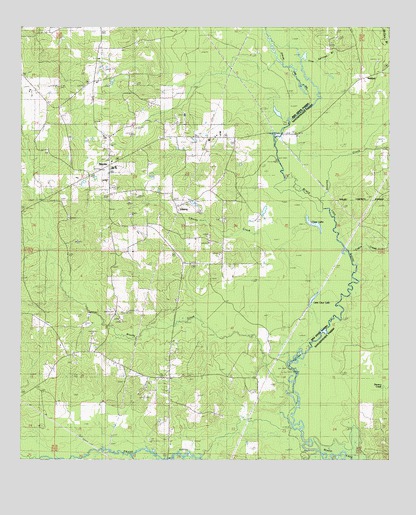
Martin, LA USGS Topographic Map
Click on map above to begin viewing in our Map Viewer.

This topographic map contains these locations and features:
Feature Name Type Latitude Longitude GNIS ID View Map
Antoine CreekStreamN32.0743°W93.1474°546979View Map
Brushy CreekStreamN32.0215°W93.1591°533473View Map
Cabin CreekStreamN32.0585°W93.1379°547160View Map
Clear LakeLakeN32.0683°W93.1509°554015View Map
Clear Springs CemeteryCemeteryN32.0877°W93.2413°548740View Map
Clear Springs ChurchChurchN32.0907°W93.2418°533995View Map
Coffeys Bridge (historical)BridgeN32.0635°W93.1427°548969View Map
Demery CreekStreamN32.0138°W93.1454°547295View Map
Grand BayouStreamN32.0074°W93.1599°535312View Map
Harvey ChurchChurchN32.0693°W93.1813°535553View Map
Hickory Grove CemeteryCemeteryN32.0279°W93.2324°548749View Map
Hickory Grove ChurchChurchN32.0279°W93.2321°535649View Map
Iron Springs BranchStreamN32.1024°W93.1527°535946View Map
Lake Village BridgeBridgeN32.0943°W93.1618°549017View Map
LibertyPopulated PlaceN32.0727°W93.1974°555033View Map
Liberty CemeteryCemeteryN32.0752°W93.1971°548750View Map
Liberty ChurchChurchN32.0752°W93.1979°548751View Map
Liberty CreekStreamN32.0752°W93.1510°536425View Map
Liberty Gas FieldOilfieldN32.0704°W93.2216°548752View Map
Little Clear LakeLakeN32.0478°W93.1498°555060View Map
MartinPopulated PlaceN32.0854°W93.2202°543448View Map
Martin CemeteryCemeteryN32.0863°W93.2207°548755View Map
Martin High SchoolSchoolN32.0932°W93.2216°548756View Map
Martin Lookout TowerTowerN32.0785°W93.2188°558803View Map
Parish Governing Authority District 2CivilN32.0890°W93.2483°1929908View Map
Pickett CemeteryCemeteryN32.0918°W93.1943°548759View Map
Robertson BranchStreamN32.0002°W93.1913°538642View Map
Salt Springs ChurchChurchN32.0238°W93.2002°539111View Map
Southwest Demery Creek Gas FieldOilfieldN32.0121°W93.1274°548923View Map
Thomas-Wren CemeteryCemeteryN32.0696°W93.1821°548766View Map
Village of MartinCivilN32.0982°W93.2193°2407496View Map
Ward OneCivilN32.0046°W93.2321°545179View Map

Note: Coordinates in the location and feature list above are referenced to NAD83 datum.


Copyright (C) 2008-2025 Ryan Niemi / Sunset Dynamics ... All Rights Reserved