TopoQuest Logo
Do you find TopoQuest useful?
Help keep TopoQuest running and adding new maps/features by donating!
Bitcoin:  19c7KJd3qBynnjoSw5npx9KScwjBe4ifkT
Litecoin:  LXs6TkuXGGXo1vDsWCkWVdjQX94eUKd6ui
Home View Maps Find Maps Find Places Resources & Links


Coushatta, Louisiana Topographic Map

USGS Map Title: Coushatta, LA
USGS Map MRC: 32093A3
DRG (GeoTIFF) Download: o32093a3.tif


Neighboring USGS Topographic Map Quads:


  East Point, LA  
32093B4
 

  Hall Summit, LA  
32093B3
 

  Roy, LA  
32093B2
 

  Harmon, LA  
32093A4
 

  Coushatta, LA  
32093A3
 

  Martin, LA  
32093A2
 

  Evelyn, LA  
31093H4
 

  Hanna, LA  
31093H3
 

  Fairview Alpha, LA  
31093H2


Map MRC Location:

N33°
W94°
N33°
W93°
H8 H7 H6 H5 H4 H3 H2 H1
G8 G7 G6 G5 G4 G3 G2 G1
F8 F7 F6 F5 F4 F3 F2 F1
E8 E7 E6 E5 E4 E3 E2 E1
D8 D7 D6 D5 D4 D3 D2 D1
C8 C7 C6 C5 C4 C3 C2 C1
B8 B7 B6 B5 B4 B3 B2 B1
A8 A7 A6 A5 A4 A3 A2 A1
N32°
W94°
N32°
W93°

Coushatta, LA USGS 1:24K Topographic Map Preview:
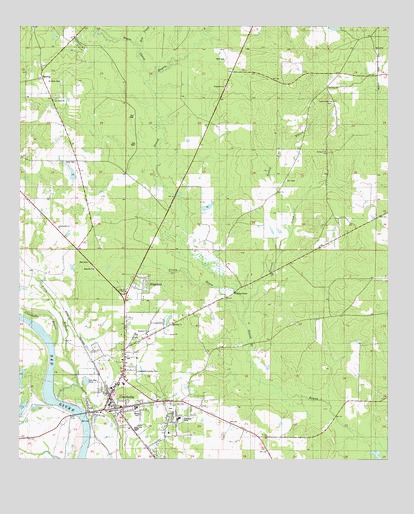
Coushatta, LA USGS Topographic Map
Click on map above to begin viewing in our Map Viewer.

This topographic map contains these locations and features:
Feature Name Type Latitude Longitude GNIS ID View Map
Adcock Pond DamDamN32.0718°W93.3102°556994View Map
Apostolic ChurchChurchN32.0396°W93.3229°532199View Map
Bayou ChicotStreamN32.1107°W93.3313°532517View Map
Beacon Church (historical)ChurchN32.0343°W93.2921°541328View Map
Carrol Creek ChurchChurchN32.1035°W93.2693°533780View Map
Carroll CreekStreamN32.0440°W93.2977°533782View Map
Christus Coushatta Health Care CenterHospitalN32.0209°W93.3437°2674107View Map
Church of ChristChurchN32.0485°W93.3391°541325View Map
Coney BayouStreamN32.0393°W93.2991°554068View Map
CoushattaPopulated PlaceN32.0149°W93.3421°1629928View Map
Coushatta Country ClubLocaleN32.0254°W93.3346°558757View Map
Coushatta Elementary SchoolSchoolN32.0141°W93.3441°548742View Map
Coushatta Oil FieldOilfieldN32.1202°W93.3563°534193View Map
Dry CreekStreamN32.1179°W93.3346°534611View Map
EdgefieldPopulated PlaceN32.0507°W93.3329°543165View Map
Elizabeth ChurchChurchN32.1077°W93.3060°534792View Map
Forked Pine BranchStreamN32.0718°W93.2818°535044View Map
Grover Lane Church (historical)ChurchN32.1115°W93.3674°541327View Map
HalfwayPopulated PlaceN32.1099°W93.3677°543271View Map
Hamilton ChurchChurchN32.0371°W93.3310°535506View Map
Hammell (historical)Populated PlaceN32.0546°W93.3710°548748View Map
Hand CemeteryCemeteryN32.0860°W93.3560°535515View Map
Hand Pond DamDamN32.0835°W93.3585°556993View Map
Jerusalem Church (historical)ChurchN32.0013°W93.3596°541324View Map
Liberty Hill ChurchChurchN32.0671°W93.3618°536427View Map
Magnolia ChurchChurchN32.0549°W93.3499°536841View Map
Martin ChurchChurchN32.1185°W93.2543°536918View Map
New Star CemeteryCemeteryN32.1029°W93.2693°541329View Map
New Star ChurchChurchN32.1074°W93.2710°537632View Map
Parish Governing Authority District 7CivilN32.0274°W93.3048°1930201View Map
Posey BranchStreamN32.0171°W93.3618°538354View Map
Red River Elementary SchoolSchoolN32.0329°W93.3331°2462753View Map
Red River Fire Protection DistrictBuildingN32.0155°W93.3419°2672869View Map
Red River Junior High SchoolSchoolN32.0148°W93.3357°2462811View Map
Red River ParishCivilN32.0931°W93.3399°559472View Map
Red River Parish CourthouseBuildingN32.0146°W93.3404°548762View Map
Red River Parish Sheriff's OfficeBuildingN32.0145°W93.3404°2755304View Map
Red River Senior High SchoolSchoolN32.0145°W93.3353°548743View Map
Saint Marys ChurchChurchN32.0893°W93.2713°538986View Map
Saint Pauls CemeteryCemeteryN32.1090°W93.3613°539035View Map
Saint Pauls ChurchChurchN32.1032°W93.3632°539042View Map
Specialty Rehabilitation HospitalBuildingN32.0287°W93.3404°2674186View Map
Springville CemeteryCemeteryN32.0146°W93.3238°548763View Map
Springville Educational Center SchoolSchoolN32.0118°W93.3210°548764View Map
Stevens Plantation (historical)LocaleN32.0113°W93.3043°1630837View Map
Town of CoushattaCivilN32.0257°W93.3406°2406325View Map
Village of EdgefieldCivilN32.0501°W93.3360°2407448View Map
Ward EightCivilN32.0177°W93.3429°545186View Map
Ward SevenCivilN32.0396°W93.3435°545185View Map
Ward SixCivilN32.0007°W93.3121°545184View Map
Ward TwoCivilN32.0993°W93.2829°545180View Map
Wesley Chapel CemeteryCemeteryN32.1102°W93.3688°548771View Map
Wesleyan ChurchChurchN32.1102°W93.3682°541326View Map

Note: Coordinates in the location and feature list above are referenced to NAD83 datum.


Copyright (C) 2008-2025 Ryan Niemi / Sunset Dynamics ... All Rights Reserved