TopoQuest Logo
Do you find TopoQuest useful?
Help keep TopoQuest running and adding new maps/features by donating!
Bitcoin:  19c7KJd3qBynnjoSw5npx9KScwjBe4ifkT
Litecoin:  LXs6TkuXGGXo1vDsWCkWVdjQX94eUKd6ui
Home View Maps Find Maps Find Places Resources & Links


Mary Esther, Florida Topographic Map

USGS Map Title: Mary Esther, FL
USGS Map MRC: 30086D6
DRG (GeoTIFF) Download: o30086d6.tif


Neighboring USGS Topographic Map Quads:


  Harold SE, FL  
30086E7
 

  Holt SW, FL  
30086E6
 

  Valparaiso, FL  
30086E5
 

  Navarre, FL  
30086D7
 

  Mary Esther, FL  
30086D6
 

  Fort Walton Beach, FL  
30086D5


Map MRC Location:

N31°
W87°
N31°
W86°
H8 H7 H6 H5 H4 H3 H2 H1
G8 G7 G6 G5 G4 G3 G2 G1
F8 F7 F6 F5 F4 F3 F2 F1
E8 E7 E6 E5 E4 E3 E2 E1
D8 D7 D6 D5 D4 D3 D2 D1
C8 C7 C6 C5 C4 C3 C2 C1
B8 B7 B6 B5 B4 B3 B2 B1
A8 A7 A6 A5 A4 A3 A2 A1
N30°
W87°
N30°
W86°

Mary Esther, FL USGS 1:24K Topographic Map Preview:
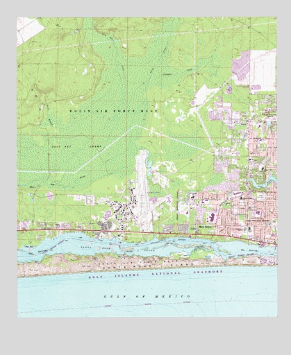
Mary Esther, FL USGS Topographic Map
Click on map above to begin viewing in our Map Viewer.

This topographic map contains these locations and features:
Feature Name Type Latitude Longitude GNIS ID View Map
Alligator CreekStreamN30.4769°W86.6844°277785View Map
Beal CemeteryCemeteryN30.4257°W86.6316°278273View Map
City of Mary EstherCivilN30.4127°W86.6588°2405034View Map
East Bay SwampSwampN30.4555°W86.7260°281950View Map
Edwins Fine and Performing Arts SchoolSchoolN30.4123°W86.6386°282116View Map
Eglin Air Force Base Fire Station Hurlburt FieldBuildingN30.4244°W86.6934°2644692View Map
Florosa Fire Department Station 5BuildingN30.4123°W86.7376°2644190View Map
Florosa SchoolSchoolN30.4135°W86.7294°282627View Map
Fort Walton Beach High SchoolSchoolN30.4120°W86.6403°282711View Map
Fort Walton Beach Medical CenterHospitalN30.4549°W86.6336°298678View Map
Fort Walton Beach Medical Center HeliportAirportN30.4538°W86.6350°309440View Map
Gulf Coast Treatment CenterBuildingN30.4559°W86.6360°2662494View Map
HarrisPopulated PlaceN30.4141°W86.7363°295050View Map
Holy Trinity ChurchChurchN30.4080°W86.6380°284209View Map
Horse BranchStreamN30.4538°W86.7291°284274View Map
Hurlburt FieldAirportN30.4274°W86.6927°309649View Map
Hurlburt FieldMilitaryN30.4276°W86.6970°2512244View Map
Kohler BayouStreamN30.4094°W86.6844°295055View Map
Lasater PointCapeN30.4083°W86.6808°285355View Map
Live Oak CreekStreamN30.4305°W86.7311°285867View Map
Mary EstherPopulated PlaceN30.4099°W86.6630°286480View Map
Mary Esther Elementary SchoolSchoolN30.4106°W86.6575°298324View Map
Mary Esther Fire DepartmentBuildingN30.4117°W86.6638°2644223View Map
Mary Esther Post OfficePost OfficeN30.4132°W86.6668°2759174View Map
Max Bruner Junior Middle SchoolSchoolN30.4189°W86.6341°298325View Map
New Heights SchoolSchoolN30.4255°W86.6650°287616View Map
Oakland ChurchChurchN30.4227°W86.6500°288010View Map
Oakland Heights SchoolSchoolN30.4249°W86.6422°288011View Map
Ocean City - Wright Fire District Station 3BuildingN30.4291°W86.6374°2644502View Map
Okaloosa County Emergency Medical Services Station 8BuildingN30.4186°W86.6707°2661712View Map
Pirate CoveLakeN30.4002°W86.6584°288990View Map
Silver Sands SchoolSchoolN30.4210°W86.6385°291135View Map
The NarrowsChannelN30.4010°W86.7488°292171View Map
Turtle CreekStreamN30.4771°W86.6844°292572View Map
WFTW-AM (Fort Walton Beach)TowerN30.4138°W86.6277°308684View Map
WKSM-FM (Fort Walton Beach)TowerN30.4144°W86.6277°308988View Map
WNUETowerN30.4230°W86.6400°295051View Map
WNUE-AM (Fort Walton Beach)TowerN30.4241°W86.6394°308687View Map
WrightPopulated PlaceN30.4558°W86.6383°293539View Map
Wright Census Designated PlaceCensusN30.4445°W86.6420°2403044View Map
Wright Elementary SchoolSchoolN30.4370°W86.6320°293545View Map

Note: Coordinates in the location and feature list above are referenced to NAD83 datum.


Copyright (C) 2008-2024 Ryan Niemi / Sunset Dynamics ... All Rights Reserved