TopoQuest Logo
Do you find TopoQuest useful?
Help keep TopoQuest running and adding new maps/features by donating!
Bitcoin:  19c7KJd3qBynnjoSw5npx9KScwjBe4ifkT
Litecoin:  LXs6TkuXGGXo1vDsWCkWVdjQX94eUKd6ui
Home View Maps Find Maps Find Places Resources & Links


Valparaiso, Florida Topographic Map

USGS Map Title: Valparaiso, FL
USGS Map MRC: 30086E5
DRG (GeoTIFF) Download: o30086e5.tif


Neighboring USGS Topographic Map Quads:


  Holt, FL  
30086F6
 

  Crestview South, FL  
30086F5
 

  Spencer Flats, FL  
30086F4
 

  Holt SW, FL  
30086E6
 

  Valparaiso, FL  
30086E5
 

  Niceville, FL  
30086E4
 

  Mary Esther, FL  
30086D6
 

  Fort Walton Beach, FL  
30086D5
 

  Destin, FL  
30086D4


Map MRC Location:

N31°
W87°
N31°
W86°
H8 H7 H6 H5 H4 H3 H2 H1
G8 G7 G6 G5 G4 G3 G2 G1
F8 F7 F6 F5 F4 F3 F2 F1
E8 E7 E6 E5 E4 E3 E2 E1
D8 D7 D6 D5 D4 D3 D2 D1
C8 C7 C6 C5 C4 C3 C2 C1
B8 B7 B6 B5 B4 B3 B2 B1
A8 A7 A6 A5 A4 A3 A2 A1
N30°
W87°
N30°
W86°

Valparaiso, FL USGS 1:24K Topographic Map Preview:
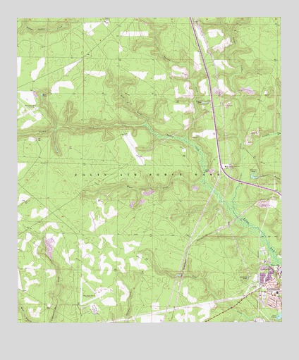
Valparaiso, FL USGS Topographic Map
Click on map above to begin viewing in our Map Viewer.

This topographic map contains these locations and features:
Feature Name Type Latitude Longitude GNIS ID View Map
Anderson BranchStreamN30.5588°W86.5186°277854View Map
Anderson PondReservoirN30.5600°W86.5133°277863View Map
Bens CreekStreamN30.5810°W86.5641°278491View Map
Blue PondLakeN30.5932°W86.6134°279052View Map
Clearwater ParkParkN30.5177°W86.5080°280557View Map
Eglin Air Force BaseMilitaryN30.5711°W86.5448°2512171View Map
Eglin Air Force Base DivisionCivilN30.5719°W86.6069°1935756View Map
Eglin Wildlife Management AreaParkN30.5627°W86.5625°293667View Map
Juniper CreekStreamN30.5452°W86.5225°284991View Map
Kendrick PondLakeN30.5181°W86.5163°285052View Map
Kepner PondLakeN30.5903°W86.5359°285064View Map
Long BranchStreamN30.5774°W86.5027°285971View Map
Ninemile CreekStreamN30.5852°W86.5002°287742View Map
Okaloosa STEMM AcademySchoolN30.5124°W86.5023°298331View Map
Parrish CreekStreamN30.5749°W86.5455°288544View Map
Rogue CreekStreamN30.5580°W86.5363°289929View Map
Sweeney CemeteryCemeteryN30.5214°W86.5052°291930View Map
Tenmile CreekStreamN30.5680°W86.5183°292114View Map
Toms CreekStreamN30.5016°W86.5033°292351View Map
ValparaisoPopulated PlaceN30.5085°W86.5027°305048View Map
Valparaiso Police DepartmentBuildingN30.5096°W86.5001°2754493View Map
Village CenterLocaleN30.5108°W86.5025°295831View Map

Note: Coordinates in the location and feature list above are referenced to NAD83 datum.


Copyright (C) 2008-2024 Ryan Niemi / Sunset Dynamics ... All Rights Reserved