TopoQuest Logo
Do you find TopoQuest useful?
Help keep TopoQuest running and adding new maps/features by donating!
Bitcoin:  19c7KJd3qBynnjoSw5npx9KScwjBe4ifkT
Litecoin:  LXs6TkuXGGXo1vDsWCkWVdjQX94eUKd6ui
Home View Maps Find Maps Find Places Resources & Links


Marydel, Maryland Topographic Map

USGS Map Title: Marydel, MD
USGS Map MRC: 39075A6
DRG (GeoTIFF) Download: o39075a6.tif


Neighboring USGS Topographic Map Quads:


  Sudlersville, MD  
39075B7
 

  Kenton, DE  
39075B6
 

  Dover, DE  
39075B5
 

  Goldsboro, MD  
39075A7
 

  Marydel, MD  
39075A6
 

  Wyoming, DE  
39075A5
 

  Denton, MD  
38075H7
 

  Burrsville, MD  
38075H6
 

  Harrington, DE  
38075H5


Map MRC Location:

N40°
W76°
N40°
W75°
H8 H7 H6 H5 H4 H3 H2 H1
G8 G7 G6 G5 G4 G3 G2 G1
F8 F7 F6 F5 F4 F3 F2 F1
E8 E7 E6 E5 E4 E3 E2 E1
D8 D7 D6 D5 D4 D3 D2 D1
C8 C7 C6 C5 C4 C3 C2 C1
B8 B7 B6 B5 B4 B3 B2 B1
A8 A7 A6 A5 A4 A3 A2 A1
N39°
W76°
N39°
W75°

Marydel, MD USGS 1:24K Topographic Map Preview:
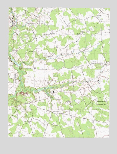
Marydel, MD USGS Topographic Map
Click on map above to begin viewing in our Map Viewer.

This topographic map contains these locations and features:
Feature Name Type Latitude Longitude GNIS ID View Map
Beachy Neidig DitchStreamN39.0826°W75.6597°213610View Map
Black SwampSwampN39.0046°W75.6505°213672View Map
Calvary United Methodist ChurchChurchN39.1126°W75.7480°595732View Map
ChapeltownPopulated PlaceN39.0998°W75.6969°216059View Map
Choptank MillsPopulated PlaceN39.0671°W75.7352°216063View Map
Cohee ProngStreamN39.0532°W75.6738°213811View Map
Cow Marsh Baptist Meeting HouseChurchN39.0373°W75.6966°214344View Map
Cow Marsh ChurchChurchN39.0421°W75.6938°213836View Map
Cow Marsh CreekStreamN39.0501°W75.7322°213837View Map
Culbreth Marsh DitchStreamN39.0715°W75.7344°213847View Map
Ditch Road DitchCanalN39.1140°W75.6555°213890View Map
Dover Bible ChapelChurchN39.1132°W75.6377°215588View Map
Fivefoot ProngStreamN39.0554°W75.6460°213963View Map
Harrington Beaverdam DitchStreamN39.1073°W75.7405°217905View Map
HazlettvillePopulated PlaceN39.1165°W75.6422°214069View Map
Horsepen DitchStreamN39.0312°W75.6827°214124View Map
Hrupsa AirportAirportN39.0019°W75.6824°2717319View Map
Immaculate Conception Catholic ChurchChurchN39.1146°W75.7491°595817View Map
Iron Mine ProngStreamN39.0518°W75.6594°214154View Map
Jackson ProngStreamN39.0493°W75.6922°214162View Map
Lords CornerPopulated PlaceN39.0146°W75.7233°216139View Map
Luther Marvel ProngStreamN39.0815°W75.6697°214260View Map
MahanPopulated PlaceN39.0659°W75.7174°216144View Map
MarydelPopulated PlaceN39.1129°W75.7458°590751View Map
MarydelPopulated PlaceN39.1123°W75.7444°214279View Map
Marydel Post OfficePost OfficeN39.1122°W75.7496°595832View Map
Marydel Volunteer Fire CompanyBuildingN39.1140°W75.7447°2131763View Map
Meredith BranchStreamN39.0473°W75.7052°214298View Map
Mount Olive CemeteryCemeteryN39.0382°W75.6980°214346View Map
Mud MillpondReservoirN39.0711°W75.7397°214356View Map
Mud MillpondLakeN39.0679°W75.7367°2089951View Map
Norman G Wilder Wildlife AreaParkN39.0362°W75.6269°213546View Map
Oak Point AcresPopulated PlaceN39.0993°W75.6613°215587View Map
Oak Point SchoolSchoolN39.1012°W75.6572°214401View Map
PetersburgPopulated PlaceN39.0493°W75.6483°216180View Map
Powell DitchStreamN39.1087°W75.6535°214485View Map
Probst Mobile Home ParkPopulated PlaceN39.1123°W75.6358°216648View Map
Ross ProngStreamN39.0904°W75.6533°214565View Map
SandtownPopulated PlaceN39.0334°W75.7188°216203View Map
Sandtown BranchStreamN39.0390°W75.7447°214608View Map
Smith CrossroadsPopulated PlaceN39.0951°W75.7158°216863View Map
Tappahanna DitchStreamN39.1073°W75.7405°214719View Map
Thomas ChapelChurchN39.0987°W75.7027°214737View Map
Tidy Island CreekStreamN39.0798°W75.7483°214746View Map
Town of MarydelCivilN39.1131°W75.7495°2391288View Map
Wildcat BranchStreamN39.0376°W75.6949°214848View Map
Willow GrovePopulated PlaceN39.0709°W75.6283°214858View Map
Willow Grove ProngStreamN39.0626°W75.6358°214860View Map
Yarema DitchCanalN39.0826°W75.7427°214886View Map
Yarema DitchCanalN39.0812°W75.7433°588364View Map

Note: Coordinates in the location and feature list above are referenced to NAD83 datum.


Copyright (C) 2008-2024 Ryan Niemi / Sunset Dynamics ... All Rights Reserved