TopoQuest Logo
Do you find TopoQuest useful?
Help keep TopoQuest running and adding new maps/features by donating!
Bitcoin:  19c7KJd3qBynnjoSw5npx9KScwjBe4ifkT
Litecoin:  LXs6TkuXGGXo1vDsWCkWVdjQX94eUKd6ui
Home View Maps Find Maps Find Places Resources & Links


Goldsboro, Maryland Topographic Map

USGS Map Title: Goldsboro, MD
USGS Map MRC: 39075A7
DRG (GeoTIFF) Download: o39075a7.tif


Neighboring USGS Topographic Map Quads:


  Church Hill, MD  
39075B8
 

  Sudlersville, MD  
39075B7
 

  Kenton, DE  
39075B6
 

  Price, MD  
39075A8
 

  Goldsboro, MD  
39075A7
 

  Marydel, MD  
39075A6
 

  Ridgely, MD  
38075H8
 

  Denton, MD  
38075H7
 

  Burrsville, MD  
38075H6


Map MRC Location:

N40°
W76°
N40°
W75°
H8 H7 H6 H5 H4 H3 H2 H1
G8 G7 G6 G5 G4 G3 G2 G1
F8 F7 F6 F5 F4 F3 F2 F1
E8 E7 E6 E5 E4 E3 E2 E1
D8 D7 D6 D5 D4 D3 D2 D1
C8 C7 C6 C5 C4 C3 C2 C1
B8 B7 B6 B5 B4 B3 B2 B1
A8 A7 A6 A5 A4 A3 A2 A1
N39°
W76°
N39°
W75°

Goldsboro, MD USGS 1:24K Topographic Map Preview:
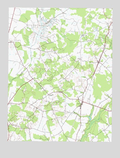
Goldsboro, MD USGS Topographic Map
Click on map above to begin viewing in our Map Viewer.

This topographic map contains these locations and features:
Feature Name Type Latitude Longitude GNIS ID View Map
Baltimore CornerPopulated PlaceN39.0582°W75.8447°589688View Map
Beaverdam DitchCanalN39.0843°W75.8727°597059View Map
Beetree DitchCanalN39.0823°W75.8274°583136View Map
Bethel ChurchChurchN39.0459°W75.8097°583179View Map
Bethel School (historical)SchoolN39.0454°W75.7841°595088View Map
BridgetownPopulated PlaceN39.0346°W75.8741°589814View Map
Bridgetown School (historical)SchoolN39.0351°W75.8727°595726View Map
Bridgetown United Methodist ChurchChurchN39.0307°W75.8216°595727View Map
Broadway BranchStreamN39.0162°W75.7744°583421View Map
Caroline Acres Mobile Home ParkPopulated PlaceN39.0687°W75.7719°595735View Map
Caroline Acres Wastewater Treatment PlantLocaleN39.0662°W75.7717°2503160View Map
Choptank Hundred (historical)CivilN39.0618°W75.8160°595746View Map
Choptank PinesPopulated PlaceN39.0057°W75.7719°595748View Map
Christ ChurchChurchN39.0762°W75.7674°595751View Map
Church of Christ in Christian UnionChurchN39.0757°W75.7674°595129View Map
Coolspring BranchStreamN39.0879°W75.7505°583887View Map
District 1, HendersonCivilN39.0778°W75.7891°1929420View Map
Edenburg DitchCanalN39.1140°W75.8224°584249View Map
Ervings Chapel (historical)ChurchN39.0109°W75.7583°595091View Map
GoldsboroPopulated PlaceN39.0340°W75.7866°590343View Map
Goldsboro Community ParkParkN39.0390°W75.7891°595784View Map
Goldsboro Post OfficePost OfficeN39.0344°W75.7871°595785View Map
Goldsboro Railroad Station (historical)BuildingN39.0351°W75.7860°595786View Map
Goldsboro Town HallBuildingN39.0357°W75.7872°595787View Map
Goldsboro Volunteer Fire Company Station 700BuildingN39.0396°W75.7886°2085689View Map
HendersonPopulated PlaceN39.0743°W75.7660°590445View Map
Henderson Community ParkParkN39.0723°W75.7602°595802View Map
Henderson Post OfficePost OfficeN39.0739°W75.7648°595803View Map
Henderson School (historical)SchoolN39.0726°W75.7616°595804View Map
Henderson United Methodist ChurchChurchN39.0762°W75.7680°595130View Map
Highland FarmLocaleN39.0176°W75.8533°595805View Map
Hollingsworth CirclePopulated PlaceN39.0437°W75.8258°595094View Map
Kane CrossroadsPopulated PlaceN39.1201°W75.8094°597624View Map
Lake BonnieReservoirN39.0225°W75.7759°594405View Map
Lake Bonnie DamDamN39.0201°W75.7763°594404View Map
Lockermon ChurchChurchN39.0148°W75.8683°585533View Map
Long MarshSwampN39.1034°W75.8372°595826View Map
Long Marsh DitchCanalN39.1112°W75.8349°597693View Map
Melville CrossroadsPopulated PlaceN39.0771°W75.7880°590788View Map
Mount ZionPopulated PlaceN39.0996°W75.7855°586050View Map
Mount Zion CemeteryCemeteryN39.0985°W75.7854°595843View Map
Mount Zion ChurchChurchN39.0998°W75.7858°595844View Map
New Union United Methodist ChurchChurchN39.0309°W75.8219°595131View Map
Oldtown BranchStreamN39.0229°W75.7772°586330View Map
Pippins Church (historical)ChurchN39.0768°W75.7883°595862View Map
Rochester CemeteryCemeteryN39.1068°W75.8556°595132View Map
School Number 1 (historical)SchoolN39.0123°W75.7569°595881View Map
School Number 1 (historical)SchoolN39.1087°W75.7555°595882View Map
School Number 2 (historical)SchoolN39.0857°W75.8191°595885View Map
Simpers Cross RoadsLocaleN39.0293°W75.8205°595898View Map
Town of GoldsboroCivilN39.0316°W75.7821°2390211View Map
Town of HendersonCivilN39.0749°W75.7661°2390240View Map
Trinity Methodist ChurchChurchN39.0343°W75.7877°595915View Map
Trinity Methodist ChurchChurchN39.0343°W75.7880°595133View Map
Union CornerLocaleN39.0276°W75.8052°595924View Map
Union CornerPopulated PlaceN39.0273°W75.8052°595134View Map
Union Memorial CemeteryCemeteryN39.0305°W75.8212°595135View Map
Wesleyan ChurchChurchN39.0371°W75.7863°595136View Map

Note: Coordinates in the location and feature list above are referenced to NAD83 datum.


Copyright (C) 2008-2024 Ryan Niemi / Sunset Dynamics ... All Rights Reserved