TopoQuest Logo
Do you find TopoQuest useful?
Help keep TopoQuest running and adding new maps/features by donating!
Bitcoin:  19c7KJd3qBynnjoSw5npx9KScwjBe4ifkT
Litecoin:  LXs6TkuXGGXo1vDsWCkWVdjQX94eUKd6ui
Home View Maps Find Maps Find Places Resources & Links


Mauckport, Indiana Topographic Map

USGS Map Title: Mauckport, IN
USGS Map MRC: 38086A2
DRG (GeoTIFF) Download: o38086a2.tif


Neighboring USGS Topographic Map Quads:


  Leavenworth, IN  
38086B3
 

  Corydon West, IN  
38086B2
 

  Corydon East, IN  
38086B1
 

  New Amsterdam, IN  
38086A3
 

  Mauckport, IN  
38086A2
 

  Laconia, IN  
38086A1
 

  Irvington, KY  
37086H3
 

  Guston, KY  
37086H2
 

  Rock Haven, KY  
37086H1


Map MRC Location:

N39°
W87°
N39°
W86°
H8 H7 H6 H5 H4 H3 H2 H1
G8 G7 G6 G5 G4 G3 G2 G1
F8 F7 F6 F5 F4 F3 F2 F1
E8 E7 E6 E5 E4 E3 E2 E1
D8 D7 D6 D5 D4 D3 D2 D1
C8 C7 C6 C5 C4 C3 C2 C1
B8 B7 B6 B5 B4 B3 B2 B1
A8 A7 A6 A5 A4 A3 A2 A1
N38°
W87°
N38°
W86°

Mauckport, IN USGS 1:24K Topographic Map Preview:
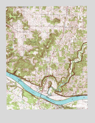
Mauckport, IN USGS Topographic Map
Click on map above to begin viewing in our Map Viewer.

This topographic map contains these locations and features:
Feature Name Type Latitude Longitude GNIS ID View Map
Atwell CemeteryCemeteryN38.0223°W86.2266°486127View Map
Boones Landing (historical)LocaleN38.0159°W86.1433°447932View Map
Buck CreekStreamN38.0153°W86.1889°431722View Map
CentralPopulated PlaceN38.0998°W86.1586°432348View Map
Crisps Crossroads (historical)LocaleN38.1142°W86.1427°449755View Map
Flippins RunStreamN38.0053°W86.1652°492258View Map
GlidasPopulated PlaceN38.0567°W86.1844°435128View Map
Hamilton HillSummitN38.0159°W86.2091°493622View Map
Haunted HollowValleyN38.0426°W86.2388°435885View Map
Hayes HillSummitN38.0703°W86.1969°435920View Map
Heth Township Fire Department Central StationBuildingN38.0986°W86.1596°2626241View Map
Heth-Washington Elementary SchoolSchoolN38.1012°W86.1750°436075View Map
Highland ChurchChurchN38.0498°W86.1875°436160View Map
John Hunt Morgans Crossing Historical MarkerParkN38.0050°W86.1694°2744604View Map
Lick RunStreamN38.0209°W86.2014°437871View Map
Matthew Welsh BridgeBridgeN38.0170°W86.1969°438730View Map
Matthew Welsh BridgeBridgeN38.0170°W86.1972°497680View Map
MauckportPopulated PlaceN38.0248°W86.2019°438737View Map
Meade County Fire Department Station 1BuildingN38.0004°W86.1769°2636663View Map
Meade County Sheriff's OfficeBuildingN38.0017°W86.1750°2767780View Map
Morgans Headquarters Historical MarkerParkN38.0043°W86.1732°2744605View Map
Morvins LandingPopulated PlaceN38.0103°W86.1675°449840View Map
Mount TomSummitN38.0823°W86.1822°444808View Map
Mount Zion ChurchChurchN38.0495°W86.1869°439746View Map
Neely Pit Number 1MineN38.0228°W86.1908°2649598View Map
Otterbein ChurchChurchN38.0234°W86.1516°440753View Map
Russell Airport (historical)AirportN38.0307°W86.2307°2444067View Map
Sand HillSummitN38.1076°W86.1683°442974View Map
Shireman HillSummitN38.0667°W86.2447°443415View Map
Solomon Brandenburg Historical MarkerParkN38.0042°W86.1692°2744603View Map
Town of MauckportCivilN38.0259°W86.1995°2396742View Map
Township of HethCivilN38.0619°W86.1799°453409View Map
Township of WashingtonCivilN38.1057°W86.2404°453999View Map
Valley CityPopulated PlaceN38.0940°W86.2228°445195View Map
Wesley ChapelChurchN38.0837°W86.2383°445693View Map
West HillPopulated PlaceN38.0039°W86.1726°2742599View Map
Wolfpen RidgeRidgeN38.1126°W86.2369°446265View Map

Note: Coordinates in the location and feature list above are referenced to NAD83 datum.


Copyright (C) 2008-2025 Ryan Niemi / Sunset Dynamics ... All Rights Reserved