TopoQuest Logo
Do you find TopoQuest useful?
Help keep TopoQuest running and adding new maps/features by donating!
Bitcoin:  19c7KJd3qBynnjoSw5npx9KScwjBe4ifkT
Litecoin:  LXs6TkuXGGXo1vDsWCkWVdjQX94eUKd6ui
Home View Maps Find Maps Find Places Resources & Links


Irvington, Kentucky Topographic Map

USGS Map Title: Irvington, KY
USGS Map MRC: 37086H3
DRG (GeoTIFF) Download: o37086h3.tif


Neighboring USGS Topographic Map Quads:


  Alton, IN  
38086A4
 

  New Amsterdam, IN  
38086A3
 

  Mauckport, IN  
38086A2
 

  Lodiburg, KY  
37086H4
 

  Irvington, KY  
37086H3
 

  Guston, KY  
37086H2
 

  Hardinsburg, KY  
37086G4
 

  Garfield, KY  
37086G3
 

  Big Spring, KY  
37086G2


Map MRC Location:

N38°
W87°
N38°
W86°
H8 H7 H6 H5 H4 H3 H2 H1
G8 G7 G6 G5 G4 G3 G2 G1
F8 F7 F6 F5 F4 F3 F2 F1
E8 E7 E6 E5 E4 E3 E2 E1
D8 D7 D6 D5 D4 D3 D2 D1
C8 C7 C6 C5 C4 C3 C2 C1
B8 B7 B6 B5 B4 B3 B2 B1
A8 A7 A6 A5 A4 A3 A2 A1
N37°
W87°
N37°
W86°

Irvington, KY USGS 1:24K Topographic Map Preview:
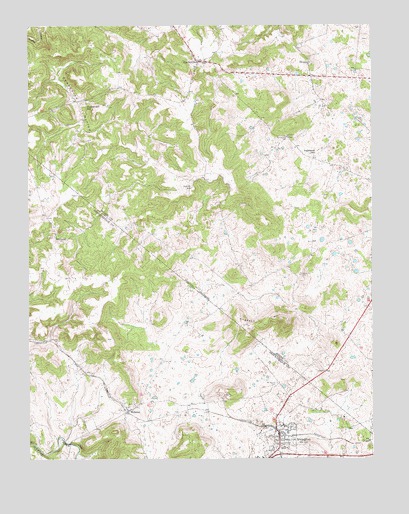
Irvington, KY USGS Topographic Map
Click on map above to begin viewing in our Map Viewer.

This topographic map contains these locations and features:
Feature Name Type Latitude Longitude GNIS ID View Map
Arnold (historical)Populated PlaceN37.9555°W86.3144°2742579View Map
Arnold SchoolSchoolN37.9531°W86.3153°486058View Map
Bunker HillSummitN37.9750°W86.3508°2742583View Map
Bunker Hill SchoolSchoolN37.9770°W86.3536°488395View Map
City of IrvingtonCivilN37.8779°W86.2847°2404767View Map
Deadhorse HollowBasinN37.9776°W86.3575°490728View Map
Fairmount SchoolSchoolN37.9623°W86.2708°491891View Map
Hogback HillSummitN37.9131°W86.2814°494355View Map
IrvingtonPopulated PlaceN37.8803°W86.2839°495028View Map
Irvington DivisionCivilN37.8952°W86.3735°1937073View Map
Irvington Police DepartmentBuildingN37.8817°W86.2842°2767747View Map
Irvington Volunteer Fire DepartmentBuildingN37.8819°W86.2842°2636401View Map
Mount Merino CemeteryCemeteryN37.8967°W86.2847°498771View Map
PaynevillePopulated PlaceN37.9895°W86.3130°500299View Map
Payneville Fire DepartmentBuildingN37.9905°W86.3113°2636887View Map
RaymondPopulated PlaceN37.9390°W86.3653°508906View Map
Richardson CemeteryCemeteryN37.9676°W86.2805°501802View Map
Sandy Hill CemeteryCemeteryN37.9281°W86.2761°502982View Map
SiroccoPopulated PlaceN37.9892°W86.2722°509065View Map
WebsterPopulated PlaceN37.8890°W86.3389°506341View Map
Webster Area Fire DepartmentBuildingN37.8894°W86.3370°2636869View Map

Note: Coordinates in the location and feature list above are referenced to NAD83 datum.


Copyright (C) 2008-2025 Ryan Niemi / Sunset Dynamics ... All Rights Reserved