TopoQuest Logo
Do you find TopoQuest useful?
Help keep TopoQuest running and adding new maps/features by donating!
Bitcoin:  19c7KJd3qBynnjoSw5npx9KScwjBe4ifkT
Litecoin:  LXs6TkuXGGXo1vDsWCkWVdjQX94eUKd6ui
Home View Maps Find Maps Find Places Resources & Links


Maxwell, New Mexico Topographic Map

USGS Map Title: Maxwell, NM
USGS Map MRC: 36104E5
DRG (GeoTIFF) Download: o36104e5.tif


Neighboring USGS Topographic Map Quads:


  Saltpeter Mountain, NM  
36104F6
 

  Koehler, NM  
36104F5
 

  Eagle Tail Mountain, NM  
36104F4
 

  Colfax, NM  
36104E6
 

  Maxwell, NM  
36104E5
 

  Loco Arroyo, NM  
36104E4
 

  Springer Lake, NM  
36104D6
 

  French, NM  
36104D5
 

  Abbott NW, NM  
36104D4


Map MRC Location:

N37°
W105°
N37°
W104°
H8 H7 H6 H5 H4 H3 H2 H1
G8 G7 G6 G5 G4 G3 G2 G1
F8 F7 F6 F5 F4 F3 F2 F1
E8 E7 E6 E5 E4 E3 E2 E1
D8 D7 D6 D5 D4 D3 D2 D1
C8 C7 C6 C5 C4 C3 C2 C1
B8 B7 B6 B5 B4 B3 B2 B1
A8 A7 A6 A5 A4 A3 A2 A1
N36°
W105°
N36°
W104°

Maxwell, NM USGS 1:24K Topographic Map Preview:
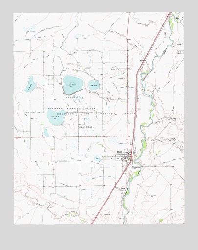
Maxwell, NM USGS Topographic Map
Click on map above to begin viewing in our Map Viewer.

This topographic map contains these locations and features:
Feature Name Type Latitude Longitude GNIS ID View Map
Crow CreekStreamN36.5992°W104.5197°888105View Map
Curtis CreekStreamN36.5900°W104.5255°888164View Map
Dam Number 13DamN36.5617°W104.5805°923894View Map
Dam Number TwoDamN36.5817°W104.6139°923896View Map
Dyke DitchCanalN36.5406°W104.5867°888603View Map
East Thirteen DitchCanalN36.5445°W104.5594°888721View Map
East Twelve DitchCanalN36.5409°W104.5778°888723View Map
Highline DitchCanalN36.5750°W104.5611°889979View Map
Kappis ArroyoStreamN36.5595°W104.5242°890628View Map
Laguna Eagle Tail LateralCanalN36.6103°W104.6092°890867View Map
Loco ArroyoStreamN36.6050°W104.5100°891245View Map
MaxwellPopulated PlaceN36.5400°W104.5433°891692View Map
Maxwell Elementary SchoolSchoolN36.5400°W104.5433°933835View Map
Maxwell Fire DepartmentBuildingN36.5398°W104.5426°2657903View Map
Maxwell First BaptistChurchN36.5400°W104.5433°920448View Map
Maxwell High SchoolSchoolN36.5400°W104.5433°901371View Map
Maxwell National Wildlife RefugeParkN36.5713°W104.5843°891693View Map
Maxwell Number 11 DamDamN36.5800°W104.6139°924067View Map
Maxwell Number 12 DamDamN36.5784°W104.5805°924068View Map
Maxwell Number 14 DamDamN36.5834°W104.5672°924069View Map
Maxwell Number 14 ReservoirReservoirN36.5819°W104.5664°924070View Map
Maxwell Post OfficePost OfficeN36.5402°W104.5422°2781534View Map
Maxwell Post Office (historical)Post OfficeN36.5400°W104.5433°938212View Map
Maxwell Weather StationLocaleN36.5400°W104.5433°932556View Map
Middle Drain DitchCanalN36.5473°W104.5447°891945View Map
North Drain DitchCanalN36.5809°W104.5467°892580View Map
North Fourteen DitchCanalN36.5886°W104.5483°892600View Map
Number 11 and Stubblefield LateralCanalN36.5239°W104.5986°898053View Map
Number 11 Inflow CanalCanalN36.5925°W104.5955°898054View Map
Number 11 LateralCanalN36.5673°W104.6178°898055View Map
Number 12 Inflow CanalCanalN36.5661°W104.6092°898057View Map
Number 14 Inflow CanalCanalN36.5906°W104.5767°898058View Map
Number 14 LateralCanalN36.5898°W104.5536°898059View Map
Number Eleven LakeLakeN36.5821°W104.6129°898355View Map
Number Fourteen lakeReservoirN36.5819°W104.5664°898358View Map
Number Thirteen LakeReservoirN36.5809°W104.5828°898357View Map
Number Twelve LakeReservoirN36.5624°W104.5951°898356View Map
Number Twenty LakeReservoirN36.5386°W104.5642°898359View Map
Red River DitchCanalN36.5950°W104.5072°893781View Map
Red River SchoolSchoolN36.6020°W104.5050°893784View Map
Reservoir Number 13ReservoirN36.5617°W104.5805°923895View Map
Reservoir Number TwoReservoirN36.5821°W104.6129°923897View Map
Ridge DitchCanalN36.5745°W104.5875°893890View Map
Siphon DitchCanalN36.6170°W104.5922°894873View Map
Siphon LateralCanalN36.6031°W104.5728°894874View Map
South Drain DitchCanalN36.5278°W104.5600°895037View Map
South Fourteen DitchCanalN36.5753°W104.5511°895059View Map
Spring ArroyoStreamN36.5489°W104.5303°895243View Map
Stubblefield Eagle Tail LateralCanalN36.5900°W104.6228°895403View Map
Village of MaxwellCivilN36.5411°W104.5430°2413571View Map
West Thirteen DitchCanalN36.5631°W104.5811°896420View Map

Note: Coordinates in the location and feature list above are referenced to NAD83 datum.


Copyright (C) 2008-2025 Ryan Niemi / Sunset Dynamics ... All Rights Reserved