TopoQuest Logo
Do you find TopoQuest useful?
Help keep TopoQuest running and adding new maps/features by donating!
Bitcoin:  19c7KJd3qBynnjoSw5npx9KScwjBe4ifkT
Litecoin:  LXs6TkuXGGXo1vDsWCkWVdjQX94eUKd6ui
Home View Maps Find Maps Find Places Resources & Links


Koehler, New Mexico Topographic Map

USGS Map Title: Koehler, NM
USGS Map MRC: 36104F5
DRG (GeoTIFF) Download: o36104f5.tif


Neighboring USGS Topographic Map Quads:


  Curtis Camp, NM  
36104G6
 

  Red River Peak, NM  
36104G5
 

  Clifton House, NM  
36104G4
 

  Saltpeter Mountain, NM  
36104F6
 

  Koehler, NM  
36104F5
 

  Eagle Tail Mountain, NM  
36104F4
 

  Colfax, NM  
36104E6
 

  Maxwell, NM  
36104E5
 

  Loco Arroyo, NM  
36104E4


Map MRC Location:

N37°
W105°
N37°
W104°
H8 H7 H6 H5 H4 H3 H2 H1
G8 G7 G6 G5 G4 G3 G2 G1
F8 F7 F6 F5 F4 F3 F2 F1
E8 E7 E6 E5 E4 E3 E2 E1
D8 D7 D6 D5 D4 D3 D2 D1
C8 C7 C6 C5 C4 C3 C2 C1
B8 B7 B6 B5 B4 B3 B2 B1
A8 A7 A6 A5 A4 A3 A2 A1
N36°
W105°
N36°
W104°

Koehler, NM USGS 1:24K Topographic Map Preview:
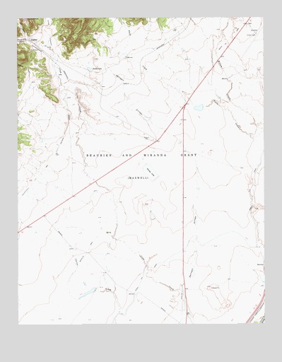
Koehler, NM USGS Topographic Map
Click on map above to begin viewing in our Map Viewer.

This topographic map contains these locations and features:
Feature Name Type Latitude Longitude GNIS ID View Map
Ashenfelder CanyonValleyN36.7211°W104.6211°885922View Map
Beardon CanyonValleyN36.7248°W104.6194°938786View Map
Crow CanyonValleyN36.7314°W104.6058°888102View Map
Crow Creek C S FarmsLocaleN36.6378°W104.5594°924608View Map
Dorsey LakeReservoirN36.6871°W104.5583°888468View Map
Eagle Tail CanalCanalN36.6503°W104.5525°888619View Map
Falls CanyonValleyN36.7481°W104.5714°888959View Map
Falls CreekStreamN36.7036°W104.5005°888960View Map
Howie (historical)LocaleN36.7145°W104.5394°902058View Map
KoehlerPopulated PlaceN36.7409°W104.6183°899697View Map
Koehler DamDamN36.7284°W104.5889°924160View Map
Koehler Junction (historical)LocaleN36.7236°W104.5989°902059View Map
Koehler LakeReservoirN36.7291°W104.5886°902283View Map
Koehler Post Office (historical)Post OfficeN36.7409°W104.6183°938293View Map
Ox CanyonValleyN36.7428°W104.6203°892988View Map
Ox Canyon MineMineN36.7495°W104.6205°916516View Map
Prairie Crow CanyonValleyN36.7411°W104.6211°893455View Map
Raton Municipal Airport/Crews FieldAirportN36.7415°W104.5022°937005View Map
Raton Trap ClubLocaleN36.7459°W104.5075°927291View Map
Springer ArroyoStreamN36.6389°W104.5428°897482View Map

Note: Coordinates in the location and feature list above are referenced to NAD83 datum.


Copyright (C) 2008-2024 Ryan Niemi / Sunset Dynamics ... All Rights Reserved