TopoQuest Logo
Do you find TopoQuest useful?
Help keep TopoQuest running and adding new maps/features by donating!
Bitcoin:  19c7KJd3qBynnjoSw5npx9KScwjBe4ifkT
Litecoin:  LXs6TkuXGGXo1vDsWCkWVdjQX94eUKd6ui
Home View Maps Find Maps Find Places Resources & Links


Ferndale, Arkansas Topographic Map

USGS Map Title: Ferndale, AR
USGS Map MRC: 34092G5
DRG (GeoTIFF) Download: o34092g5.tif


Neighboring USGS Topographic Map Quads:


  Martindale, AR  
34092H6
 

  Fourche, AR  
34092H5
 

  Mayflower, AR  
34092H4
 

  Fourche SW, AR  
34092G6
 

  Ferndale, AR  
34092G5
 

  Pinnacle Mountain, AR  
34092G4
 

  Lake Norrell, AR  
34092F6
 

  Congo, AR  
34092F5
 

  Alexander, AR  
34092F4


Map MRC Location:

N35°
W93°
N35°
W92°
H8 H7 H6 H5 H4 H3 H2 H1
G8 G7 G6 G5 G4 G3 G2 G1
F8 F7 F6 F5 F4 F3 F2 F1
E8 E7 E6 E5 E4 E3 E2 E1
D8 D7 D6 D5 D4 D3 D2 D1
C8 C7 C6 C5 C4 C3 C2 C1
B8 B7 B6 B5 B4 B3 B2 B1
A8 A7 A6 A5 A4 A3 A2 A1
N34°
W93°
N34°
W92°

Ferndale, AR USGS 1:24K Topographic Map Preview:
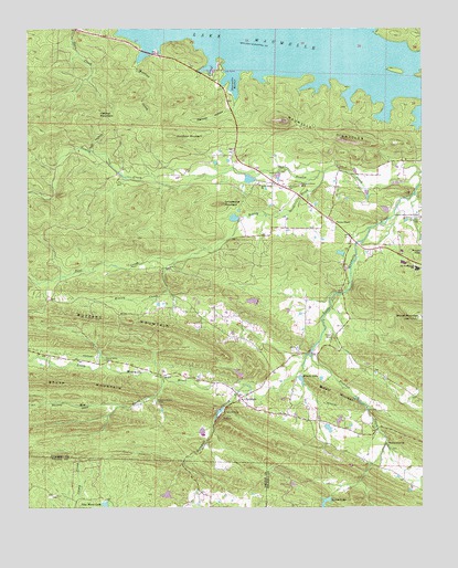
Ferndale, AR USGS Topographic Map
Click on map above to begin viewing in our Map Viewer.

This topographic map contains these locations and features:
Feature Name Type Latitude Longitude GNIS ID View Map
Alneta LakeReservoirN34.7835°W92.5386°79485View Map
Alneta Lake DamDamN34.7851°W92.5402°79484View Map
Arkansas Baptist CampLocaleN34.7779°W92.5849°45916View Map
Baldwin LakeReservoirN34.8258°W92.5598°79465View Map
Baldwin Lake DamDamN34.8251°W92.5585°79464View Map
Ball MountainSummitN34.7656°W92.5477°67421View Map
Bland HollowValleyN34.7609°W92.5171°67434View Map
Browns Valley of Rest CemeteryCemeteryN34.8268°W92.5013°47026View Map
Bufflehead Bay TrailTrailN34.8642°W92.5711°2559947View Map
Bullard MountainSummitN34.7795°W92.5274°57468View Map
Buzzard MountainRidgeN34.7990°W92.5949°76481View Map
Call HollowValleyN34.8431°W92.6054°47283View Map
Camp GrundyLocaleN34.8168°W92.5015°67442View Map
Camp OkatomaLocaleN34.7784°W92.5204°67444View Map
Dougan LakeReservoirN34.8165°W92.5259°79467View Map
Dougan Lake DamDamN34.8168°W92.5252°79466View Map
Farkleberry TrailTrailN34.8703°W92.5889°2559951View Map
Ferncliff CampLocaleN34.7751°W92.5629°49030View Map
FerndalePopulated PlaceN34.7790°W92.5577°57749View Map
Ferndale CreekStreamN34.7809°W92.5582°76919View Map
Fletcher CreekStreamN34.7895°W92.5352°49129View Map
Fletcher Spring School (historical)SchoolN34.7743°W92.5457°67503View Map
Ginger Hill LakeReservoirN34.8040°W92.5539°81145View Map
Ginger Hill Lake DamDamN34.8034°W92.5535°81144View Map
Goodson MountainSummitN34.8473°W92.5782°57834View Map
Grays LakeReservoirN34.7709°W92.5300°79489View Map
Grindstone MountainSummitN34.8295°W92.5627°57854View Map
Guenther CemeteryCemeteryN34.8256°W92.5010°49699View Map
Happy Valley LakeReservoirN34.7536°W92.5814°79320View Map
Happy Valley Lake DamDamN34.7534°W92.5835°79319View Map
Hog CreekStreamN34.7843°W92.5818°50165View Map
Joe T Robinson Elementary SchoolSchoolN34.8169°W92.5066°2039224View Map
Joe T Robinson High SchoolSchoolN34.8138°W92.5063°2039245View Map
Joe T Robinson Middle SchoolSchoolN34.8126°W92.5021°2092999View Map
Ketchel MountainSummitN34.8529°W92.6021°58016View Map
Kinley CreekStreamN34.8379°W92.5307°77409View Map
Lake New MoonReservoirN34.7510°W92.6009°79322View Map
Lake New Moon DamDamN34.7518°W92.6002°79321View Map
Lee School (historical)SchoolN34.8123°W92.5254°67560View Map
Loon ParkParkN34.8697°W92.5892°2559953View Map
Maumelle HarborBayN34.8631°W92.5588°51742View Map
Maumelle PinnaclesRidgeN34.8479°W92.5313°77615View Map
Maxwell HollowValleyN34.8568°W92.5579°51749View Map
Montgomery LakeReservoirN34.8358°W92.5550°79462View Map
Montgomery Lake DamDamN34.8368°W92.5552°79461View Map
Neal CreekStreamN34.8145°W92.5768°52585View Map
Nixon LakeReservoirN34.7518°W92.5309°79493View Map
Nixon Lake DamDamN34.7534°W92.5302°79492View Map
North Point ChurchChurchN34.8343°W92.5510°52835View Map
North Point School (historical)SchoolN34.8345°W92.5515°67608View Map
NorthpointPopulated PlaceN34.8351°W92.5518°67613View Map
Nowlin CreekStreamN34.8376°W92.5007°52854View Map
Pfeifer CampLocaleN34.7940°W92.5290°53314View Map
Pleasant Grove CemeteryCemeteryN34.8343°W92.5385°53529View Map
Protho Camp Grounds (historical)LocaleN34.8043°W92.5254°67650View Map
Pulaski County Sheriff Southwest OfficeBuildingN34.7745°W92.5428°2118775View Map
Robinson Elementary SchoolSchoolN34.8170°W92.5065°67668View Map
Robinson High SchoolSchoolN34.8140°W92.5063°67669View Map
Robinson Junior High SchoolSchoolN34.8126°W92.5021°83454View Map
Sam Gray Lake DamDamN34.7718°W92.5318°79488View Map
Slaty BranchStreamN34.7868°W92.6024°67694View Map
Spring Valley CemeteryCemeteryN34.7890°W92.6007°55127View Map
Spring Valley Church (historical)ChurchN34.7879°W92.6029°67697View Map
Sturgis Pond DamDamN34.8170°W92.5007°79468View Map
Township of Owen (historical)CivilN34.8015°W92.5349°68448View Map
Union ChapelChurchN34.8248°W92.5271°55788View Map
Walnut Grove Methodist ChurchChurchN34.7668°W92.5121°78681View Map
West Pulaski Fire Department Station 2BuildingN34.7742°W92.5440°2117303View Map
West Pulaski Fire Department Station 3BuildingN34.8204°W92.5221°2117304View Map
Wildwood CreekStreamN34.7992°W92.5322°2071419View Map
Worthen CreekStreamN34.8665°W92.5891°56549View Map

Note: Coordinates in the location and feature list above are referenced to NAD83 datum.


Copyright (C) 2008-2025 Ryan Niemi / Sunset Dynamics ... All Rights Reserved