TopoQuest Logo
Do you find TopoQuest useful?
Help keep TopoQuest running and adding new maps/features by donating!
Bitcoin:  19c7KJd3qBynnjoSw5npx9KScwjBe4ifkT
Litecoin:  LXs6TkuXGGXo1vDsWCkWVdjQX94eUKd6ui
Home View Maps Find Maps Find Places Resources & Links


Mayview, Missouri Topographic Map

USGS Map Title: Mayview, MO
USGS Map MRC: 39093A7
DRG (GeoTIFF) Download: o39093a7.tif


Neighboring USGS Topographic Map Quads:


  Lexington West, MO  
39093B8
 

  Lexington East, MO  
39093B7
 

  Dover, MO  
39093B6
 

  Odessa North, MO  
39093A8
 

  Mayview, MO  
39093A7
 

  Higginsville, MO  
39093A6
 

  Odessa South, MO  
38093H8
 

  Fayetteville, MO  
38093H7
 

  Knob Noster NW, MO  
38093H6


Map MRC Location:

N40°
W94°
N40°
W93°
H8 H7 H6 H5 H4 H3 H2 H1
G8 G7 G6 G5 G4 G3 G2 G1
F8 F7 F6 F5 F4 F3 F2 F1
E8 E7 E6 E5 E4 E3 E2 E1
D8 D7 D6 D5 D4 D3 D2 D1
C8 C7 C6 C5 C4 C3 C2 C1
B8 B7 B6 B5 B4 B3 B2 B1
A8 A7 A6 A5 A4 A3 A2 A1
N39°
W94°
N39°
W93°

Mayview, MO USGS 1:24K Topographic Map Preview:
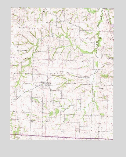
Mayview, MO USGS Topographic Map
Click on map above to begin viewing in our Map Viewer.

This topographic map contains these locations and features:
Feature Name Type Latitude Longitude GNIS ID View Map
Bertz LakeReservoirN39.0661°W93.8440°761030View Map
Brush CreekStreamN39.0858°W93.7713°714829View Map
City of MayviewCivilN39.0528°W93.8333°2395056View Map
Douthitt School (historical)SchoolN39.0170°W93.7904°747141View Map
Elm Grove School (historical)SchoolN39.0597°W93.7886°717517View Map
Fortyville (historical)Populated PlaceN39.0047°W93.8080°739830View Map
Gray Lake DamDamN39.0583°W93.7602°763515View Map
Hoeppner South Lake DamDamN39.0817°W93.8552°763519View Map
Iles Lake DamDamN39.1183°W93.7702°763525View Map
Irrigation Lake DamDamN39.0417°W93.8519°761876View Map
Lafayette C-24 LakeReservoirN39.1189°W93.7804°760417View Map
Lafayette CountyCivilN39.0656°W93.7855°758508View Map
Lake Mizzou DamDamN39.1017°W93.7502°760653View Map
Maple Glen School (historical)SchoolN39.1063°W93.8512°747140View Map
MayviewPopulated PlaceN39.0531°W93.8305°730144View Map
Mayview - Zion CemeteryCemeteryN39.0470°W93.8177°722017View Map
Mayview Fire DepartmentBuildingN39.0492°W93.8359°2620901View Map
Mayview Post OfficePost OfficeN39.0529°W93.8330°2782713View Map
Number 142 ReservoirReservoirN39.1233°W93.8119°761054View Map
Number 186 ReservoirReservoirN39.1158°W93.8665°761201View Map
Number 187 ReservoirReservoirN39.1237°W93.8603°761203View Map
Odell Lake Section 1 DamDamN39.0717°W93.8469°763518View Map
Plum Grove School (historical)SchoolN39.0814°W93.7638°724670View Map
Poole CemeteryCemeteryN39.0597°W93.7910°724743View Map
Prairie School (historical)SchoolN39.1106°W93.8024°724878View Map
Stewart LakeReservoirN39.0949°W93.7727°763523View Map
Tabo Creek Watershed Structure A-20 DamDamN39.0150°W93.8169°762809View Map
Tabo Creek Watershed Structure A-26 DamDamN39.0733°W93.7569°763516View Map
Tabo Creek Watershed Structure A-31 DamDamN39.0350°W93.8152°762808View Map
Tabo Creek Watershed Structure B-20 DamDamN39.1000°W93.8636°763520View Map
Tabo Creek Watershed Structure B-21 DamDamN39.0917°W93.8586°763521View Map
Tabo Creek Watershed Structure B-23 DamDamN39.0683°W93.8636°762799View Map
Tabo Creek Watershed Structure B-24 DamDamN39.1083°W93.8136°762804View Map
Tabo Creek Watershed Structure B-27 DamDamN39.0650°W93.8452°761029View Map
Tabo Creek Watershed Structure B-28 DamDamN39.0600°W93.8419°762807View Map
Tabo Creek Watershed Structure B-31 DamDamN39.0750°W93.8252°763541View Map
Tabo Creek Watershed Structure B-32 DamDamN39.0867°W93.8202°763517View Map
Tabo Creek Watershed Structure B-33 DamDamN39.0683°W93.7886°762802View Map
Tabo Creek Watershed Structure C-20 DamDamN39.1233°W93.8586°761202View Map
Tabo Creek Watershed Structure C-21 DamDamN39.1150°W93.8652°761200View Map
Tabo Creek Watershed Structure C-23 DamDamN39.1167°W93.8019°763524View Map
Tabo Creek Watershed Structure C-24 DamDamN39.1200°W93.7802°760416View Map
Tabo Creek Watershed Structure C-32 DamDamN39.1233°W93.8119°761053View Map
Township of WashingtonCivilN39.0010°W93.8630°766877View Map
Wegener DamDamN39.0950°W93.7736°763522View Map
Wheatly School (historical)SchoolN39.0181°W93.8499°728683View Map
Willow Branch School (historical)SchoolN39.0489°W93.7619°728938View Map

Note: Coordinates in the location and feature list above are referenced to NAD83 datum.


Copyright (C) 2008-2025 Ryan Niemi / Sunset Dynamics ... All Rights Reserved