TopoQuest Logo
Do you find TopoQuest useful?
Help keep TopoQuest running and adding new maps/features by donating!
Bitcoin:  19c7KJd3qBynnjoSw5npx9KScwjBe4ifkT
Litecoin:  LXs6TkuXGGXo1vDsWCkWVdjQX94eUKd6ui
Home View Maps Find Maps Find Places Resources & Links


McBean, Georgia Topographic Map

USGS Map Title: McBean, GA
USGS Map MRC: 33081B8
DRG (GeoTIFF) Download: o33081b8.tif


Neighboring USGS Topographic Map Quads:


  Hephzibah, GA  
33082C1
 

  Mechanic Hill, GA  
33081C8
 

  Jackson, SC  
33081C7
 

  Storys Millpond, GA  
33082B1
 

  McBean, GA  
33081B8
 

  Shell Bluff Landing, GA  
33081B7
 

  Waynesboro, GA  
33082A1
 

  Idlewood, GA  
33081A8
 

  Alexander, GA  
33081A7


Map MRC Location:

N34°
W82°
N34°
W81°
H8 H7 H6 H5 H4 H3 H2 H1
G8 G7 G6 G5 G4 G3 G2 G1
F8 F7 F6 F5 F4 F3 F2 F1
E8 E7 E6 E5 E4 E3 E2 E1
D8 D7 D6 D5 D4 D3 D2 D1
C8 C7 C6 C5 C4 C3 C2 C1
B8 B7 B6 B5 B4 B3 B2 B1
A8 A7 A6 A5 A4 A3 A2 A1
N33°
W82°
N33°
W81°

McBean, GA USGS 1:24K Topographic Map Preview:
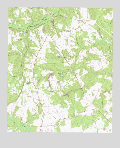
McBean, GA USGS Topographic Map
Click on map above to begin viewing in our Map Viewer.

This topographic map contains these locations and features:
Feature Name Type Latitude Longitude GNIS ID View Map
Boyd LakeReservoirN33.1851°W81.9448°337240View Map
Boyd Lake DamDamN33.1851°W81.9448°337239View Map
Broom BranchStreamN33.2107°W81.9034°311839View Map
Burke County Emergency Management Agency Engine Company 2BuildingN33.1788°W81.9215°2604280View Map
Camp Burt MaxwellLocaleN33.1826°W81.9332°312202View Map
Collins BranchStreamN33.2104°W81.9082°312848View Map
Colson School (historical)SchoolN33.2046°W81.9635°348091View Map
Cosnahan CemeteryCemeteryN33.2399°W81.9857°313005View Map
Crockett LakeReservoirN33.1411°W81.9660°337250View Map
Crockett Lake DamDamN33.1401°W81.9682°337249View Map
Dorns PondReservoirN33.2370°W81.9943°313551View Map
Fieldings Grove ChurchChurchN33.2260°W81.9301°314114View Map
Fryhofer LakeReservoirN33.1632°W81.9299°337246View Map
Fryhofer Lake DamDamN33.1635°W81.9282°337245View Map
Fulcher CemeteryCemeteryN33.2362°W81.9909°314445View Map
Gordon ChapelChurchN33.1807°W81.9932°314711View Map
Gordon Hill School (historical)SchoolN33.1807°W81.9932°347989View Map
Greens CutLocaleN33.1726°W81.9776°314867View Map
Greens Cut ChurchChurchN33.1721°W81.9776°347992View Map
Greens Cut DivisionCivilN33.1728°W81.9075°1936297View Map
Hagler LakeReservoirN33.2005°W81.9390°337252View Map
Hagler Lake DamDamN33.2001°W81.9365°337251View Map
Hatchers BranchStreamN33.2399°W81.9498°315228View Map
Hatchers Branch ChurchChurchN33.2315°W81.9446°356220View Map
Hatchers School (historical)SchoolN33.2313°W81.9448°348044View Map
Knight CemeteryCemeteryN33.2124°W81.9590°316491View Map
McBeanPopulated PlaceN33.2435°W81.9507°317837View Map
McBean CemeteryCemeteryN33.2385°W81.8971°317838View Map
McBean ChurchChurchN33.2057°W81.9632°348015View Map
McBean Church (historical)ChurchN33.2382°W81.8968°348014View Map
Meeks StoreLocaleN33.2240°W81.9507°348016View Map
Miles PondReservoirN33.2230°W81.9799°318156View Map
Millers PondReservoirN33.2163°W81.8798°318276View Map
Millers Pond DamDamN33.2171°W81.8784°337229View Map
Mixon CemeteryCemeteryN33.2221°W81.9523°318351View Map
Mixon CemeteryCemeteryN33.2396°W81.9226°318352View Map
Mount Zion BranchStreamN33.2024°W81.9184°318921View Map
Mount Zion CemeteryCemeteryN33.1990°W81.9307°318924View Map
Mount Zion ChurchChurchN33.1693°W81.9109°318998View Map
Mount Zion Methodist Church (historical)ChurchN33.1988°W81.9309°348028View Map
Palmer Grove ChurchChurchN33.2293°W81.9993°320164View Map
Red School (historical)SchoolN33.2160°W81.9457°348043View Map
Robinson LakeReservoirN33.1834°W81.9351°321697View Map
Robinson Lake DamDamN33.1851°W81.9348°337227View Map
Roundtree BranchStreamN33.2276°W81.9787°321964View Map
Sandy Hill AirportAirportN33.2209°W81.9948°2442689View Map
Shaw BranchStreamN33.2315°W81.9673°322806View Map
Shell BluffPopulated PlaceN33.1479°W81.8979°326511View Map
Smith BranchStreamN33.2288°W81.9871°323093View Map
Smith Branch Pond DamDamN33.2485°W81.9932°339260View Map
Smith CemeteryCemeteryN33.2038°W81.9634°348057View Map
Southland Timber LakeReservoirN33.2353°W81.9468°337244View Map
Southland Timber Lake DamDamN33.2368°W81.9482°337243View Map
Spring BranchStreamN33.2171°W81.8851°323364View Map
Spring Branch ChurchChurchN33.1657°W81.9454°323370View Map
Spring Branch School (historical)SchoolN33.1657°W81.9457°348061View Map
Stewart BranchStreamN33.2151°W81.8793°323599View Map
Usher CemeteryCemeteryN33.2413°W81.9332°324634View Map
Watkins PondReservoirN33.2030°W81.9848°348079View Map
WYFA-FM (Waynesboro)TowerN33.1785°W81.9898°352824View Map

Note: Coordinates in the location and feature list above are referenced to NAD83 datum.


Copyright (C) 2008-2024 Ryan Niemi / Sunset Dynamics ... All Rights Reserved