TopoQuest Logo
Do you find TopoQuest useful?
Help keep TopoQuest running and adding new maps/features by donating!
Bitcoin:  19c7KJd3qBynnjoSw5npx9KScwjBe4ifkT
Litecoin:  LXs6TkuXGGXo1vDsWCkWVdjQX94eUKd6ui
Home View Maps Find Maps Find Places Resources & Links


Storys Millpond, Georgia Topographic Map

USGS Map Title: Storys Millpond, GA
USGS Map MRC: 33082B1
DRG (GeoTIFF) Download: o33082b1.tif


Neighboring USGS Topographic Map Quads:


  Blythe, GA  
33082C2
 

  Hephzibah, GA  
33082C1
 

  Mechanic Hill, GA  
33081C8
 

  Keysville, GA  
33082B2
 

  Storys Millpond, GA  
33082B1
 

  McBean, GA  
33081B8
 

  Gough, GA  
33082A2
 

  Waynesboro, GA  
33082A1
 

  Idlewood, GA  
33081A8


Map MRC Location:

N34°
W83°
N34°
W82°
H8 H7 H6 H5 H4 H3 H2 H1
G8 G7 G6 G5 G4 G3 G2 G1
F8 F7 F6 F5 F4 F3 F2 F1
E8 E7 E6 E5 E4 E3 E2 E1
D8 D7 D6 D5 D4 D3 D2 D1
C8 C7 C6 C5 C4 C3 C2 C1
B8 B7 B6 B5 B4 B3 B2 B1
A8 A7 A6 A5 A4 A3 A2 A1
N33°
W83°
N33°
W82°

Storys Millpond, GA USGS 1:24K Topographic Map Preview:
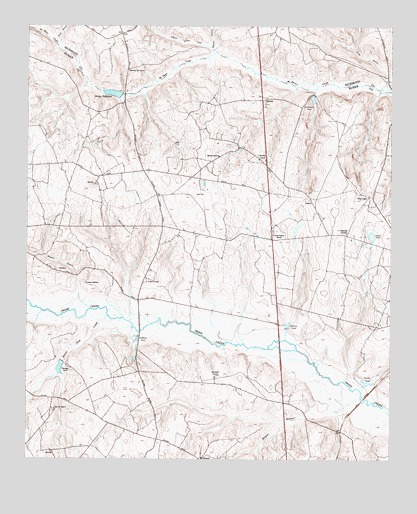
Storys Millpond, GA USGS Topographic Map
Click on map above to begin viewing in our Map Viewer.

This topographic map contains these locations and features:
Feature Name Type Latitude Longitude GNIS ID View Map
Allen BranchStreamN33.2321°W82.0035°347930View Map
Beaver Dam CreekStreamN33.1660°W82.0968°354507View Map
Bines Slave CemeteryCemeteryN33.1793°W82.1134°347940View Map
Burke County Emergency Management Agency Engine Company 7BuildingN33.2009°W82.0797°2604282View Map
Cokes ChapelChurchN33.2013°W82.0073°312808View Map
Crossroads Christian SchoolSchoolN33.2082°W82.0832°347964View Map
Crossroads ChurchChurchN33.2082°W82.0829°347965View Map
Friendship ChurchChurchN33.2118°W82.0451°355941View Map
Goldberg PondReservoirN33.1599°W82.0867°314670View Map
Gordon PondReservoirN33.1897°W82.0063°314719View Map
Green Branch ChurchChurchN33.1901°W82.0401°314823View Map
Green CemeteryCemeteryN33.2057°W82.0048°347991View Map
Gresham CemeteryCemeteryN33.1765°W82.1048°314887View Map
Gresham School (historical)SchoolN33.2118°W82.0457°347993View Map
Grove MountPopulated PlaceN33.2015°W82.0804°347994View Map
Hammond Academy (historical)SchoolN33.1904°W82.0148°356153View Map
Hopeful BranchStreamN33.1685°W82.1029°315632View Map
Jennys BranchStreamN33.2318°W82.0007°316078View Map
New Hope BranchStreamN33.2446°W82.1148°310352View Map
Palmers PondReservoirN33.1517°W82.1132°320166View Map
Rachael Tucker CemeteryCemeteryN33.2207°W82.1209°348039View Map
Rebecca Walker CreekStreamN33.2426°W82.0601°321353View Map
Red Hill ChurchChurchN33.1396°W82.1151°321388View Map
Red Hill School (historical)SchoolN33.1393°W82.1151°348041View Map
Richmond Hill ChurchChurchN33.2376°W82.0898°321587View Map
Rock Hill BranchStreamN33.2324°W82.0257°348045View Map
Saint Antioch ChurchChurchN33.1771°W82.0837°322049View Map
Satchel PondReservoirN33.1474°W82.0079°322570View Map
Shaw LakeReservoirN33.2168°W82.0092°341568View Map
Shaw Lake DamDamN33.2201°W82.0082°341567View Map
Spreadoak ChurchChurchN33.1488°W82.0598°323353View Map
Stockton PondReservoirN33.1639°W82.0352°323637View Map
Storys Mill (historical)LocaleN33.2313°W82.0918°358025View Map
Storys MillpondReservoirN33.2307°W82.0954°339245View Map
Storys Millpond DamDamN33.2301°W82.0926°339244View Map
WAGW-FM (Waynesboro)TowerN33.1882°W82.0357°352822View Map
Walker Scott CemeteryCemeteryN33.1421°W82.0237°348076View Map
Walkers BridgeBridgeN33.1621°W82.0860°348077View Map
Walnut BranchStreamN33.1429°W82.0098°324802View Map
Waynesboro Mennonite SchoolSchoolN33.1329°W82.0360°348083View Map
Wheeler BranchStreamN33.2435°W82.0610°325117View Map
Winters School (historical)SchoolN33.2126°W82.0590°325466View Map
Woodwards PondReservoirN33.2291°W82.0268°325554View Map
Yawn Field (historical)AirportN33.1993°W82.0629°348090View Map

Note: Coordinates in the location and feature list above are referenced to NAD83 datum.


Copyright (C) 2008-2025 Ryan Niemi / Sunset Dynamics ... All Rights Reserved