TopoQuest Logo
Do you find TopoQuest useful?
Help keep TopoQuest running and adding new maps/features by donating!
Bitcoin:  19c7KJd3qBynnjoSw5npx9KScwjBe4ifkT
Litecoin:  LXs6TkuXGGXo1vDsWCkWVdjQX94eUKd6ui
Home View Maps Find Maps Find Places Resources & Links


McCullough, Alabama Topographic Map

USGS Map Title: McCullough, AL
USGS Map MRC: 31087B5
DRG (GeoTIFF) Download: o31087b5.tif


Neighboring USGS Topographic Map Quads:


  Chrysler, AL  
31087C6
 

  Uriah West, AL  
31087C5
 

  Uriah East, AL  
31087C4
 

  Blacksher, AL  
31087B6
 

  McCullough, AL  
31087B5
 

  Huxford, AL  
31087B4
 

  Perdido, AL  
31087A6
 

  Freemanville, AL  
31087A5
 

  Atmore, AL  
31087A4


Map MRC Location:

N32°
W88°
N32°
W87°
H8 H7 H6 H5 H4 H3 H2 H1
G8 G7 G6 G5 G4 G3 G2 G1
F8 F7 F6 F5 F4 F3 F2 F1
E8 E7 E6 E5 E4 E3 E2 E1
D8 D7 D6 D5 D4 D3 D2 D1
C8 C7 C6 C5 C4 C3 C2 C1
B8 B7 B6 B5 B4 B3 B2 B1
A8 A7 A6 A5 A4 A3 A2 A1
N31°
W88°
N31°
W87°

McCullough, AL USGS 1:24K Topographic Map Preview:
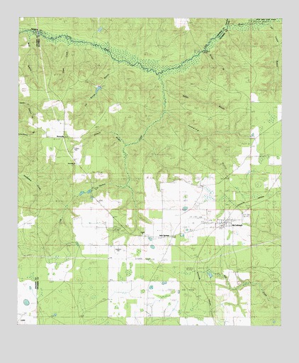
McCullough, AL USGS Topographic Map
Click on map above to begin viewing in our Map Viewer.

This topographic map contains these locations and features:
Feature Name Type Latitude Longitude GNIS ID View Map
BoonevillePopulated PlaceN31.2010°W87.6030°156096View Map
Booneville Baptist ChurchChurchN31.1907°W87.5975°163150View Map
Booneville Church CemeteryCemeteryN31.1918°W87.5978°133954View Map
Bridge BranchStreamN31.2393°W87.5350°114893View Map
Butterfork CreekStreamN31.2463°W87.5269°115325View Map
Clare CreekStreamN31.2410°W87.5986°116168View Map
Corinth ChurchChurchN31.1621°W87.5653°120749View Map
Driskell CemeteryCemeteryN31.1652°W87.5466°117480View Map
George E White DamDamN31.2218°W87.5867°129713View Map
Jack SpringsPopulated PlaceN31.1613°W87.5525°164492View Map
Jack Springs CemeteryCemeteryN31.1649°W87.5472°133813View Map
Jim Boone BranchStreamN31.2330°W87.5792°120887View Map
Jim Lomax BranchStreamN31.2496°W87.5064°120892View Map
Jumping GullyValleyN31.2121°W87.5536°121073View Map
Lake George WhiteReservoirN31.2200°W87.5876°129712View Map
Lindsey CemeteryCemeteryN31.1968°W87.5983°121663View Map
Long Hollow CreekStreamN31.2277°W87.5578°122012View Map
LottiePopulated PlaceN31.1291°W87.6222°122041View Map
McCulloughPopulated PlaceN31.1668°W87.5264°122509View Map
McCullough Post OfficePost OfficeN31.1666°W87.5303°168586View Map
McCullough Volunteer Fire DepartmentBuildingN31.1666°W87.5363°2331084View Map
Mill Post Office (historical)Post OfficeN31.2210°W87.5042°138520View Map
Mothershed CemeteryCemeteryN31.2222°W87.5353°133833View Map
Oxhead BranchStreamN31.2143°W87.6186°124363View Map
Pieburn BranchStreamN31.1982°W87.5717°124702View Map
Prestwood BridgeBridgeN31.2368°W87.5375°125254View Map
Rabbit BranchStreamN31.2218°W87.5555°125391View Map
Steadham CemeteryCemeteryN31.1568°W87.5769°127337View Map
Steadman Chapel ChurchChurchN31.1571°W87.5800°163143View Map
Travelers Rest ChurchChurchN31.1513°W87.5567°128053View Map
Wolf BranchStreamN31.2446°W87.6183°129149View Map

Note: Coordinates in the location and feature list above are referenced to NAD83 datum.


Copyright (C) 2008-2025 Ryan Niemi / Sunset Dynamics ... All Rights Reserved