TopoQuest Logo
Do you find TopoQuest useful?
Help keep TopoQuest running and adding new maps/features by donating!
Bitcoin:  19c7KJd3qBynnjoSw5npx9KScwjBe4ifkT
Litecoin:  LXs6TkuXGGXo1vDsWCkWVdjQX94eUKd6ui
Home View Maps Find Maps Find Places Resources & Links


Uriah West, Alabama Topographic Map

USGS Map Title: Uriah West, AL
USGS Map MRC: 31087C5
DRG (GeoTIFF) Download: o31087c5.tif


Neighboring USGS Topographic Map Quads:


  Gainestown, AL  
31087D6
 

  Flynns Lake, AL  
31087D5
 

  Frisco City, AL  
31087D4
 

  Chrysler, AL  
31087C6
 

  Uriah West, AL  
31087C5
 

  Uriah East, AL  
31087C4
 

  Blacksher, AL  
31087B6
 

  McCullough, AL  
31087B5
 

  Huxford, AL  
31087B4


Map MRC Location:

N32°
W88°
N32°
W87°
H8 H7 H6 H5 H4 H3 H2 H1
G8 G7 G6 G5 G4 G3 G2 G1
F8 F7 F6 F5 F4 F3 F2 F1
E8 E7 E6 E5 E4 E3 E2 E1
D8 D7 D6 D5 D4 D3 D2 D1
C8 C7 C6 C5 C4 C3 C2 C1
B8 B7 B6 B5 B4 B3 B2 B1
A8 A7 A6 A5 A4 A3 A2 A1
N31°
W88°
N31°
W87°

Uriah West, AL USGS 1:24K Topographic Map Preview:
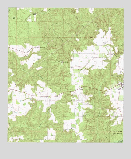
Uriah West, AL USGS Topographic Map
Click on map above to begin viewing in our Map Viewer.

This topographic map contains these locations and features:
Feature Name Type Latitude Longitude GNIS ID View Map
Blacksher Lookout TowerTowerN31.3249°W87.5689°164290View Map
Blacksher SchoolSchoolN31.3010°W87.5014°136491View Map
HomewoodPopulated PlaceN31.3696°W87.5994°156490View Map
Hurricane BranchStreamN31.3121°W87.5169°120577View Map
JeddoPopulated PlaceN31.3324°W87.5142°156526View Map
Jenny Bell HillSummitN31.3599°W87.5317°120854View Map
Morning Star Baptist ChurchChurchN31.3657°W87.6194°164489View Map
Morning Star CemeteryCemeteryN31.3657°W87.6197°1730578View Map
Palmers CrossroadsPopulated PlaceN31.2999°W87.5486°124390View Map
Poplar Springs Baptist ChurchChurchN31.3316°W87.5100°154133View Map
Poplar Springs CemeteryCemeteryN31.3324°W87.5108°1805507View Map
Saint Paul ChurchChurchN31.3288°W87.5183°136625View Map
Sand CreekStreamN31.3710°W87.5839°126304View Map
Semirah Springs CemeteryCemeteryN31.2629°W87.5555°1805633View Map
Semirah Springs Freewill Baptist ChurchChurchN31.2629°W87.5561°155239View Map
UriahPopulated PlaceN31.3052°W87.5022°153822View Map
Uriah CemeteryCemeteryN31.3085°W87.5058°154609View Map
Uriah DivisionCivilN31.3281°W87.6049°165902View Map
Uriah First Baptist ChurchChurchN31.3021°W87.5027°2580392View Map
Uriah Oil FieldOilfieldN31.3238°W87.5139°151209View Map
Uriah Post OfficePost OfficeN31.3061°W87.5040°167046View Map
Uriah United Methodist ChurchChurchN31.3059°W87.5027°2580393View Map
Uriah Volunteer Fire DepartmentBuildingN31.3057°W87.5036°2331010View Map
Wallers Creek Oil FieldOilfieldN31.3216°W87.5742°151211View Map

Note: Coordinates in the location and feature list above are referenced to NAD83 datum.


Copyright (C) 2008-2025 Ryan Niemi / Sunset Dynamics ... All Rights Reserved