TopoQuest Logo
Do you find TopoQuest useful?
Help keep TopoQuest running and adding new maps/features by donating!
Bitcoin:  19c7KJd3qBynnjoSw5npx9KScwjBe4ifkT
Litecoin:  LXs6TkuXGGXo1vDsWCkWVdjQX94eUKd6ui
Home View Maps Find Maps Find Places Resources & Links


Chrysler, Alabama Topographic Map

USGS Map Title: Chrysler, AL
USGS Map MRC: 31087C6
DRG (GeoTIFF) Download: o31087c6.tif


Neighboring USGS Topographic Map Quads:


  Alma, AL  
31087D7
 

  Gainestown, AL  
31087D6
 

  Flynns Lake, AL  
31087D5
 

  Carlton, AL  
31087C7
 

  Chrysler, AL  
31087C6
 

  Uriah West, AL  
31087C5
 

  Tensaw, AL  
31087B7
 

  Blacksher, AL  
31087B6
 

  McCullough, AL  
31087B5


Map MRC Location:

N32°
W88°
N32°
W87°
H8 H7 H6 H5 H4 H3 H2 H1
G8 G7 G6 G5 G4 G3 G2 G1
F8 F7 F6 F5 F4 F3 F2 F1
E8 E7 E6 E5 E4 E3 E2 E1
D8 D7 D6 D5 D4 D3 D2 D1
C8 C7 C6 C5 C4 C3 C2 C1
B8 B7 B6 B5 B4 B3 B2 B1
A8 A7 A6 A5 A4 A3 A2 A1
N31°
W88°
N31°
W87°

Chrysler, AL USGS 1:24K Topographic Map Preview:
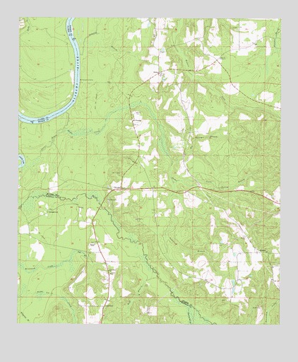
Chrysler, AL USGS Topographic Map
Click on map above to begin viewing in our Map Viewer.

This topographic map contains these locations and features:
Feature Name Type Latitude Longitude GNIS ID View Map
Beat 1 Volunteer Fire DepartmentBuildingN31.3048°W87.6944°2331049View Map
Big Nancey BranchStreamN31.3166°W87.6767°114302View Map
ChryslerPopulated PlaceN31.3052°W87.7011°151732View Map
Cole BranchStreamN31.2763°W87.7253°116402View Map
Duff BranchStreamN31.2716°W87.6855°117635View Map
EliskaPopulated PlaceN31.3527°W87.6830°156304View Map
Eliska ChurchChurchN31.3588°W87.6542°117920View Map
Ferrell CemeteryCemeteryN31.3177°W87.6980°154605View Map
Gentry Store (historical)LocaleN31.3088°W87.6539°136523View Map
GeorgetownPopulated PlaceN31.2966°W87.7355°118907View Map
Grove Hill ChurchChurchN31.3713°W87.6478°154606View Map
Joiner BranchStreamN31.3091°W87.6764°120971View Map
Kellum LandingLocaleN31.3571°W87.7208°136548View Map
Little Nancey BranchStreamN31.3088°W87.6722°121827View Map
Little RiverPopulated PlaceN31.2571°W87.7086°121857View Map
Little River Baptist ChurchChurchN31.3007°W87.7072°152108View Map
Little River ChurchChurchN31.2718°W87.7064°155137View Map
Little River Post OfficePost OfficeN31.2569°W87.7090°2578972View Map
Mamies ChapelChurchN31.2827°W87.7133°122241View Map
MineolaPopulated PlaceN31.2796°W87.6339°156717View Map
Mineola Baptist ChurchChurchN31.2860°W87.6417°152342View Map
Mineola CemeteryCemeteryN31.2863°W87.6419°136571View Map
Mineola ChurchChurchN31.2866°W87.6408°154608View Map
Mount PleasantPopulated PlaceN31.3335°W87.6958°156751View Map
Mount Pleasant ChurchChurchN31.3524°W87.6830°136582View Map
Mount Pleasant ChurchChurchN31.3532°W87.6828°136583View Map
Mount Pleasant LandingLocaleN31.3493°W87.7211°156752View Map
Potts BarBarN31.3363°W87.7305°136611View Map
Potts BayouGutN31.3235°W87.7342°125209View Map
Reedy CreekStreamN31.3674°W87.7497°153125View Map
Shomo CemeteryCemeteryN31.3363°W87.6942°126797View Map
Shomo CreekStreamN31.3366°W87.7275°126798View Map
Strider Store (historical)LocaleN31.3452°W87.6728°136638View Map
Tanyard BranchStreamN31.3599°W87.7208°127672View Map
Triumph ChurchChurchN31.2607°W87.7080°134733View Map
Tucker School (historical)SchoolN31.2821°W87.6375°136642View Map
Weatherford CemeteryCemeteryN31.3282°W87.6608°154607View Map
Weatherford Mill (historical)LocaleN31.3391°W87.6483°136649View Map
Whitney Mill BranchStreamN31.2577°W87.6680°128927View Map
Williams CemeteryCemeteryN31.3007°W87.6883°154604View Map

Note: Coordinates in the location and feature list above are referenced to NAD83 datum.


Copyright (C) 2008-2025 Ryan Niemi / Sunset Dynamics ... All Rights Reserved