TopoQuest Logo
Do you find TopoQuest useful?
Help keep TopoQuest running and adding new maps/features by donating!
Bitcoin:  19c7KJd3qBynnjoSw5npx9KScwjBe4ifkT
Litecoin:  LXs6TkuXGGXo1vDsWCkWVdjQX94eUKd6ui
Home View Maps Find Maps Find Places Resources & Links


McDade, Texas Topographic Map

USGS Map Title: McDade, TX
USGS Map MRC: 30097C2
DRG (GeoTIFF) Download: o30097c2.tif


Neighboring USGS Topographic Map Quads:


  Structure, TX  
30097D3
 

  Beaukiss, TX  
30097D2
 

  Lexington, TX  
30097D1
 

  Elgin East, TX  
30097C3
 

  McDade, TX  
30097C2
 

  Fedor, TX  
30097C1
 

  Lake Bastrop, TX  
30097B3
 

  Smithville NW, TX  
30097B2
 

  Paige, TX  
30097B1


Map MRC Location:

N31°
W98°
N31°
W97°
H8 H7 H6 H5 H4 H3 H2 H1
G8 G7 G6 G5 G4 G3 G2 G1
F8 F7 F6 F5 F4 F3 F2 F1
E8 E7 E6 E5 E4 E3 E2 E1
D8 D7 D6 D5 D4 D3 D2 D1
C8 C7 C6 C5 C4 C3 C2 C1
B8 B7 B6 B5 B4 B3 B2 B1
A8 A7 A6 A5 A4 A3 A2 A1
N30°
W98°
N30°
W97°

McDade, TX USGS 1:24K Topographic Map Preview:
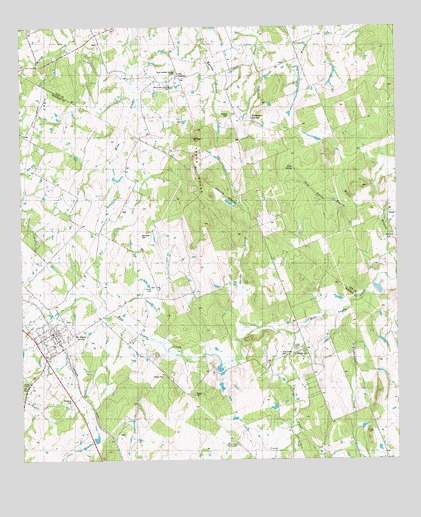
McDade, TX USGS Topographic Map
Click on map above to begin viewing in our Map Viewer.

This topographic map contains these locations and features:
Feature Name Type Latitude Longitude GNIS ID View Map
Dube CemeteryCemeteryN30.3149°W97.2108°1334710View Map
Gum SpringSpringN30.3344°W97.1589°1337128View Map
Gum Spring BranchStreamN30.3230°W97.1375°1337129View Map
High Hill CemeteryCemeteryN30.2799°W97.1633°1337704View Map
High Hill ChurchChurchN30.2805°W97.1555°1337705View Map
Knobbs SpringsPopulated PlaceN30.3605°W97.1978°2034637View Map
Knobbs SpringsSpringN30.3419°W97.1919°1998518View Map
Marshy BranchStreamN30.2883°W97.1714°1340997View Map
McDadePopulated PlaceN30.2838°W97.2378°1341178View Map
McDade Census Designated PlaceCensusN30.2819°W97.2449°2586957View Map
McDade Post OfficePost OfficeN30.2861°W97.2410°2732159View Map
McDade Volunteer Fire DepartmentBuildingN30.2865°W97.2383°2552363View Map
Mid Springs CreekStreamN30.2527°W97.1661°1341466View Map
New Knobbs Springs CemeteryCemeteryN30.3616°W97.1983°1342492View Map
Old Knobbs Springs CemeteryCemeteryN30.3574°W97.1994°1343173View Map
Paint CreekStreamN30.2863°W97.1592°1343429View Map
Roanoke Public LibraryBuildingN30.2738°W97.2272°2014805View Map
Rocky CreekStreamN30.2597°W97.1611°1345445View Map
Sanders CemeteryCemeteryN30.3491°W97.1800°1346558View Map
The KnobbsLocaleN30.3605°W97.1942°1348451View Map
Yegua KnobbsSummitN30.3335°W97.1925°1350663View Map

Note: Coordinates in the location and feature list above are referenced to NAD83 datum.


Copyright (C) 2008-2025 Ryan Niemi / Sunset Dynamics ... All Rights Reserved