TopoQuest Logo
Do you find TopoQuest useful?
Help keep TopoQuest running and adding new maps/features by donating!
Bitcoin:  19c7KJd3qBynnjoSw5npx9KScwjBe4ifkT
Litecoin:  LXs6TkuXGGXo1vDsWCkWVdjQX94eUKd6ui
Home View Maps Find Maps Find Places Resources & Links


McDavid, Florida Topographic Map

USGS Map Title: McDavid, FL
USGS Map MRC: 30087G3
DRG (GeoTIFF) Download: o30087g3.tif


Neighboring USGS Topographic Map Quads:


  Bratt, FL  
30087H4
 

  Century, FL  
30087H3
 

  Jay, FL  
30087H2
 

  Bay Springs, FL  
30087G4
 

  McDavid, FL  
30087G3
 

  Chumuckla, FL  
30087G2
 

  Barrineau Park, FL  
30087F4
 

  Molino, FL  
30087F3
 

  Wallace, FL  
30087F2


Map MRC Location:

N31°
W88°
N31°
W87°
H8 H7 H6 H5 H4 H3 H2 H1
G8 G7 G6 G5 G4 G3 G2 G1
F8 F7 F6 F5 F4 F3 F2 F1
E8 E7 E6 E5 E4 E3 E2 E1
D8 D7 D6 D5 D4 D3 D2 D1
C8 C7 C6 C5 C4 C3 C2 C1
B8 B7 B6 B5 B4 B3 B2 B1
A8 A7 A6 A5 A4 A3 A2 A1
N30°
W88°
N30°
W87°

McDavid, FL USGS 1:24K Topographic Map Preview:
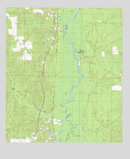
McDavid, FL USGS Topographic Map
Click on map above to begin viewing in our Map Viewer.

This topographic map contains these locations and features:
Feature Name Type Latitude Longitude GNIS ID View Map
Andrew Mitchell GrantCivilN30.8538°W87.3216°304068View Map
BarthPopulated PlaceN30.7616°W87.3303°278131View Map
Bell CreekStreamN30.7921°W87.3022°278420View Map
Black BranchStreamN30.7919°W87.3628°278877View Map
Blue Water CreekStreamN30.7957°W87.3669°279078View Map
BogiaPopulated PlaceN30.8424°W87.3244°295144View Map
Brown LakeLakeN30.7947°W87.3077°279477View Map
Canoe CreekStreamN30.8596°W87.3103°115589View Map
Celestino Gonzalez GrantCivilN30.8224°W87.3100°304073View Map
Chumuckla SpringsPopulated PlaceN30.8338°W87.2961°280447View Map
Chumuckla Springs Post Office (historical)Post OfficeN30.8338°W87.2961°2026958View Map
Collier/Pine Barren AirparkAirportN30.8267°W87.3572°309314View Map
Coon Hill CemeteryCemeteryN30.8588°W87.2797°280756View Map
Cotton CreekStreamN30.8477°W87.3189°280880View Map
Cotton LakeLakeN30.7848°W87.3134°280885View Map
Delaney CreekStreamN30.7535°W87.2897°281475View Map
Diamond CreekStreamN30.8371°W87.2944°281547View Map
Escambia River State Wildlife Management AreaParkN30.7980°W87.2986°1986197View Map
Fletcher CreekStreamN30.7835°W87.3116°282572View Map
Gully BranchStreamN30.7877°W87.3580°283514View Map
Henry Michalet GrantCivilN30.7938°W87.3222°304074View Map
Henry O'Neal GrantCivilN30.8413°W87.3216°304071View Map
Horseshoe LakeLakeN30.8737°W87.3035°284316View Map
John Ruiz GrantCivilN30.8385°W87.3114°304072View Map
Juniper CemeteryCemeteryN30.8021°W87.2694°284987View Map
Juniper ChurchChurchN30.8021°W87.2694°301627View Map
McDavidPopulated PlaceN30.8663°W87.3197°286601View Map
McDavid ChurchChurchN30.8566°W87.3236°286602View Map
McDavid CreekStreamN30.8305°W87.2872°286603View Map
McDavid Post OfficePost OfficeN30.8660°W87.3226°2783430View Map
McDavid SchoolSchoolN30.8566°W87.3236°304066View Map
McDavid Volunteer Fire DepartmentBuildingN30.8698°W87.3219°2644137View Map
Mineral SpringsPopulated PlaceN30.8327°W87.2958°301626View Map
Moore CreekStreamN30.8030°W87.2833°287103View Map
Morgan BranchStreamN30.7755°W87.3408°287123View Map
Morgan CemeteryCemeteryN30.7541°W87.3461°287124View Map
Pine BarrenPopulated PlaceN30.7774°W87.3344°288821View Map
Rays ChapelChurchN30.8430°W87.3333°289520View Map
Thomas Thrifts GrantCivilN30.8746°W87.3125°304067View Map
V Ordosgoity GrantCivilN30.8557°W87.3197°304069View Map
Wiggins BridgeBridgeN30.7994°W87.3678°293269View Map
WKGT-FM (Century)TowerN30.8694°W87.3383°310164View Map

Note: Coordinates in the location and feature list above are referenced to NAD83 datum.


Copyright (C) 2008-2024 Ryan Niemi / Sunset Dynamics ... All Rights Reserved