TopoQuest Logo
Do you find TopoQuest useful?
Help keep TopoQuest running and adding new maps/features by donating!
Bitcoin:  19c7KJd3qBynnjoSw5npx9KScwjBe4ifkT
Litecoin:  LXs6TkuXGGXo1vDsWCkWVdjQX94eUKd6ui
Home View Maps Find Maps Find Places Resources & Links


McLeansville, North Carolina Topographic Map

USGS Map Title: McLeansville, NC
USGS Map MRC: 36079A6
DRG (GeoTIFF) Download: o36079a6.tif


Neighboring USGS Topographic Map Quads:


  Lake Brandt, NC  
36079B7
 

  Browns Summit, NC  
36079B6
 

  Ossipee, NC  
36079B5
 

  Greensboro, NC  
36079A7
 

  McLeansville, NC  
36079A6
 

  Gibsonville, NC  
36079A5
 

  Pleasant Garden, NC  
35079H7
 

  Climax, NC  
35079H6
 

  Kimesville, NC  
35079H5


Map MRC Location:

N37°
W80°
N37°
W79°
H8 H7 H6 H5 H4 H3 H2 H1
G8 G7 G6 G5 G4 G3 G2 G1
F8 F7 F6 F5 F4 F3 F2 F1
E8 E7 E6 E5 E4 E3 E2 E1
D8 D7 D6 D5 D4 D3 D2 D1
C8 C7 C6 C5 C4 C3 C2 C1
B8 B7 B6 B5 B4 B3 B2 B1
A8 A7 A6 A5 A4 A3 A2 A1
N36°
W80°
N36°
W79°

McLeansville, NC USGS 1:24K Topographic Map Preview:
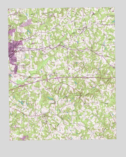
McLeansville, NC USGS Topographic Map
Click on map above to begin viewing in our Map Viewer.

This topographic map contains these locations and features:
Feature Name Type Latitude Longitude GNIS ID View Map
Alamance ChurchChurchN36.0229°W79.7075°980072View Map
Alamance SchoolSchoolN36.0176°W79.7070°980074View Map
Aydelette LakeReservoirN36.0395°W79.7011°999946View Map
Aydelette Lake DamDamN36.0385°W79.6981°1017332View Map
Beaver CreekStreamN36.0432°W79.6636°980793View Map
BessemerPopulated PlaceN36.0837°W79.7428°1019102View Map
Bessemer Elementary SchoolSchoolN36.0896°W79.7381°1006598View Map
Bessemer Shopping CenterLocaleN36.0957°W79.7456°1007939View Map
Bethel ChurchChurchN36.0896°W79.6395°981162View Map
Buchanan ChurchChurchN36.0810°W79.7081°982089View Map
Carolina HospitalHospitalN36.0854°W79.7411°1023882View Map
Causey LakeLakeN36.0346°W79.7284°982781View Map
Causey Lake DamDamN36.0346°W79.7284°999942View Map
Center ChurchChurchN36.0710°W79.7334°982930View Map
Englewood ForestPopulated PlaceN36.0412°W79.7492°1005007View Map
Erwin Open Elementary SchoolSchoolN36.0926°W79.7450°1006597View Map
Forbis LakeReservoirN36.0037°W79.7285°999893View Map
Forbis Lake DamDamN36.0051°W79.7281°999894View Map
Franklin Boulevard ChapelChurchN36.0712°W79.7409°985368View Map
Fryar LakeReservoirN36.0918°W79.7208°1000058View Map
Fryar Lake DamDamN36.0918°W79.7198°1000059View Map
Greensboro Fire Department Station 56BuildingN36.0645°W79.7417°2638571View Map
Greesons CrossroadsPopulated PlaceN36.0349°W79.6386°1020558View Map
Guilford County Fire Station 37BuildingN36.0756°W79.6405°2639668View Map
Guilford County Fire Station 47BuildingN36.1064°W79.6593°2638529View Map
Guilford County Fire Station 54BuildingN36.0205°W79.7068°2638650View Map
Hackett LakeReservoirN36.0356°W79.7346°986278View Map
Higgins LakeReservoirN36.0491°W79.6898°999984View Map
Higgins Lake DamDamN36.0485°W79.6897°999983View Map
Jorden BranchStreamN36.1154°W79.7270°987786View Map
Joseph Allred DamDamN36.0168°W79.7498°999911View Map
Laughlin Memorial ChurchChurchN36.0957°W79.7320°988167View Map
Lynnwood LakeReservoirN36.0005°W79.7339°989152View Map
Lynwood Lake DamDamN36.0040°W79.7311°999887View Map
McConnell Road ChurchChurchN36.0543°W79.6878°989543View Map
McLeansvillePopulated PlaceN36.1074°W79.6586°989614View Map
McLeansville Census Designated PlaceCensusN36.1045°W79.6554°2403270View Map
McLeansville ChurchChurchN36.0946°W79.6311°989615View Map
McLeansville Middle SchoolSchoolN36.1057°W79.6614°1006603View Map
McLeansville Post OfficePost OfficeN36.1094°W79.6593°2774032View Map
Midway CemeteryCemeteryN36.1118°W79.7150°989819View Map
Midway ChurchChurchN36.1060°W79.6959°989831View Map
Mount Pleasant ChurchChurchN36.0868°W79.6806°990550View Map
Mount ZionPopulated PlaceN36.0971°W79.7259°1021564View Map
Mount ZionSchoolN36.0954°W79.7295°1006599View Map
Muddy CreekStreamN36.1099°W79.7414°990761View Map
North Buffalo ChapelChurchN36.1201°W79.7411°991199View Map
Piedmont Memorial CemeteryCemeteryN36.0610°W79.7497°992166View Map
Saint James ChurchChurchN36.0949°W79.7481°993918View Map
Sedalia Elementary SchoolSchoolN36.0682°W79.6270°1006604View Map
Shady Grove CemeteryCemeteryN36.0637°W79.6975°994534View Map
Stewarts MillPopulated PlaceN36.0421°W79.6656°995506View Map
Township of GilmerCivilN36.1058°W79.7455°1026736View Map
Township of JeffersonCivilN36.0744°W79.6726°1026740View Map
Troxlers MillPopulated PlaceN36.0404°W79.6828°1022990View Map
Twin Oaks ChurchChurchN36.0819°W79.6481°2374869View Map
Woodard Memorial ChurchChurchN36.0660°W79.7417°997574View Map
Youth Focus Psychiatric HospitalHospitalN36.0973°W79.7268°2701551View Map

Note: Coordinates in the location and feature list above are referenced to NAD83 datum.


Copyright (C) 2008-2024 Ryan Niemi / Sunset Dynamics ... All Rights Reserved