TopoQuest Logo
Do you find TopoQuest useful?
Help keep TopoQuest running and adding new maps/features by donating!
Bitcoin:  19c7KJd3qBynnjoSw5npx9KScwjBe4ifkT
Litecoin:  LXs6TkuXGGXo1vDsWCkWVdjQX94eUKd6ui
Home View Maps Find Maps Find Places Resources & Links


McMullen Basin, Idaho Topographic Map

USGS Map Title: McMullen Basin, ID
USGS Map MRC: 42114C4
DRG (GeoTIFF) Download: o42114c4.tif


Neighboring USGS Topographic Map Quads:


  Berger, ID  
42114D5
 

  Hub Butte, ID  
42114D4
 

  Stricker Butte, ID  
42114D3
 

  Hollister, ID  
42114C5
 

  McMullen Basin, ID  
42114C4
 

  Grand View Peak, ID  
42114C3
 

  Rogerson, ID  
42114B5
 

  Hopper Gulch, ID  
42114B4
 

  Pike Mountain, ID  
42114B3


Map MRC Location:

N43°
W115°
N43°
W114°
H8 H7 H6 H5 H4 H3 H2 H1
G8 G7 G6 G5 G4 G3 G2 G1
F8 F7 F6 F5 F4 F3 F2 F1
E8 E7 E6 E5 E4 E3 E2 E1
D8 D7 D6 D5 D4 D3 D2 D1
C8 C7 C6 C5 C4 C3 C2 C1
B8 B7 B6 B5 B4 B3 B2 B1
A8 A7 A6 A5 A4 A3 A2 A1
N42°
W115°
N42°
W114°

McMullen Basin, ID USGS 1:24K Topographic Map Preview:
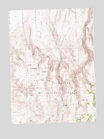
McMullen Basin, ID USGS Topographic Map
Click on map above to begin viewing in our Map Viewer.

This topographic map contains these locations and features:
Feature Name Type Latitude Longitude GNIS ID View Map
Arkansas SpringSpringN42.2832°W114.4562°376709View Map
Basin SpringSpringN42.2577°W114.3892°377015View Map
Burnt CreekStreamN42.3357°W114.4484°378545View Map
Cottonwood BasinBasinN42.2607°W114.4245°379820View Map
Cottonwood Ridge SpringSpringN42.2816°W114.4131°379866View Map
Curtis ReservoirReservoirN42.3173°W114.4065°380184View Map
Donahue CreekStreamN42.3071°W114.3953°380713View Map
Dry Cottonwood ReservoirReservoirN42.3056°W114.4491°380804View Map
Dry Fork ReservoirReservoirN42.3249°W114.4481°380854View Map
Goat SpringsSpringN42.2891°W114.4625°382343View Map
Grassy SpringSpringN42.3041°W114.4606°382580View Map
Hoops SpringSpringN42.3269°W114.4642°383317View Map
Horse BasinBasinN42.2949°W114.4381°383349View Map
Horse Basin SpringSpringN42.2966°W114.4411°383353View Map
Lunch SpringSpringN42.2763°W114.4364°386292View Map
McMullen BasinBasinN42.2566°W114.4020°386654View Map
McMullen Cow CampLocaleN42.2530°W114.3998°386655View Map
Moonshine SpringSpringN42.3230°W114.4456°387145View Map
North Cottonwood RidgeRidgeN42.2716°W114.4106°401654View Map
North Willow Springs CreekStreamN42.3535°W114.3867°387860View Map
Rice Creek SpringSpringN42.2527°W114.4734°389337View Map
Rimrock SpringSpringN42.2971°W114.4517°389390View Map
Squaw Joe SpringSpringN42.3135°W114.4731°391306View Map
Upper Burnt Creek ReservoirReservoirN42.3099°W114.4607°392620View Map
Williams DamDamN42.2721°W114.4225°398652View Map
Williams ReservoirReservoirN42.2685°W114.4228°398362View Map
Williams SpringSpringN42.2807°W114.4712°395813View Map
Williams SpringSpringN42.2810°W114.4712°399609View Map

Note: Coordinates in the location and feature list above are referenced to NAD83 datum.


Copyright (C) 2008-2024 Ryan Niemi / Sunset Dynamics ... All Rights Reserved