TopoQuest Logo
Do you find TopoQuest useful?
Help keep TopoQuest running and adding new maps/features by donating!
Bitcoin:  19c7KJd3qBynnjoSw5npx9KScwjBe4ifkT
Litecoin:  LXs6TkuXGGXo1vDsWCkWVdjQX94eUKd6ui
Home View Maps Find Maps Find Places Resources & Links


Pike Mountain, Idaho Topographic Map

USGS Map Title: Pike Mountain, ID
USGS Map MRC: 42114B3
DRG (GeoTIFF) Download: o42114b3.tif


Neighboring USGS Topographic Map Quads:


  McMullen Basin, ID  
42114C4
 

  Grand View Peak, ID  
42114C3
 

  Rams Horn Ridge, ID  
42114C2
 

  Hopper Gulch, ID  
42114B4
 

  Pike Mountain, ID  
42114B3
 

  Trapper Peak, ID  
42114B2
 

  Big Creek Ranch, ID  
42114A4
 

  Timber Butte, ID  
42114A3
 

  Mahogany Butte, ID  
42114A2


Map MRC Location:

N43°
W115°
N43°
W114°
H8 H7 H6 H5 H4 H3 H2 H1
G8 G7 G6 G5 G4 G3 G2 G1
F8 F7 F6 F5 F4 F3 F2 F1
E8 E7 E6 E5 E4 E3 E2 E1
D8 D7 D6 D5 D4 D3 D2 D1
C8 C7 C6 C5 C4 C3 C2 C1
B8 B7 B6 B5 B4 B3 B2 B1
A8 A7 A6 A5 A4 A3 A2 A1
N42°
W115°
N42°
W114°

Pike Mountain, ID USGS 1:24K Topographic Map Preview:
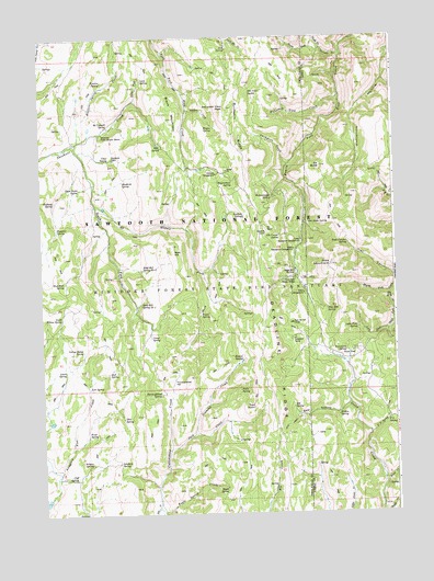
Pike Mountain, ID USGS Topographic Map
Click on map above to begin viewing in our Map Viewer.

This topographic map contains these locations and features:
Feature Name Type Latitude Longitude GNIS ID View Map
Ashbury SpringSpringN42.1385°W114.3585°376742View Map
Bald HillSummitN42.1935°W114.3281°396063View Map
Bald Hill Spring Number 1SpringN42.1803°W114.3402°376874View Map
Bald Hill Spring Number 2SpringN42.1891°W114.3393°376875View Map
Bear HollowValleyN42.1535°W114.2686°377162View Map
Black MountainSummitN42.2288°W114.3281°377764View Map
Blind CreekStreamN42.1335°W114.2553°377859View Map
Blue Mud SpringSpringN42.1857°W114.3673°377937View Map
Buckskin RidgeRidgeN42.2255°W114.3056°378437View Map
Bud SpringSpringN42.1623°W114.3518°378438View Map
Buzzard SpringSpringN42.2001°W114.3694°378623View Map
Camp SpringSpringN42.1713°W114.3367°378814View Map
Chad SpringSpringN42.2182°W114.3507°379147View Map
Cliff SpringSpringN42.1344°W114.3642°379435View Map
Deadline CorralLocaleN42.1985°W114.2956°380323View Map
Deer SpringSpringN42.2219°W114.3331°380479View Map
Diamond CreekStreamN42.1460°W114.3220°380566View Map
Eagle SpringSpringN42.1317°W114.3109°381000View Map
Eagle Spring CreekStreamN42.1263°W114.3353°381001View Map
Electric SpringSpringN42.2386°W114.3530°381311View Map
Electric Spring CreekStreamN42.2230°W114.3617°381312View Map
Elk BasinBasinN42.1996°W114.2936°381328View Map
Elk ButteSummitN42.2160°W114.2761°381331View Map
Elk Butte SpringSpringN42.2016°W114.2803°381334View Map
Elk Corral SpringSpringN42.1980°W114.2900°381336View Map
Elk SpringSpringN42.1529°W114.2868°381394View Map
F S SpringSpringN42.1487°W114.2541°381525View Map
F S Spring CreekStreamN42.1457°W114.2597°381526View Map
Fawn SpringSpringN42.1771°W114.3190°381632View Map
Frahm SpringSpringN42.1506°W114.2711°382007View Map
Halfway SpringSpringN42.2071°W114.3703°382823View Map
Hinton SpringSpringN42.1658°W114.3048°383221View Map
Jack CreekStreamN42.1421°W114.3303°383797View Map
Joes SpringSpringN42.2469°W114.3085°383941View Map
Kirkman CampgroundLocaleN42.2141°W114.3131°384258View Map
Kum Ba Yah CampLocaleN42.1749°W114.2870°384315View Map
Lamb SpringSpringN42.1626°W114.3672°384398View Map
Lava SpringSpringN42.2389°W114.3387°384484View Map
Little Fork SpringSpringN42.1735°W114.2640°384835View Map
Lost SpringSpringN42.1582°W114.3589°386183View Map
Lower Penstemon CampgroundLocaleN42.1966°W114.2834°386237View Map
Magic Mountain Ski AreaLocaleN42.1882°W114.2856°386355View Map
McConnell SpringSpringN42.2269°W114.3509°386582View Map
Middle Fork Shoshone CreekStreamN42.2066°W114.3556°386845View Map
Middle Fork Third Fork Rock CreekStreamN42.1827°W114.2522°386852View Map
Mountain View CreekStreamN42.2335°W114.2700°387303View Map
Mountain View PeakSummitN42.2316°W114.3089°387305View Map
Mountain View SpringSpringN42.2355°W114.3011°387306View Map
Narrows CreekStreamN42.2455°W114.2684°387476View Map
North Fork Narrows CreekStreamN42.2469°W114.2750°387743View Map
North Fork Shoshone CreekStreamN42.2335°W114.3420°387779View Map
Orin SpringSpringN42.1501°W114.3471°387996View Map
Pedro SpringSpringN42.1574°W114.3056°388320View Map
Pettit CampgroundLocaleN42.1827°W114.2822°388385View Map
Pike MountainSummitN42.1899°W114.2728°388448View Map
Pike Mountain SpringSpringN42.1788°W114.2743°388449View Map
Pond SpringSpringN42.1459°W114.3596°388718View Map
Porcupine SpringSpringN42.1682°W114.2678°388769View Map
Porcupine Spring Picnic AreaLocaleN42.1663°W114.2639°388773View Map
Rickenbacker SpringSpringN42.2079°W114.2932°389352View Map
Rock Creek Guard StationLocaleN42.1863°W114.2856°389507View Map
Ross FallsFallsN42.2149°W114.2897°400961View Map
Sanitary SpringSpringN42.1386°W114.3485°389914View Map
Shoshone CabinLocaleN42.2182°W114.3498°390375View Map
Shoshone Forest Service StationLocaleN42.2249°W114.3528°390379View Map
Shoshone SpringSpringN42.2125°W114.3462°390383View Map
South Fork Narrows CreekStreamN42.2469°W114.2750°390980View Map
South Fork Shoshone CreekStreamN42.2219°W114.3642°375154View Map
South Willow SpringSpringN42.1768°W114.3679°391083View Map
Stove Gulch SpringSpringN42.2106°W114.3613°391513View Map
Summit SpringSpringN42.2027°W114.3035°391639View Map
Tawakani CampLocaleN42.1710°W114.2859°391856View Map
Thoroughbred FlatFlatN42.1596°W114.3286°392063View Map
Thoroughbred SpringSpringN42.1566°W114.3333°392065View Map
Tool PointCliffN42.1532°W114.3009°392240View Map
Toolbox CreekStreamN42.2313°W114.3231°392241View Map
Trail CanyonValleyN42.1869°W114.2509°392261View Map
Trail Canyon SpringSpringN42.1957°W114.2667°392268View Map
Upper Penstemon CampgroundLocaleN42.1944°W114.2859°392643View Map
Wagon SpringSpringN42.2264°W114.3137°392765View Map
Wagonwheel SpringSpringN42.2125°W114.3074°392771View Map
Yellow Jacket SpringSpringN42.1683°W114.3609°393746View Map

Note: Coordinates in the location and feature list above are referenced to NAD83 datum.


Copyright (C) 2008-2025 Ryan Niemi / Sunset Dynamics ... All Rights Reserved