TopoQuest Logo
Do you find TopoQuest useful?
Help keep TopoQuest running and adding new maps/features by donating!
Bitcoin:  19c7KJd3qBynnjoSw5npx9KScwjBe4ifkT
Litecoin:  LXs6TkuXGGXo1vDsWCkWVdjQX94eUKd6ui
Home View Maps Find Maps Find Places Resources & Links


McNatt, Missouri Topographic Map

USGS Map Title: McNatt, MO
USGS Map MRC: 36094F3
DRG (GeoTIFF) Download: o36094f3.tif


Neighboring USGS Topographic Map Quads:


  Neosho West, MO  
36094G4
 

  Neosho East, MO  
36094G3
 

  Stella, MO  
36094G2
 

  Anderson, MO  
36094F4
 

  McNatt, MO  
36094F3
 

  Bethpage, MO  
36094F2
 

  Noel, MO  
36094E4
 

  Jane, MO  
36094E3
 

  Powell, MO  
36094E2


Map MRC Location:

N37°
W95°
N37°
W94°
H8 H7 H6 H5 H4 H3 H2 H1
G8 G7 G6 G5 G4 G3 G2 G1
F8 F7 F6 F5 F4 F3 F2 F1
E8 E7 E6 E5 E4 E3 E2 E1
D8 D7 D6 D5 D4 D3 D2 D1
C8 C7 C6 C5 C4 C3 C2 C1
B8 B7 B6 B5 B4 B3 B2 B1
A8 A7 A6 A5 A4 A3 A2 A1
N36°
W95°
N36°
W94°

McNatt, MO USGS 1:24K Topographic Map Preview:
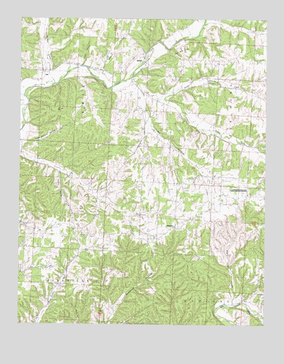
McNatt, MO USGS Topographic Map
Click on map above to begin viewing in our Map Viewer.

This topographic map contains these locations and features:
Feature Name Type Latitude Longitude GNIS ID View Map
Barlow School (historical)SchoolN36.7173°W94.2997°713654View Map
Big Cedar HollowValleyN36.6340°W94.2663°714149View Map
Bullskin CreekStreamN36.7217°W94.3616°715031View Map
Bunker School (historical)SchoolN36.6626°W94.3466°715053View Map
Christian Church (historical)ChurchN36.7209°W94.3149°715815View Map
Coal Mine HillSummitN36.7340°W94.2933°716036View Map
Dry HollowValleyN36.7173°W94.3110°717119View Map
Elkhorn CreekStreamN36.7248°W94.3219°717465View Map
Elkhorn Tower State Public Hunting GroundsParkN36.6801°W94.2635°742065View Map
EriePopulated PlaceN36.7278°W94.3633°717622View Map
Happy HollowValleyN36.7290°W94.3347°719069View Map
Hungry HollowValleyN36.6881°W94.3549°719993View Map
Indian Springs School (historical)SchoolN36.7420°W94.3191°720145View Map
Little Cedar HollowValleyN36.6348°W94.2597°721187View Map
McCullough FordPopulated PlaceN36.6292°W94.2530°741049View Map
McDonald CountyCivilN36.6287°W94.3484°758518View Map
McNattPopulated PlaceN36.7356°W94.3127°722166View Map
MoralLocaleN36.6748°W94.2641°745862View Map
Mount Carmel ChurchChurchN36.6751°W94.2647°722731View Map
North Elkhorn CreekStreamN36.7190°W94.3058°723443View Map
Peach Orchard HollowValleyN36.6984°W94.3733°724143View Map
PlainviewPopulated PlaceN36.6651°W94.2960°724454View Map
Puckett School (historical)SchoolN36.6823°W94.3044°724986View Map
Salt Lick GapGapN36.7124°W94.3567°725976View Map
Steep HollowValleyN36.7309°W94.3435°727057View Map
Township of Erie McNattCivilN36.7086°W94.3342°766948View Map
Township of Pineville NorthCivilN36.6286°W94.3619°766953View Map
WyliePopulated PlaceN36.6601°W94.3330°740465View Map

Note: Coordinates in the location and feature list above are referenced to NAD83 datum.


Copyright (C) 2008-2024 Ryan Niemi / Sunset Dynamics ... All Rights Reserved