TopoQuest Logo
Do you find TopoQuest useful?
Help keep TopoQuest running and adding new maps/features by donating!
Bitcoin:  19c7KJd3qBynnjoSw5npx9KScwjBe4ifkT
Litecoin:  LXs6TkuXGGXo1vDsWCkWVdjQX94eUKd6ui
Home View Maps Find Maps Find Places Resources & Links


McSherrystown, Pennsylvania Topographic Map

USGS Map Title: McSherrystown, PA
USGS Map MRC: 39077G1
DRG (GeoTIFF) Download: o39077g1.tif


Neighboring USGS Topographic Map Quads:


  Biglerville, PA  
39077H2
 

  Hampton, PA  
39077H1
 

  Abbottstown, PA  
39076H8
 

  Gettysburg, PA  
39077G2
 

  McSherrystown, PA  
39077G1
 

  Hanover, PA  
39076G8
 

  Taneytown, MD  
39077F2
 

  Littlestown, PA  
39077F1
 

  Manchester, MD  
39076F8


Map MRC Location:

N40°
W78°
N40°
W77°
H8 H7 H6 H5 H4 H3 H2 H1
G8 G7 G6 G5 G4 G3 G2 G1
F8 F7 F6 F5 F4 F3 F2 F1
E8 E7 E6 E5 E4 E3 E2 E1
D8 D7 D6 D5 D4 D3 D2 D1
C8 C7 C6 C5 C4 C3 C2 C1
B8 B7 B6 B5 B4 B3 B2 B1
A8 A7 A6 A5 A4 A3 A2 A1
N39°
W78°
N39°
W77°

McSherrystown, PA USGS 1:24K Topographic Map Preview:
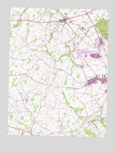
McSherrystown, PA USGS Topographic Map
Click on map above to begin viewing in our Map Viewer.

This topographic map contains these locations and features:
Feature Name Type Latitude Longitude GNIS ID View Map
Ace Emergency Medical ServicesBuildingN39.8623°W77.0675°2719491View Map
Annunciation of Blessed Virgin Mary CemeteryCemeteryN39.8096°W77.0176°2774871View Map
Ashgrove SchoolSchoolN39.7557°W77.1091°1168451View Map
Berlin JunctionPopulated PlaceN39.8559°W77.0355°1203069View Map
Bethlehem Limestone QuarryMineN39.8336°W77.0269°2633847View Map
BittingerPopulated PlaceN39.8379°W77.0144°1203104View Map
Borough of McSherrystownCivilN39.8035°W77.0199°1214760View Map
Borough of New OxfordCivilN39.8630°W77.0555°1214761View Map
Brush RunPopulated PlaceN39.8620°W77.0978°1203176View Map
Brush RunStreamN39.8715°W77.1066°1170448View Map
Brush Run SchoolSchoolN39.8384°W77.1008°1170461View Map
BrushtownPopulated PlaceN39.7979°W77.0461°1170470View Map
Cedar RidgePopulated PlaceN39.8462°W77.1111°1203239View Map
CentennialPopulated PlaceN39.8154°W77.0589°1171417View Map
Center SchoolSchoolN39.7554°W77.0394°1214728View Map
Christ United Church of Christ CemeteryCemeteryN39.7573°W77.0558°2774875View Map
Church StationLocaleN39.7557°W77.0555°1205936View Map
Clearview SchoolSchoolN39.8676°W77.0583°1171979View Map
Conewago ChapelChurchN39.8193°W77.0378°1172313View Map
Conewago Chapel Basilica CemeteryCemeteryN39.8190°W77.0362°2774872View Map
Conewago Township Police DepartmentBuildingN39.8200°W77.0232°2754589View Map
Cross KeysPopulated PlaceN39.8709°W77.0275°1172741View Map
Eastern Adams Regional Police DepartmentBuildingN39.8661°W77.0533°2754559View Map
EdgegrovePopulated PlaceN39.8184°W77.0330°1174001View Map
Felty SchoolSchoolN39.7887°W77.0772°1174678View Map
Green SpringsPopulated PlaceN39.8490°W77.0033°1176117View Map
Hanover AirportAirportN39.7929°W77.0240°1193741View Map
Hanover QuarryMineN39.8336°W77.0292°2566584View Map
Hanover ReservoirReservoirN39.7742°W77.0342°1176480View Map
Hostetters Meeting House CemeteryCemeteryN39.7826°W77.0580°2774892View Map
Immaculate Conception Catholic Church CemeteryCemeteryN39.8657°W77.0454°2774895View Map
Indian RunStreamN39.7665°W77.0080°1177779View Map
IrishtownPopulated PlaceN39.8382°W77.0491°1177835View Map
Irishtown Fire Company Station 14BuildingN39.8356°W77.0486°2653117View Map
John's Burnt Mill BridgeBridgeN39.8325°W77.0797°2723089View Map
Kaiser LakeLakeN39.8330°W77.0759°1212672View Map
Kilpatrick SchoolSchoolN39.8568°W77.1108°1178456View Map
Kohler SchoolSchoolN39.8490°W77.0794°1178639View Map
LefevreLocaleN39.7534°W77.0580°1212671View Map
Locust Grove SchoolSchoolN39.7965°W77.0403°1179779View Map
McSherryPopulated PlaceN39.7859°W77.0136°1211099View Map
McSherrystownPopulated PlaceN39.8073°W77.0114°1180806View Map
McSherrystown Police DepartmentBuildingN39.8037°W77.0190°2754598View Map
McSherrystown Post OfficePost OfficeN39.8036°W77.0195°2756674View Map
MidwayPopulated PlaceN39.8084°W77.0028°1181080View Map
Midway Ambulance ServiceBuildingN39.8057°W77.0031°2100055View Map
Midway Census Designated PlaceCensusN39.8039°W77.0052°2389481View Map
Moritz SchoolSchoolN39.8645°W77.1208°1181559View Map
Mount MiseryPopulated PlaceN39.8398°W77.0436°1181746View Map
Mount PleasantPopulated PlaceN39.7795°W77.0064°1181795View Map
New OxfordPopulated PlaceN39.8637°W77.0558°1182353View Map
New Oxford Area LibraryBuildingN39.8667°W77.0550°2100244View Map
New Oxford CemeteryCemeteryN39.8608°W77.0672°2774920View Map
New Oxford Community Fire CompanyBuildingN39.8642°W77.0580°2100013View Map
Northern Low Dutch CemeteryCemeteryN39.8715°W77.1188°2774900View Map
Pigeon HillSummitN39.8587°W77.0078°1183713View Map
Pleasant Hill SchoolSchoolN39.7629°W77.0908°1184043View Map
Plum CreekStreamN39.8193°W77.0422°1184107View Map
Red Hill SchoolSchoolN39.8454°W77.0328°1184760View Map
Saint Joseph AcademySchoolN39.8001°W77.0253°1186186View Map
Saint Joseph Academy CemeteryCemeteryN39.7984°W77.0240°2774934View Map
Saint Luke Lutheran Church CemeteryCemeteryN39.8007°W77.1200°2774936View Map
Saint Vincent's Catholic CemeteryCemeteryN39.7984°W77.0077°2774911View Map
Sells StationLocaleN39.7648°W77.0378°1187246View Map
Sheppard DamDamN39.7634°W77.0147°1194353View Map
Sheraton Breeding FarmLocaleN39.7597°W77.0886°2650598View Map
Southeastern Adams Volunteer Emergency Services Station 2BuildingN39.7977°W77.0401°2100019View Map
Southeastern Adams Volunteer Emergency Services Station 29BuildingN39.7965°W77.0351°2100011View Map
Square CornerPopulated PlaceN39.8095°W77.1061°1204715View Map
Township of ConewagoCivilN39.7977°W77.0239°1215778View Map
Township of Mount PleasantCivilN39.8268°W77.1115°1215791View Map
Township of OxfordCivilN39.8490°W77.0438°1215792View Map
Township of UnionCivilN39.7571°W77.0470°1215796View Map
Valley Grove School (historical)SchoolN39.7679°W77.0586°1211100View Map
Valley SchoolSchoolN39.8076°W77.0978°1190310View Map
WhitehallPopulated PlaceN39.7909°W77.1094°1191320View Map
Whitehall SchoolSchoolN39.7848°W77.1053°1191324View Map
WHVR-AM (Hanover)TowerN39.8198°W77.0066°1200333View Map
Xanthus FarmLocaleN39.8356°W77.1042°2650597View Map

Note: Coordinates in the location and feature list above are referenced to NAD83 datum.


Copyright (C) 2008-2025 Ryan Niemi / Sunset Dynamics ... All Rights Reserved